Cádiz (Spain)

Roman aqueduct of Cádiz (Spain)

Cádiz - GADEZ / COL. AUGUSTA GADITANA
For the photo's, see below
For the complete website

The aqueduct

Cádiz had an aqueduct of more than 83 km long, the longest in the Iberian peninsula and one of the largest in the roman world. The aqueduct may have been one of the projects set up by L. Cornelius Balbus Minor. It was needed not only for the growing population of the city, but also for the locally important industry of the fish-sauce garum, a kind of all purpose condiment of the ancient world similar in taste to our soy sauce.

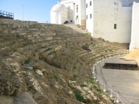
The remains of the Roman theater in Cádiz were discovered in 1980. The theatre is only partially excavated and was likely built during the 1st century BCE. It was the second largest ever built in the Roman empire, abandoned in the 4th century CE and in the 13th century a fortress was built on its ruins by order of King Alfonso X of Castile.
From: Wikipedia

The source and two siphons

The source of the aqueduct are the springs of Tempul, 122 m a.s.l. near the medieval Tempul castle south of the Guadalgacin Reservoir. These springs still feed the water supply of Jerez and other towns. Possibly, the recently discovered basins and springs of Sierra Aznar, east of Arcos de la Frontera may also have fed into the aqueduct but no connection has as yet been found. From the source area, the aqueduct was built as a buried masonry conduit with a 3,5 km long and 100 m deep siphon section across the Salado de Paterna valley on a venter bridge. The Salado siphon started at 132 m altitude at Cerro de los Arquillos Altos (note the toponym - range of the high arcs!) and ran over an up to 25m high bridge to Loma de la Torre at 129 m near the estate of Isletes de San Luis.
The aqueduct - 0,56 m wide and 1,48 m high - approached Gades from the east, from Llanos de Guerra near Puerto Real and travelled the flat lying area between Portus Gaditanus and the city in a second siphon (Cádiz siphon) in three rows of parallel tubes. This must have been one of the longest siphons in the roman world, of nearly 20 km. The tubes probably crossed a bridge across the straits to the island of Cádiz, a predecessor of the medieval Puente Zuazo, and ran along the western shore towards the city. The siphon emptied into four large basins of 56 x 17 m and 3 - 4 m deep at the SE side of the city near the amphitheatre at an altitude of 18-19m above sea level. The Ermita de San Roque was built on the remains of these cisterns, behind the present Puertas de Tierra. The aqueduct could deliver 6.000 - 8.000 m3 of water per day.

The Cádiz siphon

The Cádiz siphon was built of perforated limestone blocks. Each block measures about 0,86 x 0,80 m and is 0,28 - 0,50 m thick. The blocks have a flat bottom and roughly worked semicircular top, and are perforated with a smooth drilled hole, showing an extension of the perforated part on one side, and a hollow part where it fits in opposite block. The holes are drilled normal to the layering in the limestone. The internal diameter of the perforation is 0,22 - 0,25 cm and the rims of the "male" blocks are 0,09 m thick. The distance between the base of the blocks and the bottom of the perforation is 0,22 m. Perforated blocks of this type were also used in other parts of the empire, for example in Asia Minor for the aqueducts of Patara and Aspendos, in Zadar, Croatia, in Bonn (Germany) and Jerusalem (Palestine). From the remains it is not clear how they were made waterproof, since the rock used is a very porous calcareous sandstone.

We do not know presently if the entire section between Los Arquillos in the northern suburb of Chiclana de la Frontera and Cádiz was pressurised in a siphon of 20 km long. It may be, of course, that only some stretches were pressurised, separated by normal open channel sections. The perforated blocks are obviously less desirable as building material and therefore remain, while the more desirable other works would have been dismantled and used for building stone; the flat marshy area around Cádiz is poor in building stone and it would have been tempting to use the aqueduct. Nevertheless, the entire section is nearly at sea level, and using an open conduit would have meant building an aqueduct bridge of nearly 20 m high on instable alluvium, which would have meant heavy, wide foundation blocks. Since no such foundations have been found, the entire section may indeed have been a siphon which would have been cheaper , less subject to settlement and easier to repair. If the entire section was pressurised it must have been the longest one in the Roman Empire, requiring up to 150.000 siphon blocks as described above, 50.000 tons of limestone in all.
The map shows the approximate course of the aqueduct.

Written sources

In the absence of archaeological data, some information can be obtained from Arab sources. During the Arab occupation of Spain, the aqueduct was no longer in use but it was still visible, and the siphon mentioned above made quite an impression on contemporaries. For example, Yaqut, who lived in the 12th-13th Century wrote about Tempul: "In the subsoil there is a fresh water spring which the ancients canalized and led to the island of Cádiz in male-female stones; they crossed bridges and the mountains and there, where they found chasms they constructed bridges and siphons until arriving at the sea where they put it into channels of six miles long until its arrival at Cádiz..." and "... as far as the water which we have talked about that had been brought to Cádiz, it was led by means of a construction in the middle of the sea from the firm, solid Earth, covered with lead and protected with rocks and an impermeable layer, so that the water of the sea could not filter in...." (Gamal abd-al-Karim, pages 75-76 and 237 in Chic García, 2004). Notice that Yaqut only mentions 6 miles, although the map gives the double distance. Obviously, this is a subject that would be interesting to investigate further.

The Cádiz aqueduct was the recently the focus of study of the research group Aqua Ducta and was the subject of a PhD thesis in 2012 by J. Perez.

The city of Cádiz

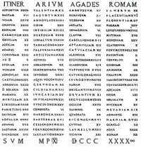
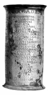
Cádiz is one of the oldest cities of Europe, founded by the Phoenicians in the 9th Century BC, but possibly even as early as 1100 BC with the name Gadir. It was conquered by the Romans in 209 BC and despite its remote location, developed into a rich, important city with the name Gades. Gades must have been a fascinating place in antiquity. It was then the westernmost city of the Empire on the shore of the Atlantic Ocean beyond the pillars of Hercules at what was then the end of the known world. Gades was a bustling metropolis of commerce, with temples, an amphitheatre, and a theatre all in the narrow space of two elongate islands forming great natural harbours. According to Strabo, space was no problem "...since the inhabitants are nearly always at sea...". L. Cornelius Balbus Minor, friend of Julius Caesar, and native of Gades expanded the city and enriched it with many monuments. The city grew rapidly under Augustus and the early emperors and harboured the famous temple of Hercules-Mekart at the tip of the southern island. The city was so famous for its remoteness, that souvenirs were made in the shape of silver milestones (known as the Vicarello silver cups) inscribed with a long list of towns between Rome and Gades.
In the late empire the city fell into decline by lack of trade opportunities, which worsened when it was conquered by the Visigoths. Occupied by a people without a strong seafaring tradition, and with the empire gone, the city reduced to a village in a field of ruins by the fourth century
A silver cup - from the early first century CE - in the form of a milestone, has been found (with three other such cups) in Vicarello (Italy). On the cups the itinerary, with distances specified from Cadiz to Rome (Itinerarim a Gades Romam). The illustrated side of one of the cups provides, among others places like (in the accusative, which indicates the direction) Nemausus (Nimes), Arelata (Arles) Cabellio (Cavaillon), Segustero (Sisteron) Taurim (Torino) and Ticinum (Pavia).

Visible remains

Substantial remains of the aqueduct must still have remained visible until relatively late. Felipe II of Spain sent the Carmelite Father Ambrosio Mariano to investigate the possibilities to restore the aqueduct and divert its water to Jerez. At the end of the 18th century the military governor of Cádiz, O'Reilly, tried to have the aqueduct restored for the water supply of his city. Nothing was achieved, however, and the ruins deteriorated further so that nowadays very few remains are visible, although substantial remains may still be present in the subsoil. In 1869 the original springs were captured for the water supply of Jerez, and a modern aqueduct was built to that city.

Scant remains of the aqueduct are visible at the following sites:

El Mimbral - 300m of the buried conduit is preserved here close to the springs of Tempul, south of the road, with several circular service shafts. The conduit is 170 cm high and 50-55cm wide. The vault is in rubble filled masonry constructed on a centring. The impression of eight planks of the centring is still visible in the concrete.

Cortijo de los Arquillos - some remains of rubble masonry blocks that are probably the remains of the venter bridge of the Salado siphon. One pillar is still standing in the bed of the Salado de Paterna creek (also locally known as the arroyo Arquilón)

Llanos de Guerra (Puerto Real) - inspection shaft

Los Arquillos (Chiclana) - single tower of the aqueduct, several metres high, of rubble masonry. This may be one of the pressure towers of the siphon section that lies just downstream.

Tres Caminos - Along highway A4 / E5 between Puerto Real and San Fernando at km 674 on the south side of the road is a small parking bay with tile-map where a section of three rows of perforated limestone blocks of the siphon are exposed. The three parallel pipes were discovered, interestingly enough, in 1989 during excavations for an extension of the present water supply of Cádiz. Seventy metres of the conduit were found, of which 25 metres had to be removed. Part of these have been reconstructed in their original setting and orientation, and reinstalled along the road a few metres from where they have been found.

Playa de Cortadura (Playa Chato) - Along this southern beach of Cádiz one can find remains of both a roman road (a retaining wall at the southern end of the beach), and about 450 loose limestone blocks of the aqueduct siphon in the sand. Some blocks of basalt may have belonged to an unknown structure associated with the aqueduct. The blocks are visible at low tide. The remains lie opposite the flyover and the Calle de Puerto Santa Maria, 700m south of the Castillo de Cortadura, the first building of Cádiz on the causeway. In the summer of 2006, some of the siphon blocks were unfortunately damaged by beach cleaning activities of the Cádiz authorities.

Plaza Hasdrubal - Another section of reconstructed siphon is visible in this town square south of the main road and north of Playa Victoria, the Plaza Hasdrubal. The section is on a pedestal along the north side of the square. The stones were taken from the Cortadura beach and placed here in 1982. They are much weathered compared to the blocks at Tres Caminos after centuries in the surf of the ocean.

C.W. Passchier

Cádiz - Gades / COL. AUGUSTA GADITANA

Item Info
Length 83,35 km
Cross-section 0,56 m x 1,48 m
Volume 6.000 - 8.000 m3/day
Fall 0,13 %
Period Augustan
Features
  • dropshafts
  • 2 siphons (3,5 & 19,5 km)
  • bridges & tunnels


Recommended literature :
  • J. Perez (2012): El trazado del acueducto romano de Cádiz (PhD-thesis). Of special interest are the chapters 3.4 and 4.1 and 4.2
  • J. Perez (2009): Avance del estudio hidraulico del acueducto romano de Gades. Traianus 2009
  • J. Perez (2010): Nuevas aportaciones al estudio hidraulico des acueducto romano de Tempul, Aquam perducendam curavit
  • J. Perez, E. Moleroand I. Bestue (2011): Nueva metodología para el estudio del trazado del primer tramo del acueducto romano de Tempul Desde la captación hasta la Garganta del Valle. In: Actas del septimo congreso nacional de la construccion.
Recommended websites   :
How to visit                  : GPS coordinates of Cádiz (Plaza Asdrubal): 36 31 03N and 06 17 02W

HOME More literature on more aqueducts Last modified: May, 2015 - (webmaster)


Aqueduct map

Inside the channel

Substructure

Overgrown

Disappointing masonry

Almost in situ

Female side

Male side

Inside the pipe

Plaza Asdrubal

Not in situ

Male and female

Wheathered stones

Limestone blocks