| For the photo's, see below |
| Home / the complete website |
In early times, the town of Acre primarily relied on internal sources of water: wells were used to tap the subterranean water table, while cisterns were constructed in which rainwater from the roofs was collected. Of the two, cisterns were most likely the preferred source of water due to the vulnerability of well water to contamination. However, given the infrequency of precipitation in northern Israel, wells were a more reliable source of water. In addition to internal sources, historical accounts of Acre make reference to two springs: 'Ain al-Bakr and al-Sitt (Bersche 2009, pag 7).
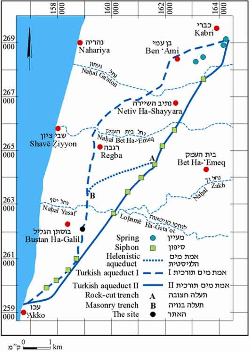 |
| Map of the three aqueducts north of Acre. Note the seven siphon towers (suterazi towers) in the almost disappeared Ottoman aqueduct of Al-Jazzer Pascha (the almost straight line, indicated as II). Of the more recent Suleiman aqueduct (the striped, left line) only four towers are shown. |
Hellenistic aqueduct
During the summer of 1975 a rock-cut unplastered tunnel was discovered, part of an ancient aqueduct carrying water from the springs of Kabri to Acre. Being subterranean, it may have utilized the waters of the 'En Shefa spring, which is the lowest and most abundant of the four springs in the vicinity of Kabri. Several sections of the 'Hellenistic' aqueduct were found including those near Ness Ammim and the kibbutz Lochamei Hagetaot. Found pottery lamps suggest a dating at the end of the 4th or beginning of the 3rd century BC/BCE (Frankel 2002).Al-Jazzer Pascha aqueduct
With the Mamluk invasion in the 13th century AD/CE, the city was demolished and remained virtually inhabited for the next 500 years. It was not until Acre was claimed by Daher el-Omar as the capital of his new fiefdom, that the city's infrastructure began to be rebuilt. By the time of al-Jazzar's rule, the city population had reached the number of 40.000. In response to the fast population growth Al-Jazzar Pascha (1770 - 1804) implemented a major building campaign including the construction of an aqueduct (end 18th c). During Napoleon's siege of Acre in 1799, he cut the water supply, diverting it for use by its own army. The remains of this aqueduct are insufficient to get a clear idea about the water distribution at that time (Bersche 2009 pag 8). This Al-Jazzer aqueduct must have been equipped with six siphon towers (suterazi), see map.Suleiman Pascha aqueduct
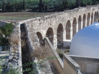
In 1812 Suleiman Pascha, the adopted son of Al-Jazzar Pascha, initiated a complete reconstruction of the original aqueduct. It took a new course, west of the previous one, in order to facilitate the irrigation of the pascha's fields. What is still present today of the water system of Acre, is part of Suleiman's aqueduct, built in 1814 - 1815. This aqueduct was after many repairs, in operation until 1948.Note that, contrary to what some scholars previously assumed, there is no archaeological evidence to support the assumption that one or other of the Ottoman aqueducts, were built on Roman foundations, nor do any of the early travelers, whose descriptions of Acre are in some cases very extensive, mention particular remains of aqueducts (Frankel 2002).
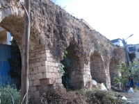
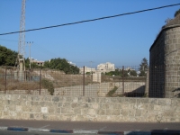
The Suleiman's aqueduct consists of four main parts: the sources, the raised channel, the siphon course with suterazi towers, and the distribution within the town of Acre. The aqueduct took its water from four springs in the Kabri area: 'En Shayyara, 'En Zuf, 'En Giah, and 'En Shefa, and it crossed three streams: Nahal Ga'aton, Nahal Bet-Ha'Emeq, and Nahal Yasaf. The springs are at a level of 70m asl while the town is at sea level. Its total length is 14 km so its fall is 0,5% which is not uncommon for a (Roman) aqueduct.
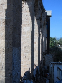
During the main part of its course, the water was transported in an open raised channel of 0,50 x 0,80 m, coated with watertight plaster, often on a substruction or on arches. In Mazra'a some arches were collapsed due to undermining by the river Nahal Bet-Ha'Emeq; the alternative chosen was a local siphon with some concrete and an iron pipe under the local road and the stream.
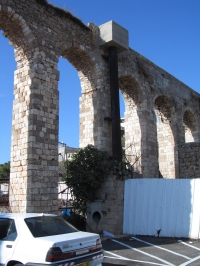
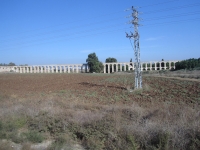
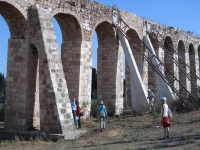
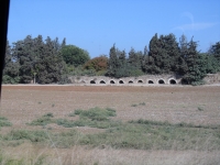
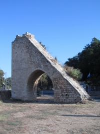
The most visible part can be found along Highway 4 from Acre to Nahariya, just south of the open air theater of kibbutz Lochamei Hagetaot. Apart from some recent repairs (extra supports) of a arcade, one sees also a double level structure with sloping work under the present channel: based on the original design a siphon was constructed to cross the Nahal Yasaf creek; on a ater date this idea was abandoned in favor of a series of tall arches on the original level of the arcade.
For a preview of this section one can use Google Streetview and focus just south of the open air theater.
Seven siphon towers
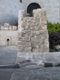
Near the outskirts of Acre the arcade came to an end inside the Manof Youth Village where - after passing the 'header tank' in the first suterazi tower (El Bahja), the transport continued in an covered pipeline. The pressure of the sliding water pushed the water through the pipeline until the next tower, some 500 m further on. The pipeline comprised of stone units with a typical size of 0,60 x 0,35 x 0,35 m and an internal diameter of 0,20 m. The units were tight together by means of interlocking male / female ends plus a special coating at the seams.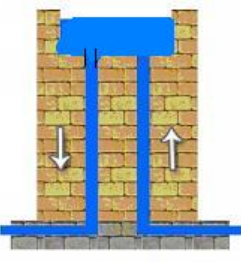 |
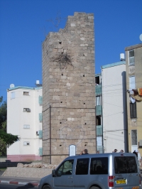
| A model of a siphon / suterazi tower as present in the Suleiman aqueduct of Acre. Often there was a tap at ground level for cattle and/or private consumption. |
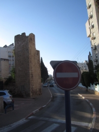
The next suterazi tower is called El A'uoji / El Uja (the bended, the twisted), at the crossroad of the Arieh Dushnitski and the Derech HaMichlala, south of the Western Galilee College. Its name was derived from the bend which directs the aqueduct towards the south-west.
'Su terazi' is Turkish for water tower or water balance. These suterazi towers were built to operate according to Pascal's law of fluid pressure. At the top of each tower was an open tank of several cubic meters. The purposes of these towers were:
· To supply water to the higher parts of the town without pressure loss
· To function as an air relief valve to prevent a pressure surge resulting from sudden cessation of the water flow
· To allow a water outlet for public use and irrigation at several points along the aqueduct without loss of water pressure
· To make possible the efficient identification of blockage locations in specific sections of the pipe.
At the inside of the towers were stone protrusions or hollows to serve as footholds for maintenance personnel.
The following suterazi tower, at the end of the Derech HaArba'a near the corner with the David Remez street (north of the Railway Station), was called El Imam. Its name is derived from the family of the imam of Acre who lived in the adjacent stone building till the 1950's.
In the David Noy street of Acre, one can find the suterazi tower Bab'Aka, clamped in between the flat buildings.
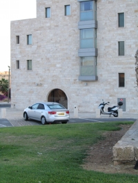
The fifth tower is at the edge of the outer moat of old Acre, some 150 m east of the Weitzman street.
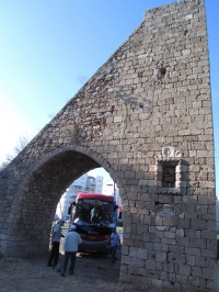
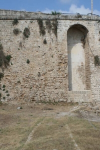
The water continued via a subterranean pipeline to the next 'tower' which is mere an eight meters high arch built into the outer wall, sheltering a basin with a volume of about 4,5 m3. A hole on top op the arch made it possible for the personnel guarding the walls of Acre, to scoop water with a rope and bucket.
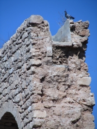
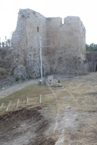
A stone pipe covered by a thick encasement of rubble carried the water to the seventh and last suterazi tower, built into the wall of Daher el-Omar. A significant position of the pipe and surrounding rubble is now exposed; at the time of usage it was probable located 10 - 15 cm below ground level. The water rose via a stone pipe to the top of tower 7 and passed through a basin with a potential volume of 1,7 m3, before descending by one or two vertical pipes into the city. The first one was built as an attachment onto the wall. A second pipe was located inside the basin on the side closest to the town, and presumably led to the underground conduit that fed the first distribution station. The water entered the basin through a stone pipe and left it in a clay pipe from almost the same diameter (Bersche 2009 pag 22 en 27).
Distribution in the city
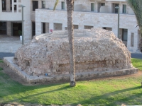
The first distribution basin - right in the middle of the square in front of the Knights Youth Hostel - was set on a platform of 9 m square. The actual basin measured outside 7 m square and almost 2,5 m above the platform.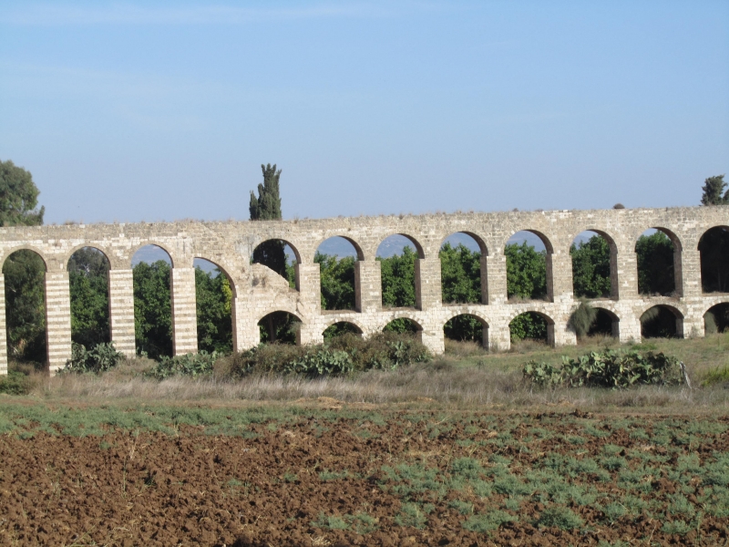 |
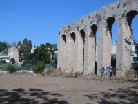
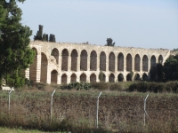
| The most visible part of the Suleiman aqueduct of Acre just south of kibbutz Lochamei Hagetaot (Israel) |
The basin proper was encased within a larger stone structure which has gradually eroded and lost several stones to theft. The inside of the basin was of octagonal shape and terraced into three layers. The bottom section - the largest - was accessible by three small steps that presumably ended right above the water level. In the middle to late 20th century the inside of the basin was plastered leaving no indication where the pipes entered or exited. The function of the basin was primarily to distribute the water while also some settling took place.
Major water consumers were the al-Jazzar mosque and its adjacent hammam (ritual washing and pleasure bathing), pasha's fields in this area (irrigation), and - by means of branch pipes and sebils - the public (consumption).
As indicated in the street pavement, the open aqueduct line which fed the second distribution basin, was not supplied by the first distribution basin north of the Youth Hostel but direct from the last suterazi tower. The channel - about 0,30 x 0,30 m - was supported by a substruction of about 0,90 m wide and (in some places) over 2 meter high. The most striking part of the Ottoman aqueduct inside Acre is through (!) the east side of the Youth Hostel and over its court yard.
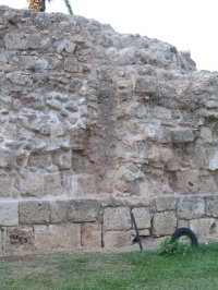
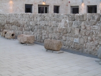
At the end of the aqueduct the water came into a second distribution basin, north of the White Market. Here also some settling took place. This structure is now in an advanced state of ruin. Traces of clay pipes cling to the sides. Probably this basin was an Ottoman maksem, a domed or vaulted building containing large water basins with spillways and distribution chambers with nozzles called lülu's, the common Ottoman standard pipe with an internal diameter of 7,4 cm. Some types were also in use as measurement sprouts, to be compared to the Roman calix (Frontinus 36, 105 and 112). From this maksem / distribution basin several sebils (Ottoman fountains) in Acre must have been fed.
Wilke Schram
Partly based on:
· Biblewalks
· Bersche 2009, also on the web
· Akkopedia
· Frankel 2002
Other relevant literature:
· Fountains in Istanbul
· Tsuk 2011 pag 98 - 109 (in Hebrew)
Additional remark
Serious allegations have been put forward that during the siege of Acre in May 1948, Israeli forces have contaminated intentionally the aqueduct water with typhoid fever to weaken the Arabic forces in the town, see Avner Cohen: Israel and Chemical / Biological Weapons, The Non-proliferation review / Fall - Winter 2001, also on the web.
Acre / Akko - PTOLEMAIS
| Item | Info |
|---|---|
| Length | 14 km |
| Cross-section | 0,50 m x 0,80 m |
| Volume | m3/day |
| Gradient | 0,5 % |
| Period | 1815 (Ottoman !) |
| Features |
|
| Recommended literature : | see above |
| Recommended websites : | see above |
| How to visit : | see above |
| HOME | More literature on more aqueducts | Last modified: April, 2013 - (webmaster) |