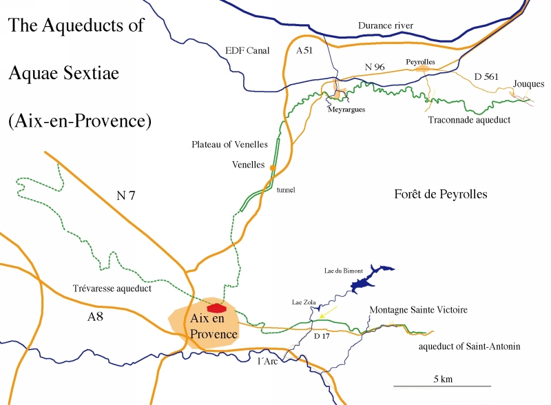
Aix-en-Provence (France)
Roman aqueducts: Aix-en-Provence (France)
Aix-en-Provence - AQUAE SEXTIAE
The Roman town of Aquae Sextiae was served by at least three aqueducts, known as the aqueducts of Traconnade, Saint-Antonin and Vauvenargues. Several other stretches of
aqueducts are known in the surroundings - like the Touloubre - but their source and purpose are unknown, and may have served villas or cisterns in the countryside.
A particular problem in Aix-en-Provence is that no remains of any of the aqueducts have been found in or close to the modern city, so that the final destination of the
main aqueducts and their relative age remains obscure. We here describe two aqueducts of which remains can easily be visited: Traconnade and Saint-Antonin.
Use for reference IGN-map 3244ET.
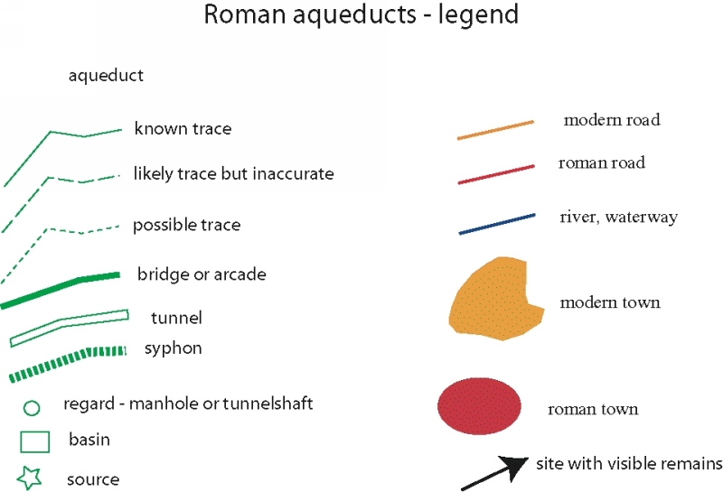
 |
| Legend: click to enlage |
Traconnade
The Traconnade aqueduct had it source at Bouillidous, east of Jouques at Traconnade, south of the Durance river. The precise location of the source is uncertain, but
possible candidates were located on the north side of the Réal valley. The aqueduct crossed the St.-Bachi-river in this valley on a wall or low bride and ran in westerly
direction along the contour lines, mostly in tunnels or rock cuts in the local soft limestone. At Meyrargues it crossed two deep valleys on bridges, after which the aqueduct
turned south in the direction of Aix. In order to reach the city from Meyrargues, the aqueduct had to cross the watershed of the Venelles plateau to the valley of the Arc
where Aix is located, but this is 80 meters higher that the level of the aqueduct. The Roman engineers therefore built a tunnel 7-8 km long below the Venelles plateau.
The tunnel was dug in soft marl, but it is nevertheless an impressive feat of engineering. It was built from shafts up to 80m deep which have been completely faced with masonry.
The actual tunnel has not yet been found and investigated, but was probably faced as well, since it was built in clay which swells in contact with water. South of the tunnel,
the trace of the aqueduct is largely unknown. The total length of the aqueduct is appr. 50 km, resulting in a mean fall of 0,14%, as the source in the Traconnade area
is on 272 m.a.s. and in Aix-en-Provence about 200 m.a.s. The typical cross-section is 1,90 m high and 0,60 m wide.
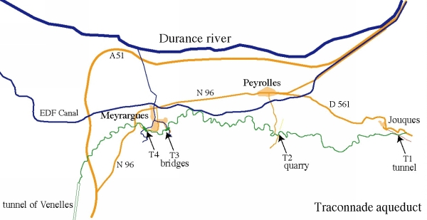 |
| T1 Tunnel entrance S of Jouques |
| T2 Quarry Sainte Anna |
| T3 Val des Arcs, E of Meyrargues |
| T4 Réclavier, W of Meyrargues |
|
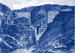
Relation with Roquefavour
In the 19th century, when plans were developed to build an aqueduct from the Durance to Marseille, one option was to follow the trace of the Traconnade aqueduct at a lower level,
and even to use the ancient Roman tunnel to build a modern one at a deeper level. The leading engineer, however, resisted this plan and even cast doubt on the existence
of the tunnel because he was an admirer of the roman aqueduct bridge at Nimes, the Pont du Gard: he saw the new aqueduct as an opportunity to build a larger and more
impressive 'Pont du Gard', and did not want to let his vision be spoiled by a tunnel. The result was the giant Roquefavour bridge.
Visible remains
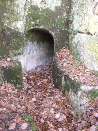
Tunnel
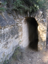
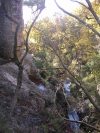
About 1 km southeast of Jonques along a minor road that runs along the south side of the Réal valley, where a rock face lies close to the road, is the entrance of a tunnel,
the first visible structure of the aqueduct. In the tunnel, sections of the rock wall have been chiseled out and replaced by sections of masonry wall (petit appareil) flush with
the rock wall, presumably where the rock was fractured. It is possible to enter the tunnel for a considerable length, but be careful since it is relatively low and narrow.
Park opposite the tunnel at the side of the road. Hint: The place is locally known as Bastine de Thenoux / Couloubleau, and lies about 1 km southeast of Jouques along
the minor road parallel to the D561 along the south side of the Réal valley.
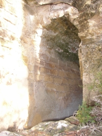
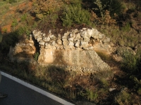
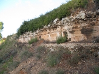
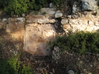
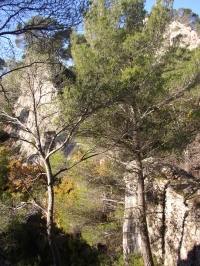
Rock cuts in Santa Anna quarry
The Santa Anna quarry in Miocene limestone lies almost 2 km south of Peyrolles-en-Provence along the Chemin du Loubatas. Follow this dirt road for about 1 km until you see
a red fire hydrant along the left side of the road, where a dirt track branches off to the left. Park on the grass opposite the red fire hydrant and walk up to the quarry along
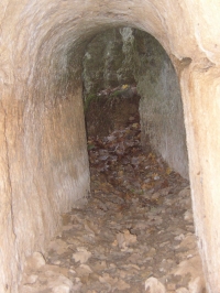
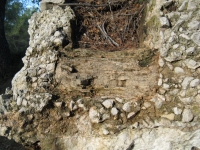
a track lined with wheel ruts of carts that once transported blocks out of the quarry. In the quarry, it is possible to see four cross-sections of the Traconnade aqueduct,
two in the outside walls, and a short section in an "island" of rock that was left standing in the middle of the quarry. All sections can be entered although they may be partly flooded.
The aqueduct was locally built by cutting a T-shaped slot into the limestone from above. A vault was built from elongate roughly worked voussoirs on the shoulders of the "T".
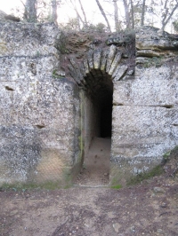
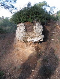
At the east side of the quarry, the tunnel entrance lies at the site of a manhole: besides and above the entrance, one can see the masonry of the manhole superstructure.
Hint: in Peyrolles take the road to the south, direction Sainte-Anne, cross the Canal de l'E.D.F. and follow the dirt road called Chemin de Loubatas.
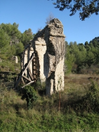
Meyrargues Pas l'Etroit bridge
This 40 m long bridge spanned the Arcs valley with eight arches. Two 9 meter tall arches and five pillars are still standing. The arches are in concrete faced with
'petit appareil' masonry. The springing of the arches consists of a single thin massive slab of limestone. Hint: take the Chemin de l'Endroit SE of the local cemetery
which lies E of the Castle.
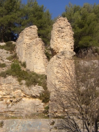
Meyrargues Réclavier bridge
This aqueduct bridge was a large bridge with two tiers. Remains of piers, the 'Pilliers de Réclavier', are visible on both sides of the valley, those on the north side being
best preserved. Hint: coming from Aix-en-Provence take the N96 direction north. One km before Meyrargues take the D62e to the right (Avenue de la République).
After 500 m park your car after you passed a bridge.
Venelles tunnel
No remains of this spectacular, 7-8 km long tunnel - from Fontbelle to the south, globally parallel to the D556 / N96 and E of Venelles - can easily be visited, but several shafts
that were used to built the tunnel with the qanat method, some up to 80m deep, still exist. Several of these have been investigated by local speleologists. The tunnel itself
was cut by the motorway during its construction, but other sections that may still exist underground have not yet been investigated.
Saint-Antonin aqueduct
The Saint-Antoine aqueduct has its source on the south side of the Mont Sainte-Victoire, NE of Saint-Antonin-sur-Bayon and ran for the first 3 km along the north side of the Bayeux river. It followed the present D17 (Route Cézanne) in a straight line E-W to Aix-en-Provence. The sources are presently in use and no Roman structures are preserved. The aqueduct channel is followed for a long stretch by the present RD 17 road and cut several times. The aqueduct crossed the streams draining the Montagne Sainte-Victoire on bridges, one of which was up to 40 m high. The last 4 km of the channel are not preserved.
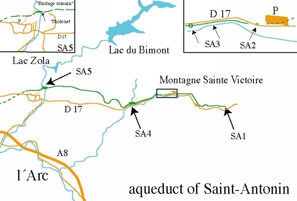 |
| SA1 Source |
| SA2 First visible section |
| SA3 Side wall with manhole |
SA4 One pillar of the bridge
crossing a tributary |
| SA5 'Barrage Romain' |
|
Visible remains
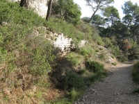
Pont de l'Anchois
Park on the small parking at the N side of the D17 to Saint Antonin-sur-Bayon just before the turnoff to Beaurecueil and walk back along the road. Some 50 meters back lies
a spectacular 5 meters long curve of aqueduct channel is completely preserved along the north side of the road. The specus rests on a concrete foundation and the concrete walls
of the channel were poured between scaling, with a flat top: a masonry vault of roughly worked voussoirs was subsequently constructed on top of the sidewalls.
From this channel section, cross the road and descend to a track that runs parallel to the road at a lower level in the grass along the Bayeau creek. The outer or inner
specus wall is visible just below the road for a 300 m long stretch. Almost at the end of the visible remains, opposite a lonely tree on the north side of the road, the
northern part of a manhole is visible below the road, the masonry of the shaft nearly reaching the road level. Below the manhole, a 3 feet wide basin was constructed
to collect dirt, which could easily be removed through the manhole.
Ferme de l'Ubac
Some 800m east of the junction of the D58 and the D17, the road runs between earth embankments with some pine trees. Here the road intersects the aqueduct channel
which is visible in both sides of the road. The earthen embankment on the north side of the road has preserved a 2 m long section of the aqueduct channel, only
the lower part is preserved with a thick sinter deposit. From here, the aqueduct channel crossed the creek to the north on a bridge, of which some remains are visible.
The following downstream section of the channel lies in soft red marls on the north side of the stream, and is large eroded away although some channel fragments
remain visible.
Chemin de Roquehautes
Some 400m east of the junction of the D58 and the D17, a dirt track branches off to the north along the east side a shallow valley (Chemin de Roquehautes). Here, remains
of a pillar of an aqueduct bridge can be seen on the bank east of the track, and part of the eastern bridgehead. In the valley to the west are further remains of two pillars.
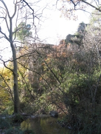
Chateau Tholonet "Barrage Romain" - large aqueduct bridge
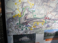
Turn off the D17 at Château Tholonet into the Chemin de la Paroisse and park on the dirt track that runs up the mountain to the NW. Note: this is the next road to the right
after the entrance of the Château. Here is a map with walking routes; walk up a steep track to the east in the direction of the 'barrage romain'. At the top of the track,
where it starts to run horizontal just before a descend into a side valley, remains of a masonry wall in petit appareil are visible along the north side against the mountain slope:
this is a wall that supported the aqueduct channel. Just where the track starts to descend again, a small rock-cut is visible behind some trees in the top of the limestone cliff:
the channel was probably constructed in this rock-cut, but nothing remains.
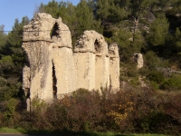
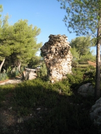
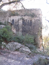
The most important structure of the Saint Antonin aqueduct are visible in the gorge into which the track now descends. Although trees partly obscure the view, it is possible
to see two spectacular concrete masonry-faced walls that once formed the lower part of a large aqueduct bridge. This is commonly mistaken for remains of a dam, therefore
the local name of "barrage romain". Put-holes are preserved in the wall, and at the foot of the wall, rock cuts may have served to support a first arch. The walls probably
supported a tier of arches, since remains of the specus lie on top of the highest visible rock on the west side above the bridge. The top of the bridge must have been 40m
above the level of the creek. The small dam upstream from the bridge and the rock-cut channel at the base of the eastern wall are not Roman, but were built to water
the gardens of the nearby castle. Notice: be very careful, slippery rocks and a deep canyon!!
C.W. Passchier
Aix-en-Provence - AQUAE SEXTIAE
| Item
| Info
|
| Length |
km |
| Cross-section |
m x m |
| Volume |
m3/day |
| Fall |
% |
| Period |
Augustan |
| Features |
|
| Recommended literature :
|
- Ph. Leveau: Les aqueducs d'Aquae Sextiae et la gestion de l'eau sur le territoire de la cité (in Carte Archéologique de la Gaule vol 13/4 (2006) pag 93-109)
|
| Recommended website :
| non
|
| How to visit :
| see above
|