Alcanadre (Spain)

Roman aqueducts: Alcanadre near Lodosa (Spain) Alcanadre near Lodosa (not Roman)
For the photo's, see below
Home / the complete website

"The aqueduct of Alcanadre is part of a very ambitious work, whose unknown designer did not hesitate to go to the left bank of the Ebro to catch the flows and the level needed at the right bank."

The place name Alcanadre

"The place name Alcanadre, also applied to the river Alcanadre, a tributary of the river Cinca in Aragon, and comes from the Arabic al-Qanatir, plural of al-Qantara, "the bridge", which means "the bridges", "the arches", "the aqueduct", according to Materiales para el estudio de la toponimia arabe (Materials for the study of Arabic place names), by Elfas Teres; Madrid, 1986; pag. 217). The Rioja's town of Alcanadre owes therefore its name to the aqueduct in its vicinity, known as "Puente de los Moros" (Moors' Bridge). It indeed crossed the Ebro, and the place name is Arabic as the ancient street layout of Alcanadre, formerly round-shaped".

Object of the aqueduct

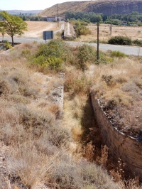
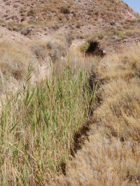
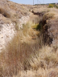
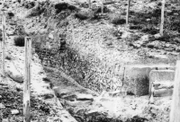
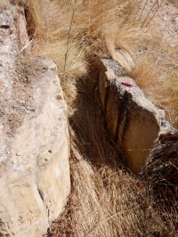
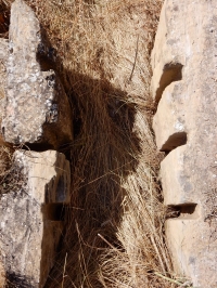
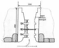
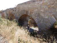
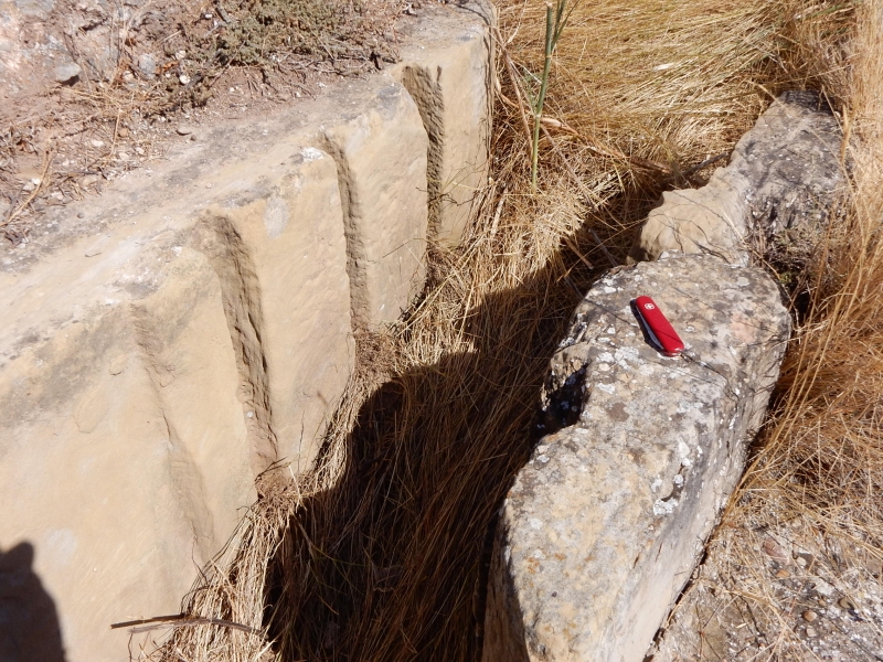
View on the NW side of the sluice gate. The first and third groove were intended for wooden planks to regulate the water flow; the middle, smaller grooves probably hold a filter screen.
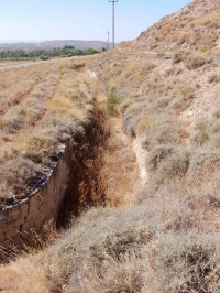
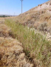
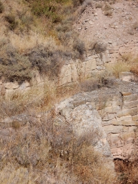
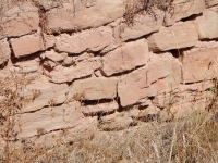
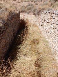
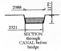
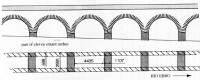
"The grand Iberian river's crossing was part of a work of extraordinary ambition, designed to transfer water from left bank of the Ebro to the right bank, as the Romans did in Caesaraugusta. Tentatively it was supposed that this bridge was part of the water supply to Calagurris, although its level invalidates this hypothesis. Now, after the discovery of San Julian's aqueduct feeding Calahorra in Roman times, an agricultural purpose is proposed, given its considerable cross-section (a specus of 1.50 m), and the resulting flow capacity of 2,88 m3/s (250.000 m3/day), according to Mezquiriz, which is considerable".

Origin of the channel

"The water came from the Sierra de Codes shortly downstream of the confluence of the rivers Linares with the Odron, near Lazagurria (Navarre), where the term "El Charca" (the puddle) seems suggestive. In addition, ancient stones have been discovered embedded in the concrete of a modern weir, see Mezquiriz.
The channel ran parallel to the northern margin of present day road NA-134, entering La Rioja. After some hectometers, the channel - 2,0-2,5 m wide and 1,5 m deep - describes a 90 degree turn to the right, crosses the NA-134, and points towards the Ebro, to where now lies the left abutment of the weir of the modern Canal of Lodosa for irrigation"

Just after the 90 degrees turn, there is the start of a quite interesting branch line of the aqueduct, equipped with three sets of grooves. The object of this branch may have been to divert the water during maintenance of the bridge. Another option is the use of a part of the supplied water for a villa or irrigation on this side of the Ebro river. A double set of grooves in (Roman) aqueducts is not unusual, like in the water supply lines of Metz and Nimes in France. A triple set is unique. It has been hypothesized that the middle set of grooves were used for a filtering screen.

"Thirteen arches are still standing over about 80 m, and the pillars of the ruined arches over another 320 m. They define a straight alignment from the road above, to the shore of the Ebro at about 520 m of the aforementioned turnabout of 90 degrees. According to Mezquiriz, an unknown number of arches were blown up in this last stretch, its stones to be reused in the works of the Canal of Lodosa".

The crossing of the Ebro and the layout on the right bank

Maria-Angeles Mezquiriz, who excavated at both abutments of the disappeared water bridge, dated this work between I to II c. BCE. Given the different sizes of the stones and the poor quality of the masonry work, present scholars date the channel and the bridge now in the very Late Roman period or even later.

"On the right bank of the Ebro are left the remains of an arch of the aqueduct which permits an estimate of their total number in one hundred and eight, supposing them all of the same span (4.80 m)".

Technicalities

Channel before the bridge
- Width on the bottom 2,52m
- Width on the top 2,99m
- Maximum height 1,18m
- Estimated water level 0,90m
 
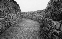
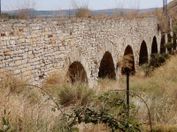
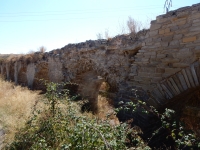
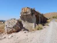
The bridge in numbers
- Estimated number of arches 118
- Of which still standing 11
- Length of the bridge 600m
- Width of the specus on top 1,82m
- Width of the parapets 0,59m
The support of the bridge
- Span of the arches 4,44m
- Width of the pillars 1,10m
- Width of the structure 2,99m

From: Leather 2002

The present 13 standing arches have been variously repaired but the several overturned arches show that the bridge is of a yellowish ashlar work shuttering a course concrete core. "The height of 5 m of this arch would be necessary to make up with the structure of the left bank of the Ebro. At the foot of this remains is the modern catchment weir of the Canal of Lodosa, which was built between 1915 and 1935, but whose extension to Aragon dates after the war 1936-1939.

But the ancient channel ran to a quite higher level, so it would have dominated areas that Canal of Lodosa (total length is 127 km; the flow rate in the channel is 29 m 3/s) cannot serve by gravity".
"The remains of the aqueduct south of the Ebro were affected by the construction in 1863 of the railway Calahorra via Alcanadre to Logrono, that describes here a closed curve, sandwiched between the Ebro and the escarpment on the right bank.
Archaeological findings in different sections of the aqueduct, which followed a path substantially parallel to that adopted later on for the railway, were published in Mezquiriz (1979)".

Wilke D. Schram
Mainly based on the relevant text of the Heliopolis / Lirgua website (Jose-Carlos Abadia Donaque) with alterations and supplements.


Alcanadre near Lodosa

Item Info
Length Unknown
Width on bridge 1,82 m
Volume Unknown
Gradient Unknown
Period post-Roman
Features Sluice gate (plus
filter?) in branch


Recommended literature :
  • J.-C Abadia Donaque: Heliopolis, Roman aqueducts in Hispania, V-2 paragraph 1 Alcanadre (on the web http://www.lirgua.com/ )
  • G.M. Leather(2002): Roman aqueducts in Iberia
  • M.A. Mezquiriz Irujo (1979): El acueducto de Alcanadre - Lodosa (in: Trabajos de arqueologia Navarra vol 1 (1979) pag 139 - 148)
  • E. Sanchez Lopez and J. Martinez Jimenez (2016): Los acueductos de Hispania, construccion y abandono ((only ?) from the web)
Recommended websites   :
How to visit                  : 
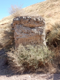
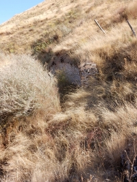
A part of the channel, the sluicegate, and the main part of the aqueduct bridge can easily be found 3km west of Lodosa along the NA-134 from Lodosa to Mendavia.

The southern / right abutment of the aqueduct bridge on the other side of the river Ebro, can be found taking the dirt road at right from the roundabout just outside Lodosa at the right bank of the Ebro river. When you reach the Canal of Lodosa, take one of the bridges, follow the canal and at the end of the road park your car / bike there. Take the tunnel under the railways and turn right. Coordinates: 42 24 59N, 02 06 18W

HOME More literature on more aqueducts Last modified: November, 2016 - (webmaster)


Downstream view

During excavations

Present state

First remains

Downstream view

Culvert

Continuation

Poor masonry work

After the turn

Turn plus sluice

Cross-section

Sluice gate SE

Sluice gate NW

Top view

Plan of the sluice

Grooves in the floor

Aqueduct bridge

Bridge dimensions

Cross-section

13 remaining arches

Poor lining

View on the core

Last arch

SE-side of the Ebro

SE abutment

Cross-section

Continuation