Almuñécar (Spain)
New Document
Sexi Firmum Iulium
Almuñécar lies on a prominent headland between two rivers Rio Verde and Rio Seco along the steep southern coast of Spain, and was settled early.
Phoenician occupation of the site, Sexi, has been proven from the 9th century b.c. In Roman times, the city was a municipium with Latin rights
known as Sexi Firmum Iulium. The main local industry seems to have been the production of garum.
The aqueduct of Almuñécar is only 8 km long, but is one of the nicest aqueducts in Spain since it originally had most of the elements
an aqueduct can possess; the main channel with its manholes and shafts, several small and four major aqueduct bridges of one or two tiers,
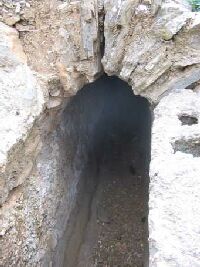
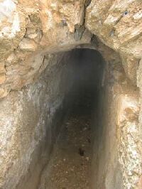
a 350m long tunnel, and a siphon section just outside the town. The aqueduct dates from the first century and was probably mainly built
to support the fish-sauce industry of the town. The upper parts of the aqueduct are still in use water can still be seen dripping out of
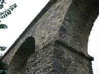
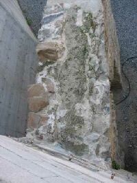
some of the roman aqueduct bridges! The aqueduct is not built from nicely worded ashlars, but from local mica schist, which has a
well-developed cleavage and can only be obtained in small fragments. It is quite poor material to work with, except as filling in concrete,
and it is remarkable that the aqueduct bridges have stood so long with such poor building material. However, it may be that sections have been
repaired or rebuilt, which is also difficult to recognise in this material.
 |
|
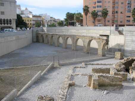
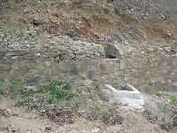
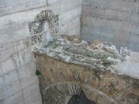
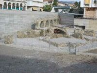
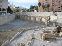
A nice part of the siphon section of the aqueduct of Almunecar are the two parts of a one-tier bridge that was discovered some years ago,
completely buried by the sediment of the Rio Verde. It can be seen from the road that leads north from the central square at the east side,
together with the ruins of a small bathhouse. This section of arches lost the specus, but some of it is visible against a supporting wall on the south side.
|
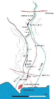
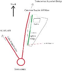
The sources of the aqueduct are unknown, but are probably north of the motorway in a section known as La Angustura in the Rio Verde valley.
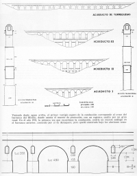
The known section of the aqueduct starts just north of Torrecuevas. Casado (1972) studied the aqueduct in the 1930s and was able then to
make out many structures which are not visible now, including some walls, bridges and part of the ramp of the siphon section (these elements
are indicated in green on the map).
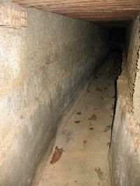
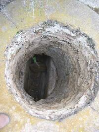
The aqueduct channel is mostly buried and has a specus of 50 cm wide and 75 cm high, covered by a vault. The specus walls are 45 cm thick,
and the vault 30 cm. There are round and square maintenance shafts at regular intervals of about 100m with an internal diameter of 85 cm.
Such shafts occur at each side of the aqueduct bridges, with a depository basin of 90 cm deep at the bottom of the shafts. The tunnel has
dimensions of 170 x 70 cm (Casado 1983).
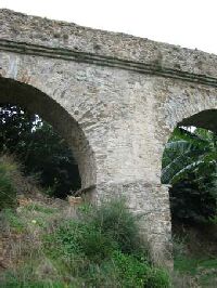
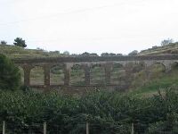
The northernmost presently visible element of the aqueduct is a low bridge just north of Torrecuevas in the valley of the Rio Verde a few
metres east of the road. This bridge can be reached by taking the road to Granada from Almuñécar. The bridge is known as the Torrecuevas aqueduct.
Parking is possible in the barranco west of the road. The bridge has 19 arches, with piers of 6 roman feet square and 17 arches with a
span of about 15 feet, while two have 10 feet spans. There are high-water openings in the upper parts of the piers of this aqueduct.
At the northern end, water could be tapped from the main channel through a small tube (visible below the house that is built along side
the northern part of the bridge). This aqueduct bridge is still carrying water in the specus, now used for irrigation.
The second section of the aqueduct is visible in the Rio Seco, which can be reached from the central square along a road that heads NW.
Just south of the bridge that carries the main road over the Rio Seco, it is possible to drive into the river bed, which is dry most
of the year and accessible with a normal car.
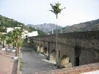
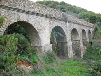
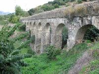
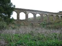
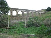
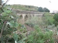
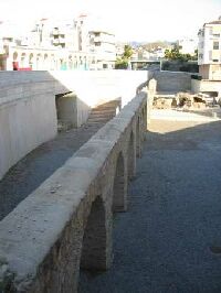
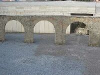
Three major aqueduct bridges are visible along the Rio Seco, but they are poorly visible behind the trees in the plantations that flank the road.
The aqueducts are labelled A I, A II and A III from north to south. This section of the aqueduct is also still used,
but has a metal pipe in the specus, and taps giving access to it at regular intervals.
A I has six arches with five piers of six roman feet square with a square maintenance shafts at both ends.
A II has nine arches and maintenance shafts on both ends. The three central arches have small subsidiary arches between the four supporting piers.
Since the main piers are continuous, they do not define a separate tier.
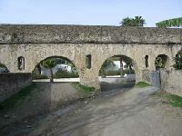
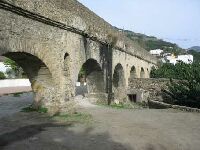
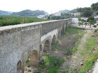
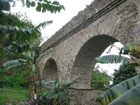
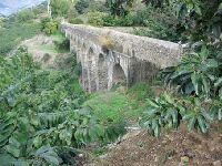
A III has two tiers and is 90 m long. And a total height of 17,5 m. The lower tier has three arches and lateral walls,
while the upper part has11 arches. The lower tier supports six piers of the upper tier.
The final part of the aqueduct to the town must have been a siphon 38 m deep and 1100m long. Casado (1972) and Grewe (1988) report
a small circular basin 420 cm in diameter, covered by a copula that may be of more recent age, which may have been the header tank
of the siphon section. Casado (1972) also identified part of the siphon ramp heading down from this tank towards the town.
This part is no longer visible. According to Casado, the siphon was a ceramic tube, 15 cm in diameter which was partly protected in a
gallery of 70 x 170cm, although Grewe (1988) shows a photograph of the ceramic pipe near the church of Almuñécar, protected in concrete.
A nice part of the siphon section of the aqueduct are two parts of a one-tier bridge that was discovered some years ago, completely buried
by the sediment of the Rio Verde. It can be seen from the road that leads north from the central square at the east side, together
with the ruins of a small bathhouse. This section of arches lost the specus, but some of it is visible against a supporting wall
on the south side; the structure seems to support Casado's claim that the siphon was protected by a gallery. Two of the piers are
ornamented with pilasters, and it is thought that the roman coastal road passed through the arch flanked by these piers.
This part of the aqueduct must have been part of the siphon bridge.
Nothing is presently know about the final section and castellum aquae of the aqueduct, but Casado (1983) claims that the receiving tank of the
siphon may have been a pyramidal structure in the upper part of town, probably destroyed in the 16th century, but described by Arab sources.
In all, this is a very interesting piece of engineering most of which, however, is difficult to access and partly threatened by
recent construction work. During my visit to the aqueduct in 2004, for example, a large new apartment building was going up directly
south of the most beautiful aqueduct, A III. It is to be hoped that the local authorities will see the value of this piece of engineering,
protect it in a proper way, and make the interesting parts better accessible for the public. Clearly, this is potentially a
major tourist attraction if accessible and well explained!
C.W. Passchier
Almuñécar - SEXI FIRMUM IULIUM
| Item
| Info
|
| Length |
8 km |
| Cross-section |
0,5 m x 0,75 m |
| Volume |
m3/day |
| Gradient |
% |
| Period |
first c AD |
| Features |
- specus and manholes
- several aqueduct bridges
- tunnel
- siphon
|
| Recommended literature :
|
- C.F. Casado (1972): Acueductos Romanos en España
- C.F. Casado (1983): Ingenieria Hidraulica Romana
- K. Grewe (1991): Die römische Wasserleitung von Almuñécar (Sexi) (in: Antike Welt 1991 pag 49 ff)
|
| Recommended website :
| Visitors guide Almuñécar (Sexi) |
| How to visit :
| see text above
|