Aspendos (Turkey)
Roman aqueducts: Aspendos (Turkey)
ASPENDOS
Aspendos was a small Greek town in Pamphilia, now in southern Turkey. It was built on and around a small oval flat topped hill not far from
the coast and from the main coastal highway. The town had a river harbour on the Eurymedon river (now called the Köprü çay ) which washed
the hill on the east side, and which was navigable up to the town. A major road bridge in the coastal highway crossed the Eurymedon just
south of town. The town prospered in Roman times, with a maximum population of about 20.000.
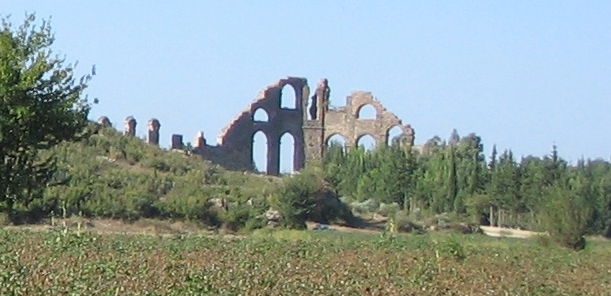
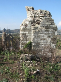
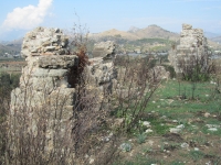
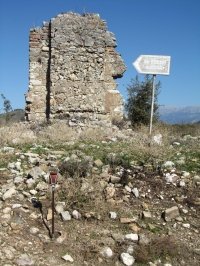
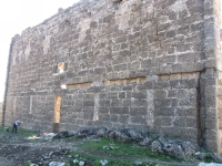
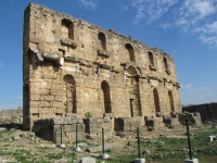
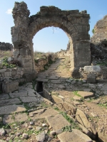
Aspendos is now a ruin site of great importance. It has never been excavated, and only two buildings are visible on the acropolis hill,
both standing up to 15 m high; the ruins of the entrance hall to the Roman Basilica and a remaining wall of a nymphaeum (monumental fountain).
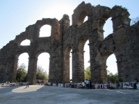
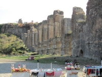
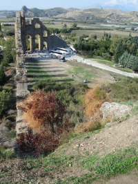
Aspendos is most famous, however, for its roman theatre built in the eastern slope of the hill, one of the best preserved theatres
of the ancient world, and almost undamaged except for the missing columns and wooden covering of the Scenae Frons.
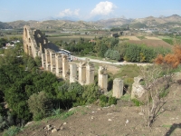
Less well known, but possibly more important than the theatre, is the unique aqueduct of Aspendos.
The aqueduct
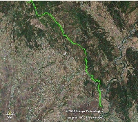
The aqueduct of Aspendos transported water from the hills to the north to the town over a distance of 19 km. There are two sources,
the Gökçepinar (pleasant spring) at 550 m, with a discharge of 30-40 l/sec and the Pinarbas i (springhead) at 440 m,
with a discharge of 40 l/sec. The Aspendos acropolis lies at 60m above sea level, so that the aqueduct has a mean slope of 26 m/km.
The aqueduct is the usual assemblage of a buried masonry channel and an array of bridges and tunnels. The channel is mostly
0,60 m wide and 0,90 m high (two by three roman feet) with walls 0,40 m thick. Remains of several bridges and tunnels can be observed along its course,
as mentioned below. The main importance of this aqueduct, however, lies in the last 2 km of the conduct, immediately north of the
acropolis hill of Aspendos. Here are the well-preserved remains of the Aspendos inverted siphon which made this aqueduct famous.
The siphons
 |
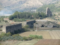
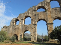
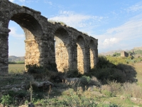
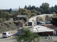
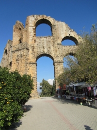
The inverted siphon of the Roman aqueduct of Aspendos is 1670 m long and crossed a wide and originally swampy flat valley between the hills and the town.
The inverted siphon is unique in the roman world because of its state of preservation, and because it was split into three venter bridges,
of 592, 924 and 154 m long, separated by two towers where the water ascended and descended, and which are today still 30 m high.
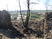
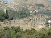
Here the south tower of the siphon.
|
The inverted siphon is 1670 m long and crossed a wide and originally swampy flat valley between the hills and the town.
The inverted siphon is unique in the roman world because of its state of preservation, and because it was split into
three venter bridges, of 592, 924 and 154 m long, separated by two towers where the water ascended and descended,
and which are today still 30 m high.
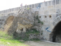
Each of the towers lies at a bend in the inverted siphon. The tower structures are very similar and are known as the
north and south towers. Each structure has ramps 2,4 m wide with a number of arches, which run up to the top a central tower 5,5 m square.
This central tower has a door and slit-like windows, and contains a spiral staircase that went up the full height of the tower.
The towers were originally higher, but nothing is known of the upper part of the structures. The lower part of the towers is built
of conglomerate blocks, and the top part of brick.
The northern section of the inverted siphon between the header tank and the north tower consisted of a steep ramp down from
the header tank on a flat topped hill just north of the village of Sariiabali, and an arrangement of walls 2,4 m wide and
an originally 5 m high venter bridge of 11 piers. Eight piers of 3 m high are still standing.
The piers are 2,4 x 2,5 m square separated by arches of 4,5 m.
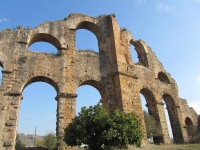
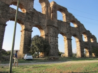
The section between the north and south towers contained a long venter bridge of 46 arches of a single tier up to
15 m high, 29 of which are still standing in groups of 8, 11 and 10 arches. This venter bridge was built of blocks of conglomerate,
2x2x5 roman feet. Slabs of conglomerate 5,5 to 5,7 m wide cover the bride and protrude 0,20-0,30 m over the edges. The arches are
7 m wide and the piers 3,6 x 5,4 m square.
The third venter bridge is considerably higher than the other two and consisted of 14 piers 2,4 m square. It was built as a two tier bridge
of double arches, of which only one arch has been preserved. Secondary arches connected the lower parst of the first ten piers,
while the remaining four did not need them since they were built on the slope of the acropolis hill of Aspendos.
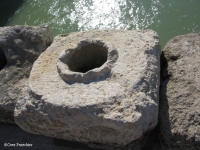
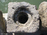
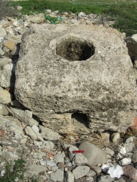
The actual pipes of the inverted siphon consisted of over 3400 perforated blocks of limestone laid out on venter bridges and walls,
and sealed with a mixture of lime and olive oil, which expands when it gets wet. The limestone was locally quarried on the east side
of the Eurymedon. The blocks of the siphon have dimensions of 0,86 x 0,86 x 0,50 m, or 0,90 x 0,70 x 0,70 m. Few blocks are left near the aqueduct,
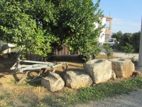
but some can be seen in and near the Seldjuk bridge over the river south of town.
The inverted siphon was up to 40 m deep on venter bridges up to 15 m high, leading to a pressure of 400kPa (4bar) in the pipes.
The difference in altitude between the header tank on the hill and the receiving tank in town at the end of the inverted siphon bridge
was 14,5 m, a slope of 8,7 m/km (0,87%). The capacity of the inverted siphon was to deliver about 65 l/sec, or 5600 m3 per day,
about what both springs deliver at present.
Dating
The aqueduct was probably built in the second half of the third century, and certainly between the middle of the second and end
of the third century. An inscription was found stating that one Tiberius Claudius Italicus spent 2 million denarii to build
an aqueduct at Aspendos. The aqueduct seems to have had an active life of no more than 150 years. This is indicated by the thickness
of sinter in the aqueduct, but also by another curious fact. The Seljuk bridge over the Eurymedon, south of Aspendos had a roman predecessor.
This roman bridge is partly built of perforated limestone blocks from the Aspendos inverted siphon ! This probably means
that the aqueduct was so severely damaged that repair was out of the question, and that the blocks were therefore free to be used
on the bridge. Possibly, both the bridge and the aqueduct were damaged in a earthquake. If the towers in the inverted siphon
carried water tanks, they would have been very vulnerable in an earthquake, as anyone knows who has seen the behaviour of buildings
with water tanks or swimming pools in their top stories.
The towers
The two towers with lateral ramps leading to the top in the inverted siphon are the most impressive, but also the most curious aspect
of the aqueduct. Why were they built? At present, the top is missing, so not much can be said with certainty.
It is possible that each tower carried a basin open to the air on the line of the hydraulic gradient of the inverted siphon.
It is conceivable that an inverted siphon made sense in a valley of more that 50 m deep and over a kilometre long, but could it
not have functioned without the towers? The towers are situated at two bends in the aqueduct, and it has been suggested that the towers
were needed to avoid damage due to 'water hammer' in those bends. However, these sharp bends do not seem to be necessary;
a straight or gently curved course would also have been possible. It is therefore more likely that the purpose was to break up
the aqueduct in segments that could be drained and repaired individually, to reduce the problem of water hammer in the inverted siphon,
or to remove air from the system. If the towers carried tanks open to the air, they would have been over 40 m high.
Alternatively, they were not open at the top, but contained a structure where water and air could be released from the pipes at reduced pressure.
Text and drawings Cees Passchier
Photo's Wilke Schram (2012)
Visible remains
- Spring of Gökçepinar (only the spring, no remains of structures)
- 7m long stretch of the floor of the specus in a section with a slope of 20 m/km
- Tunnel shaft (2,7 m square). No other remains of tunnel but it may have been 550 m long
- Tunnel shaft 2,7 m square. No remains of tunnel
- Spring of Pinarbas i (remains of the triangular spring house of 5 x 2 m, with one roof-slab remaining. The aqueduct channel is 0,50 m wide here. Nearby remains of possible other caption structures.
- Floor of the specus in a steep section of the aqueduct (160-170 m/km
- Remaining 8m high pier, 2 x 2 m square, of a three pier bridge over the Kisl Dere stream.
- One remaining arch of a 125 m long and 20 m high two-tier bridge over the Kisil Dere. The central part of the bridge, with lower arches over the stream and remains of piers of the upper arches were standing till the end of the 1980s. Apparently, there were remains of an inscription on the bridge but this has now been lost.
- Tunnel shaft
- Remains of the specus and its arched vaulting in the slope
- One remaining 5 m arch of a bridge 23 m in length
- Collapsed remains of a 50 m long and 15 m high two tier bridge
- Cross-sections of the aqueduct along the side of the modern waterway
- Exit and entrance of a tunnel, 1,6 m wide and 1,9 m high
- Entrance of a second tunnel. Exit cannot be found
- Remains of the header tank (HT)
- 8 piers of a low venter bridge
- North tower (NT)
- Central venter bridge
- South tower (ST)
- Piers of double-tiered venter bridge
- Remains of pier supporting the receiver tank (RT)
Belkis - ASPENDOS
| Item
| Info
|
| Length |
19 km |
| Cross-section |
0,6 m x 0,9 m |
| Volume |
5.600 m3/day |
| Gradient |
2,6 % |
| Period |
150 - 300 AD |
| Features |
|
Literature used
- Fahlbusch, H. 1987. Aspendos. In: Die Wasserversorgung antiker Städte II. Von Zabern, Mainz.
- Kessener, P. and Piras S. (1998a). The pressure line of the Aspendos aqueduct. Adylya II, 159 - 187.
- Kessener, P. and Piras S. (1998b). The Aspendos aqueduct and the Roman-Seljuk bridge over the Eurymedon. Adylya III,149 - 168.
- Kessener, H. P. M. (2000). The aqueduct at Aspendos and its inverted Siphon. American Journal of Archaeology 13, 105 - 132
- Ortloff C. R. and Kassinos A. (2003) Computational Fluid Dynamics Investigation of the Hydraulic Behaviour of the Roman Inverted Siphon System at Aspendos, Turkey. Journal of Archaeological Science 30, 417 - 428
| Recommended literature :
| Kessener, H. P. M. (2000): The aqueduct at Aspendos and its inverted Siphon. Journal of Archaeology 13, 105 - 132
|
| Recommended website :
| Aspendos (and Perge)
|
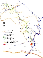
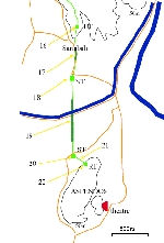
| How to visit :
| see maps below
|