Humeima/Auara (Jordan)
Roman aqueducts: Humeima (Jordan)
Humeima - AUARA
Ancient AUARA, Humeima - on the Peutinger Map indicated as Hauara, approximately at equidistant between Aqaba en Ma'an - was a small trading post and caravan way-station
in Edom, Jordan. This major Nabataean center in the Hisma, Jordan's southern desert, was founded by the Nabataean King Aretas III in the 80s B.C. as, to serve as a center for
sedentarisation of the local nomadic Nabataean shepherds at a time when regional trade routes were shifting elsewhere, and as a strategy of state formation by a developing monarchy.
Through careful management of the meager spring water and precipitation, the community was able to enjoy a settled existence based on agriculture, stock-raising, and
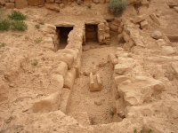
passing caravans. Soon after the Roman conquest of the Nabataean kingdom in 106 AD and formation of the Provincia Arabia, Trajan's forces built a major fort at the site
to administer this region and suppress any local resistance. A modest prosperity continued through the Byzantine and early Islamic periods, until the site was abandoned
around 750 A.C.
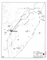
The settlement is located at the conflux of several run-off fields that provide a reliable supply and manageable amount of water to two public reservoirs and numerous
private, domestic cisterns. Furthermore, it sits at the southernmost point that could conveniently be reached by a gravity flow aqueduct fed by springs on the escarpment
15 km to the north, and it is near good agricultural soil and a route to the Wadi Arabah. The scale of the first-century B.C. or A.C. public reservoirs and aqueduct
indicate central, probably royal, planning and sponsorship.
The aqueduct
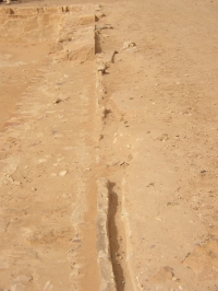
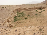
The aqueduct is a great example of Nabataean hydraulic skill. Built in the first century BC it consisted of a main line 18,9 km long, from the 'Ain al-Qanah at an elevation
of 1425 m to the Nabataean reservoir in the city center at 995 m. A branch line of 7,625 km connected the springs of 'Ain ash-Sharah and 'Ain aj-Jamam with the main line,
joining at 6,557 km downstream from 'Ain al-Qanah. This branch was furnished with 6 settling basins.
The main line - 0,12 m wide and 0,14 m deep - followed the ground level and occasionally made use of bridges and viaducts. The maximum possible flow was 150 m3/day,
the overall slope 2,45 %. However, the level of the slope varied from less than 1% to 20% and at the ash-Sharah escarpment even 45 %.
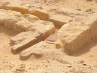
The aqueduct consisted of a heavy rubble foundation wall that supported the long stone conduit blocks framed by rubble packing set in mortar. The conduit blocks were made of
yellow marl or white sandstone depending of the region; the material was quarried locally. On the upper edges of the conduit blocks fist size rubble was set in hard mortar and
smoothed over with stucco/plaster on the interior. The whole structure was topped with flat slabs of limestone. This is a typical Nabataean technique, with parallel cases
found on almost all Nabataean sites, although the 'Ain al-Quanah is the longest aqueduct by far.
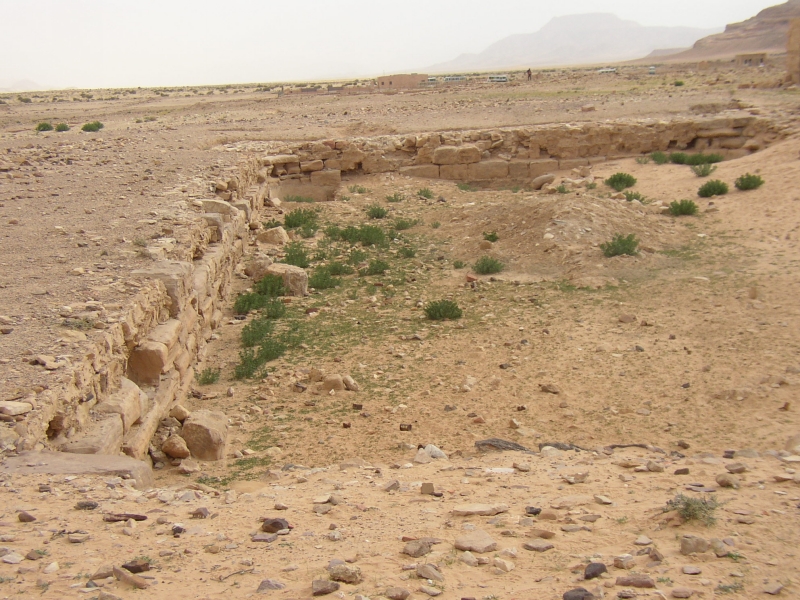
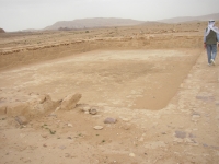
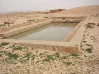
Roman reservoir
 |
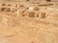
|
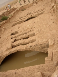
Roman reservoir within the Roman fort of Humeima / Auara, Jordan, view to the NE measured exactly 100 x 50 x 10 Roman feet (capacity 1250 m3).
This basin was fed by the ‘Ain el-Qanah aqueduct which entered the reservoir from the NW but here ploughing had obliterated all traces of the 100m long conduit
to the intersection with the main line.
|
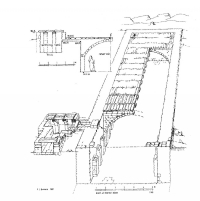
The large Roman fort at the N edge of Auara is one of the most prominent features at the site. The rectangular plan of the fort with a gate in each of the four walls, measured
500 x 700 Roman feet (206 x 148 m), the reservoir in its NW corner (100 x 50 x 10 Roman feet; 29 x 14 x 3 m) had a capacity of about 1250 m3, presumably built in the same
period as the fort.
The aqueduct entered the fort from the NW. The distance to the presumed intersection with the main al-Qanah aqueduct is about 100 m but here ploughing had obliterated
all traces of the aqueduct conduit. At the SW corner remains of another sandstone conduit slab suggest a continuation of the water in the reservoir to a place more close
to the inhabited areas. The further absence of any arrangement for handling overflow from the reservoir suggests that the main aqueduct line did not terminate in the
Roman reservoir but continued S of the Nabataean reservoir.
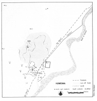
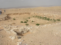
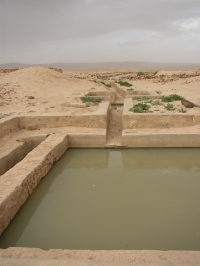
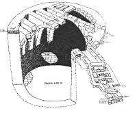
Nabataean reservoir
The second reservoir was placed on a ridge 6 m above and 350 m NE of the settlement center / 75 m W of the fort, and was designed to be fed by the al-Qanah aqueduct
and was of Nabataean design, half so deep as the Roman one. It measured 27,5 x 17 x 1,75 m (capacity 800 m3) and was made waterproof by a layer of hard, white sandy plaster.
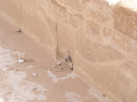
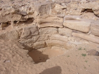
The aqueduct entered the reservoir in the middle of the N wall. The overflow was at the W end of the S wall (zie photo), about 1,35 m over the floor of the reservoir,
could be stopped by means of a slot cut in one of the wall blocks. Thereafter the water was led into a conduit of mark blocks identical to the ones used in the al-Qanah aqueduct
and could be traced for 85 m to the S. Originally there must have been a kind of basin on the place the water left the reservoir. At a later date the basin was removed
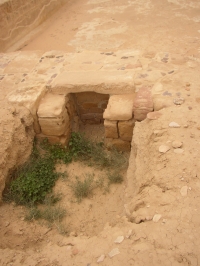
and the conduit replaced by a bronze pipe cut through the wall at the level of the interior floor (see photo). The flow was regulated by a massive bronze stopcock (precisely
measuring 1 Roman foot in length) after which the water was brought into a (pressurized) lead pipe (outside diameter 0,05 m) laid in the conduit channel, in the direction
of the small bath building (2nd c AD), 100 m S of the reservoir. Still later, the lead piping was roughly replaced, the valve plugged with mortar and the reservoir
by-passed by a terracotta pipeline (diameter 0,082 m).
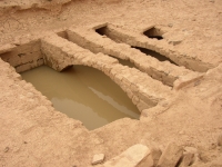
Cisterns
Apart from the reservoirs, there were 11 (private ?) cisterns inside the settlement and 51 more in the surroundings. The houses seemed to have been laid out around
two larger ones, identical in design and built at right angles to each other, with capacities of 445 and 487 m3, both roofed with flat stone slabs carried by 16 transverse arches,
20 m apart en 50 m W of a funnel-shaped depression that allow them to harvest the water run-off of the large, gently-sloping fields that spread out over approximately
100 ha N of Auara.
One cistern (67) was filled by a 25 m long intake channel, which was rebuilt in the 1960's including a settling tank. The other cistern (68) is still in condition and was also
refurbished with an intake channel and a deep settling tank (3,18 x 2,58 m; 1,6 m below the floor of the intake). Oleson suggest that a municipal authority built them, for public use. The other ones - mostly of circular shape - had a capacity less than 200 m3 each, were for private use and built by individual families, according to Oleson.
The cisterns with their dependable water supply would have attracted some permanent inhabitants, while the fresher but also more vulnerable supply of aqueduct water
might have been intended to service both caravans using the Nabataean north/south road and nomadic or semi-sedentarized Bedouins drawn to the site for occasional
trade or seasonal agriculture.
(mainly based on numerous reports of prof. J.P. Oleson)
W.D. Schram
Humeima - AUARA
| Item
| Info
|
| Length |
18,9 km |
| Cross-section |
0,12 m x 0,14 m |
| Volume |
150 m3/day |
| Fall |
2,45 % |
| Period |
1 c AD |
| Features |
- Nabataean origine
- 6 settling tanks in a tributary conduit
- max fall 45%
- two major basis: one Nabataean, one Roman
|
| Recommended literature :
| see website of prof.dr. J.P. Oleson.
|
| Recommended website :
| Non. About Nabataean water supply and concrete see separate website
|
| How to visit :
| Difficult to reach. Fourwheel-drive and GPS necessary. At own risk.
|