Baelo (Spain)
Roman aqueducts: Baelo Claudia (Spain)
BAELO CLAUDIA
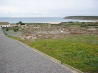
Baelo Claudia is a small roman town on the shores of the Atlantic, west of Gibraltar, where Africa can easily be seen at the horizon.
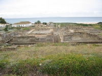
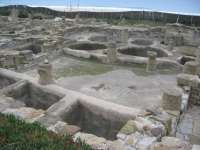
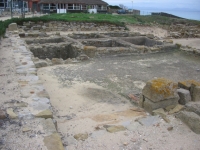
The ruins of Baelo Claudia belong to the most interesting in southern Spain, and give a nice impression of a "complete" small roman town,
including a capitolium with interesting remains of three temples (foundations), a theatre, a macellum (small market), baths, the forum and basilica
and of private houses. The town lies on the sea shore west of Tarifa, at the bottom of a circle of hills forming a shallow comb
only a few kilometres wide. The town had its period of maximum prosperity in the time of Claudius and Nero, and gradually declined
after the first century AD and was abandoned in the seventh century. The site was never rebuilt, and is now only occupied by
the small village of Bolonia, east of the excavations. As such, it is a unique opportunity to excavate a small roman coastal town
in it entirety, complete with roads, aqueducts, and other structures.
Baelo can be reached from the main Cadiz-Tarifa highway (E5-N340) along a narrow country road (CA9004) which is well signposted. The aqueducts can
only be reached on foot.
The town is very small, not more than 400 m wide and 900m long, and surrounded by remains of a town wall.
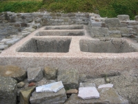
Along the shore, impressive remains can be seen of several factories for the preparation of garum, which was the main industry of the town.
Although a small bathhouse was found in the western part of the town, the garum factories are probably the reason that Baelo
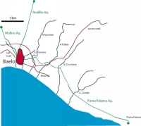
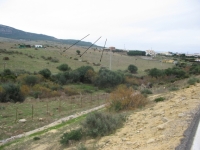
was the proud owner of three roman aqueducts, sizable remains of which can still be seen. They are locally known as the
aqueducts of Realillo, del Molino and of Punta Paloma.
None of the aqueducts has been excavated to date, and many parts are in sore need of restoration or stabilisation.
Two of the aqueducts have unusually steep slopes because of the location of Baelo at the bottom of a short, steep valley.
Because of the steep slope, these aqueducts have interesting structures such stilling basins to reduce the speed and so the
destructive power of the flowing water.
It is to be hoped that in the near future means can be found to restore and preserve this interesting set of aqueducts,
together with their springs, castellae, thermae and the fish-sauce factories.
The Aqueduct of Realillo (A1)
 |
|
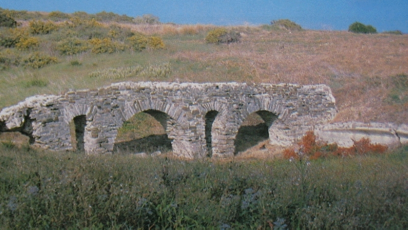
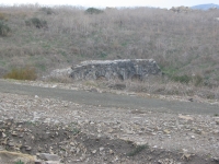
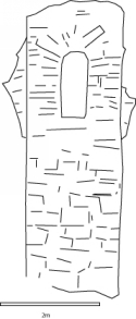
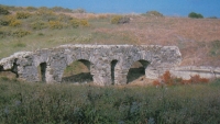
The last bridge of the Paloma aqueduct is a small, well-preserved low structure at the edge of the town on the Cañada de la Chorrera. It is 32m long and still in
reasonable state of preservation, with three arches of 3,87 m wide in the centre to 3,58 m wide for the lateral arches (13 and 12 Roman
feet respectively). The specus is still visible on top, and is 0,42m wide and 0,56m deep. On the east side, there is a cylindrical basin in the
specus, 0,62 cm in diameter, probably meant to retain impurities before the water reached the bridge. About 50 metres to the West
of the bridge, the aqueduct reaches the town wall.
|
This aqueduct runs from an unknown source in the Sierra de La Plata and ends in an interesting basin of 30x6m (el aljibe) in the northern part
of the town, possibly the castellum aquae, which was originally covered by an arched concrete roof.
This structure can unfortunately not be visited by tourists. In fact, only the lower part of the town, around the forum
is open for visitors and most of the upper city has not yet been excavated.
North of the castellum the aqueduct runs underground, but can be localised because of three circular basins with a diameter of 0,8 m,
internally covered with opus signinum. North of the town wall and the new main road that circles the town,
several more basins and parts of the specus can be found up to 400 m from the town. Higher up, no certain relicts exist,
but the source of the aqueduct was probably a spring near the hamlet of Realillo, in the Sierra de la Plata.
The total length of this aqueduct is estimated at 4 km, with a vertical drop of 140 m and a mean inclination of 3,5%.
The gradient is therefore rather steep, and a number of basins along the length of the canal may have served
to reduce the speed of the water in the aqueduct.
The aqueduct of Molino de Sierra Plata (A2)
This aqueduct runs from a source at Molino de la Plata in the Sierra de Plata (Molino de Carriscales)
through a basin at 71m altitude 1200m west of the town wall and ends in the western part of town at an altitude of 6m.
There are some remains along the old road, and the aqueduct probably entered the town between the Porta de Gades and the theatre.
The specus has a width and depth of 0,4 m, and was covered by sandstone slabs of 1.2m long and of semicircular shape.
Several of these have been found reused near the mill in the west. The length is at least 1200m, with a mean inclination
of the known part of the aqueduct of 4,5%. It is likely that the upper part was even steeper, and that the basin mentioned
above served to brake the speed of the flow.
The aqueduct of Punta Paloma (A3)
This aqueduct is the best known of the three aqueducts of Baelo, since there are still several impressive remains along its length.
Its total length is 5550m with a total descent of 54m between the caput aquae at 70 m and the probable site of the castellum
in the town at 16-17m above sea level. This gives a slope of 1%, much less than the other two aqueducts.
The possible site of the castellum has not yet been excavated.
The 'caput aquae' is the spring of Punta Paloma 6 km east of Baelo, which is covered by sand and rocks and now only recognisable
by the nature of the vegetation, directly north of the hamlet of Casas de las Palomas. Unfortunately, the area is now in hands
of the military and difficult to access. About 100m West of the spring, a 50m long section of the specus of the aqueduct can be seen,
covered by curved slabs of calc arenite. The specus is 40 cm deep and 38 cm wide, with walls 38 cm thick, and lined with opus signinum.
From this point, remains of the aqueduct can be observed in Cortijo de la Torre, where a circular manhole can be seen,
and in several brooks (arroyos).
In the Arroyo del Conejo (Arroyo de Puerto Bajo on the 1:50.000 map) there are several remains of an aqueduct bridge,
which originally was 112m long with 16-17 arches of 2,62 to 3,35m wide. A pillar of more than 5m high with a flood release
opening is still standing.In the deeper Arroyo de la Churriana, there are remains of a bridge of 11m high and 76m long.
There were probably originally 9 arches of 4.2m high.
Alongside the Arroyo del Pulido, the specus of the aqueduct can again be observed at the surface, but the bridge was destroyed,
probably when the road was built. From here the aqueduct can be followed to the Arroyo Alpariate alongside the modern road
that leads around the town of Baelo, where a fourth bridge existed, remains of which can be seen in the brook.
The last bridge is a small, well-preserved low structure at the edge of the town on the Cañada de la Chorrera. It is 32m long
and still in reasonable state of preservation, with three arches of 3,87 m wide in the centre to 3,58 m wide for the lateral
arches (13 and 12 Roman feet respectively). The specus is still visible on top, and is 0,42m wide and 0,56m deep.
On the east side, there is a cylindrical basin in the specus, 0,62 cm in diameter, probably meant to retain impurities
before the water reached the bridge. About 50 metres to the West of the bridge, the aqueduct reaches the town wall.
C.W. Passchier
Baelo - BAELO CLAUDIA
| Item
| Realillo
| Molino
| Punta
|
| Length |
4 km |
1,2 km |
5,5 km |
| Cross-section |
m x m |
0,40 m x 0,40 m |
0,40 m x 0,38 m |
| Volume |
m3/day |
m3/day |
m3/day |
| Fall |
3,5 % |
4,5 % |
1 % |
| Period |
|
|
|
| Features |
- 3 individual aqueducts
- stilling basins
- several bridges
|
| Recommended literature :
|
Baelo Claudia. Guía oficial del conjunto arqueológico, Junta de Andalucia 2003;
Baelo Claudia, una ciudad romana de la Bética, Pierre Sillières, Junta de Andalucia, Casa de Velásquez 1997.
|
| Recommended website : |
none |
| How to visit : |
see text above |