Bellegarde (France)
Roman aqueduct near Bellegarde (France)
Bellegarde - PONS AERARIUS
In Roman times, Pons Aerarius was not without importance because of its location along the Via Dominitia, the main route between homeland Italy and Spain.
Its exact location is unknown, it is often situated in the region of Bellegarde - in between Nîmes and Arles.
Visible remains
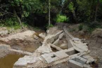
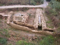
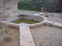
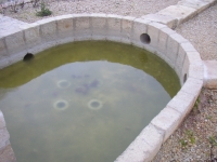
A few hundred meters NW of the Château Laval - 3 km W of the center of Bellegarde - is the caput aquae, the captured source plus collection basin of the aqueduct
of Bellegarde. Already in antiquity, given the many stones and ceramic and cast-iron findings, this place was reconstructed several times.
However, in the CAG 30/2 (ed. 1999. M. Provost) a site close to Mas Sauzette was indicated as the main source of the Bellegarde aqueduct.
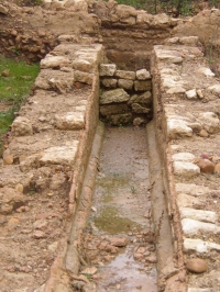
From Laval the subterranean conduit found its way east along the edge of the Costières du Gard. Close to the village center, just north of the road N113 from Arles to Nîmes,
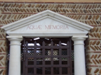
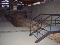
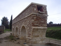
one can find the unfinished 'Musée de l'eau', a roofed hall with partly open walls with some exhibits and outside a nice piece of the vaulted channel including a regard (manhole).
Here the channel headed NE for another 2,5 km, direction Beaucare. In this area one estimate a mean fall of about 0,4% (20 m to 5,3 km) and a discharge of about 15.000 m3/day.
The possible date of construction is somewhere in the second half of the first century. The presence of an aqueduct was already known from a document of 788 AD referring
to a donation by bishop Remessarius in 640 AD, an aqueduct 'ad ipsa arca'.
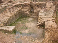
Basin
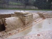
In the area now called Valescure - at the common border of Beaucare and Bellegarde - a conduit branched off with a square angle direction SE. However, the main channel
continued some 8 m in the original direction, made a turn to the south and came to an end in a basin which function is still unclear. There is no indication of any outlet. That makes it implausible that there was any continuation of the aqueduct towards Beaucare, as was thought until recently, contrary to the absence of any findings in this direction.
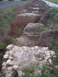
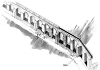
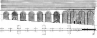
There are no visible remains of the aqueduct channel heading SE towards Contrac; only foundations of some 180 - out of the conjectured 250 - pillars are known.
The estimated length of this up to 8 - 12 meters high arcade - locally known as ′la Draille des Arcs′ is over 1600 m. Every third pillar was enforced by buttresses
on both sides. A real-size model with four pillars is present in the backyard of the water museum, see above.
Puzzle
The major puzzle now is the destination of the aqueduct water. The most plausible option is water for Arles-Trinquetaille although the aqueduct might had to cross one
of the side branches of the Rhône. But this option puts into question the present view that Trinquetaille was (also?) supplied by waters from an extended branch line of the
Arles aqueduct which crossed the Rhône by means of a siphon with lead pipes, as presented in the beautiful Archaeological Museum of Arles. Other options are an extensive
Roman villa in the fertile plains of the Rhône delta, or a water mill complex.
Wilke Schram
Bellegarde - PONS AERARIUS
| Item
| Info
|
| Length |
5326 + 1615 m |
| Cross-section |
1,2 m x 0,55 m |
| Volume |
15.000 m3/day |
| Fall |
0,04 % |
| Period |
1 c AD |
| Features |
- basin Valescure
- manholes (regards)
- museum 'Aquae Memoria'
- destination unknown
|
| Recommended literature :
|
- "Dossier L'aqueduc antique de Bellegarde" as indicated in the second link below
- Fabre and Sauvage 1997: Un ouvrage de grande hydraulique ... Costièreres du Gard (in: bedon 1997)
|
| Recommended websites :
|
|
| How to visit :
| see above
|