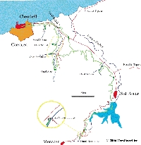
Cherchell (Algeria)
Roman aqueducts: Cherchel / Caesarea de Mauretanie (Algeria)
Cherchel / Caesarea de Mauretanie - IOL CAESAREA
Cherchell, the former city of Caesarea Mauretaniae was the capital of the Kingdom of Mauretania and after 42 A.D. also the capital of a Roman province,
with a town wall that enclosed one of the largest surface areas of any city in the Roman empire. The city has two nice museums, and numerous remains
of its Roman past, such as a theatre, an amphitheatre, baths, a circus, but all unfortunately rather neglected and wedged-in by the rapidly growing city.
Caesarea also had one of the longest aqueducts in Africa.
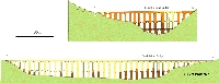
The aqueduct of Cherchell conducted water over a proven length of 45 km from mountains in the South to the city. An inscription found in Cherchell
gives the length as 35000 passi, 35 miles or 51 km. The aqueduct is special because the existing remains show us that Roman aqueducts were not always
the brilliant works of engineering which we imagine when we read about the Pont du Gard or the aqueducts of Rome and Lyon. In fact,
the aqueduct of Cherchell shows that in Roman times aqueducts were subject to human error, and that some problems, especially those of local geology,
could only be solved with great difficulty.
The original and final solution for the Cherchell aqueduct
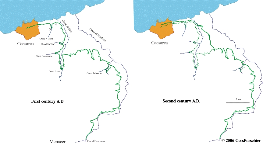
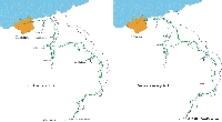
In its first setup the aqueduct was built in the first half of the first century A.D., probably during the reign of Juba II, king of Mauretania
and friend of the emperor Augustus. Initially it was at least 45 km long and ran from springs in the alluvium of the Oued el Hachem river
at 131 m altitude to the city, making a loop to the South around the Oued Bellah valley (Oued = wadi / river).
A smaller loop went for 3 km around the Oued Ilelouine valley in the East. This aqueduct reached the city at an altitude of 40m.
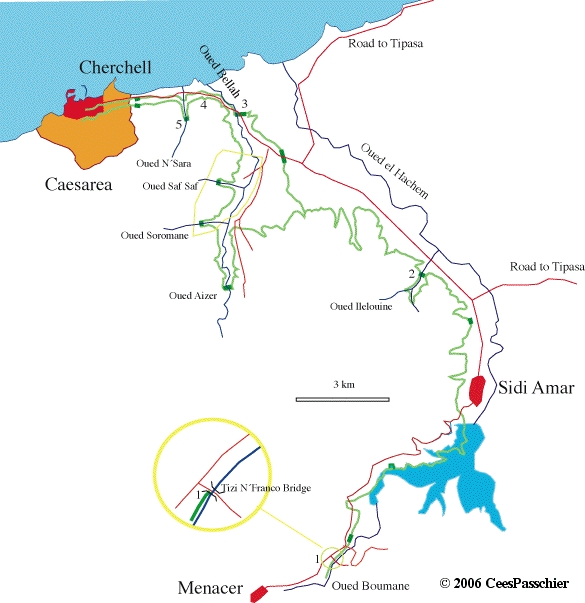
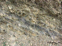
Sometime during the second century A.D., it was decided to make a drastic change. The local geology contains a lot of weak marl and shale,
rocks that are prone to creep and landslide, and some of the least desirable rocks to build on anywhere. Also, the climate is characterized by
dry summers and torrential rain in winter, which makes the danger of soil creep and landslides very high.
The original and final solution for the Cherchell aqueduct
A buried aqueduct channel poses a special problem in such terrain, because it blocks the flow of water in the soil down the slope,
enhancing the danger of landslides. Also, bridges may be affected if they cannot be put on solid foundations, as is very obvious
when investigating the remains of one of the bridges near the city, that over the small creek of Oued N'Sara (see below).
Most likely, the costs of repairing sections of aqueduct that had slipped, and the steady interruption of the water supply brought the engineers
to consider a new trajectory, cutting off the Oued Ilelouine loop by building a new, high bridge in the narrow gorge where it joins the plains,
and building a new, shorter route crossing the Oued Bellah with a high bridge. The old loop in the Oued Bellah valley was abandoned.
The disadvantage of this solution was, that the new aqueduct reached the city at an altitude of 30 m (the former one at 40 m),
so the higher parts of the city could no longer be provided with running water. This solution seems to have worked for some time,
but eventually the Oued Bellah bridge also collapsed, probably because of its poor construction.
Sites to visit
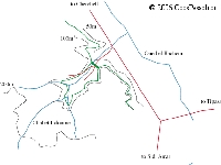
Five bridges of the aqueduct are easy to visit, and I have seen them in December 2006 (Oued - wadi = river):
- the Tisi N'Franco bridge
- the Oued Ilelouine bridge
- the Oued Bellah bridge
- the Ponte Riad bridge
- and the Oued N'Sara bridge
Near the original source of the aqueduct, a short section of the channel can be seen below an old bridge over the Oued Boumane.
Other aqueduct bridges mentioned by Leveau and Paillet are now difficult to find, either overgrown, overbuilt, drowned in the new lake,
or hidden in the military complex of the upper Oued Bellah. We are interested in any reports on survival of these structures.
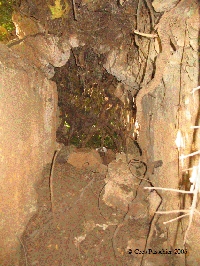
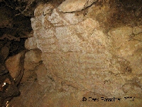
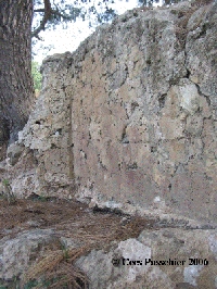
1. Channel-remains below the old bridge on the road to Tisi N'Franco
This is an old steel bridge over the Oued Boukadir at a small bus shelter opposite a steep cliff, two km East of the village of Menacer. The new bridge
is a few hundred metres to the East. The first remaining section of the Roman aqueduct can here be seen on a concrete wall 2 m above the river below
the bridge on the North and upstream side of the bridge. The aqueduct is cut off by the North pillar of the bridge, but is reasonably well preserved,
even with a section of the vault that covered the channel. Interesting is that these vaults in Mauretania were built on a centring covered with reeds,
and impressions of the reeds are still visible in the vault. I think that the reed may have been fashioned into mats which covered several
small half-circular centrings which, after the concrete had set, could be rotated and taken out from under the vault, while the reed mat remained
attached to the concrete. Such a process would have made maneuvering with centring inside a narrow aqueduct channel more easy.
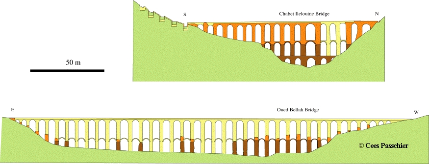
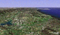
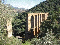
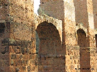
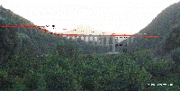
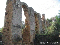
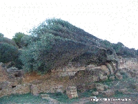
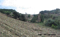
2. Chabet Ilelouine bridge
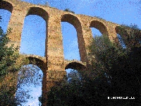
This bridge which crosses the gorge (chabet) of the Ilelouine creek is the most spectacular one in Algeria: 35 m high, 137 m long and intact except
for the collapse of two arches. It can easily be reached from the main road by a dirt track that starts at the South side of the modern blue road bridge.
Park off the track near the bridge, since there is some local traffic on the track. It is presently not possible to make good overview photos because
of the big trees which are growing up around the bridge, notably some big eucalypts on the West side.
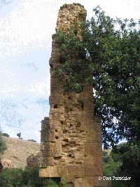
The bridge consists of three tiers; two of ashlars around a concrete core, and a third tier of concrete poured into formwork. The lowest tier is an
independent bridge, 8 m high, which acts as a rigid, stable base for the two upper tiers. The two upper tiers are in fact 25 m high pillars which are
cross-braced by small supporting arches that serve to inhibit sideward shift of the columns. The whole bridge is tapering upwards through a series of steps,
thus reducing the weight of the upper tiers. This is best visible in the upper concrete part which shows the putlog holes of the scaffolding and
impressions of the formwork. Each step of the concrete pillar was built in 4 pours, and after each of these the formwork was lifted up and
set higher on the scaffolding. The top arches have voussoirs of tiles, and are set on a leveling course of tiles in the concrete which acts as imposts.
In the intrados of the arches one can still see imprints of reeds that covered the wooden centring.
Interesting is also the transition from stone to concrete, which includes vertical cornerstones set aside the arches and supporting them, but themselves
wedged in at top and bottom by stretchers, blocks parallel to the inside wall of the pillars. This solid construction of the transition between the
two types of building material is probably one of the reasons the bridge is so well preserved.
Another interesting fact, which is difficult to verify since all traces are hidden under vegetation and soil, is that the original aqueduct passed all around
the Oued Ilelouine valley over 3 km; as a result, the difference in altitude of the aqueduct segments on both side of the gorge is too large; over 12 metres!
It is not possible to correct this with a steep slope of the bridge, because the speed of the water would have destroyed the channel and caused
overflow on the downstream side. The solution what was chosen is a dropshaft cascade, a series of four chutes and basins where the water could
drop down to the level of the bridge without causing harm.
3. Oued Bellah Bridge
This two-tier bridge, directly on the main road, was originally 288 m long and 26 m high, longer than the Pont du Gard! The bridge is now a sorry sight.
The ruins are remains of the first tier, with stumps of the pillars of the second tier rather inelegantly sticking out. Also, what remains it is slowly being
overtaken by hovels, houses and fences leaning against the pillars and hiding them. Nevertheless, the bridge is interesting. It differs from the
Oued Ilelouine bridge in that it had only one tier of stone, and a second tier of concrete.
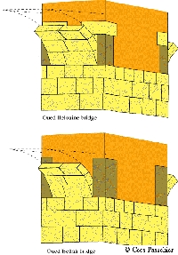
Reconstruction of the Oued Ilelouine and Oued Bellah bridges,
after Leveau and Paillet (1976). Remaining parts in orange (concrete) and brown (ashlar), restored part pale yellow
The valley in which the bridge was built has no solid rock close to the surface for foundations and the pillars of the bridge
are therefore embedded in the alluvium and subject to settling. This may be a reason why the architect choose for a solution with
only light bracing arcs instead of a lower story of solid arches, as in the Oued Ilelouine bridge.
There seems to be no good reason, however, for another major difference. The transition between ashlars and concrete is made in a less solid way
than in the Oued Ilelouine bridge: as in the latter, four corner stones are set to the side of the arches , but the blocks in the Oued Bellah bridge
are taller and are not wedged in by stretchers at the top, but simply covered with concrete. As a result, many of the blocks dropped out,
critically weakening the pillars at the level of the arches, and this is probably the main reason why the bridge collapsed.
The fact that the bridge is in a valley that funnels the strong Northerly winds which are common in this area means that any instability
can have lead to collapse by earthquake or by an exceptional storm. In any case, we can attribute the failure of this bridge to human (Roman) error.
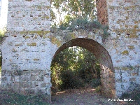
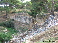
4 - Pointe Riad bridge
This is a small but interesting bridge over a narrow gully 100 m South of the main road and easily visible from the road. It is possible to park next
to the bridge. Unfortunately, the local village has decided to use the bridge as a rubbish dump. The bridge is unusually massive for such a small valley,
with stepped foundations leading up to a massive concrete core carrying the channel, remains of which are well preserved. The arch of the bridge is small,
more like a culvert than a bridge. The reason that the bridge was built in such a massive way is probably the local geology. The bridge is build on
soft shale with a strong tendency to slip. Most likely, the engineers had several problems with precursors to this bride, or other bridges and decided
to solve the problem once and for all. It worked to some extend, since the bridge still stands, but the arch is broken and also the concrete body
upstream has cracked.
5. Oued N'Sara bridge
This bridge, or what remains of it, is less easy to reach. It is possible to drive if one can find the turnoff, but it can best be reached on foot along the
tracks that follow the creek on the West side. Pillars of the bridge lie spread out in a U-shape crossing a shallow kettle where the valley widens out
to the South. Prominent is one pillar in the centre, which is well preserved and built of concrete with chains of cut stone along the edges.
The other pillars lean drunkenly in different directions, or have fallen down. Interesting is that the upstream bridgehead lies at a lower level than
the central pillar; this means that although it seems to be in its original place, it must have slipped down the slope by several metres.
The tall central pillar is probably a Roman repair of a pillar that fell and was replaced by something more solid. Since the remains of this bridge
have shifted very little between my visit in 2006 and the photographs from the 1960's (??) in the book by Leveau and Paillet, the damage must
have happened long ago. It has been suggested by Leveau and Paillet that the difficulties in this valley, affecting this bridge were the main reason
to abandon the old trajectory of the aqueduct, and to build the new one including the Oued Bellah bridge.
C.W. Passchier
Acknowledgement:
Most of the data in this section are from the excellent book by Leveau and Paillet describing the aqueduct.
I wish to thank Tahar Aifa, his brother and his student who drove me to see the aqueduct and who had to have a lot of patience while I took a long time clambering over the remains.
Cherchell - CAESAREA MAVRETANIAE
| Item
| Info
|
| Length |
45 resp. 35 km |
| Cross-section |
m x m |
| Volume |
33.800 - 48.900 m3/day |
| Slope |
0,20 resp 0,29 % |
| Period |
Augustan |
| Features |
|
| Recommended literature :
|
- Bèrard, J. 1934. Note sur les aqueducs antiques de Cherchel. Revue Africaine 75, 361: 28-29
- Leveau, Ph. 1988. Caesarea. In: Die Wasserversorgung antiker Städte. Zabern, Mainz. Band 3
- Leveau, Ph and Paillet, J.L. 1976. L'alimentation en eau de Caesarea de Mauretanie et l'aqueduc de Cherchell. Harmattan, Paris.
- Leveau, Ph and Paillet, J.L. 1977. L'aqueduc de Caesarea de Mauretanie. Archèologia 105, 28-37
|
| Recommended website :
| none
|
| How to visit :
| see main text above
|