Drover Berg (G)
Roman aqueducts
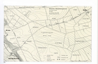
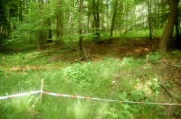
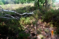
Drover Berg
THE LONGEST ROMAN AQUEDUCT TUNNEL NORTH OF THE ALPS
Considering the fact that large parts of the course of the Roman aqueduct under the Drover Berg (Germany), left over after almost 2000 years,
were destroyed by German and Allied armed forces whilst 'exercising', it is good to learn that an initiative by the well known roman aqueduct
specialist Dr. Klaus Grewe has brought to light the remains of this antique engineers feat.
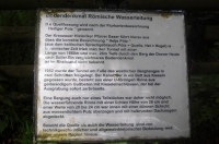
On September 13, 2009 the 'Drover Berg Archaeological Path' was officially opened and a
flyer
(in German) was published which does show some interesting photographs from the 1982 archaeological excavations.
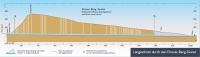
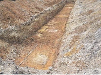
What we have here, is the longest known Roman aqueduct tunnel north of the Alps. With a length of 1.660 m (approx. 1 mile), it supplied
water from a local source known as 'Heiliger Pütz' (Heiliger = Holy and Pütz comes from the Latin term puteus = well) to a
Roman villa rustica located somewhere near the modern village of Soller-Vettweiss; however so far its final destination is not
known. Here the last part of the aqueduct is running in SE direction. The villa was located on the other side of the hill today know as
Drover Berg. This hill, with a width of 2,5 km and a height of up to 25 meters, is running north-south and had to be 'overcome' by a tunnel.
THE TUNNEL
During the design phase, a Roman surveyor (agrimensor) chose to under tunnel the mountain by means of the so called qanat method. For
detailed information please see qanat and the article on the Roman Walferdange qanat in Luxemburg. This method, contrary to the method
of starting a tunnel simultaneously at both ends, bears little risk of missing each other and consist of horizontally dug tunnel segments connecting
closely spaced vertical shafts.
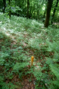
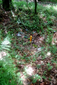
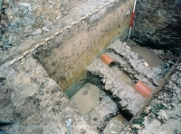
In all, over a 100 shafts were dug for the Drover Berg tunnel of which about 50 could be traced by way of searching for indentations in the upper levels
of the soil. On the slopes these shafts are between 12 to 15 meter apart and on the plateau 17 to 20 meter. Shaft widths are between 1,2 to 2,1 meters.
One very interesting aspect discovered was that the surveyor (possibly attached to a Roman Legion) came out to mark the shafts locations
but did not stay to oversee the actual construction, but he still had to make sure that the actual building crew also knew the depth of each
tunnel so as to have sufficient gradient for a free gravity flow. In what may be called a stroke of genius, he marked the shafts distances so
that the distance from one shaft to the next equalled the required depth of the initial shaft! So a rope the length of the horizontal distance
would show when the prescribed vertical depth was reached.
The largest depth to be dug was: 26 meter. The shafts also are NOT laid out in a straight line but follow the lay of the land, the hill's saddle,
so guaranteeing the shortest shafts depths. Once all shafts were dug and connected to form a tunnel with an average height of 1,80 to 2,0 meters,
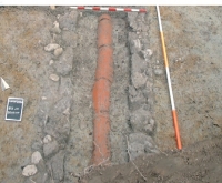
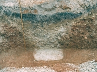
all was ready for the actual water carrying canal - in Latin called the specus - to be installed.
The canal was built in a Roman concrete known as opus caementitium (from which is derived our word cement but please note that the quality
of our 'Portland' cement was unknown to the Romans).
In order to guarantee that walls and floor were waterproof, these were covered with a hydraulic water proofing plaster 0,05 m thick, called
opus signinum. The hydraulic function was achieved by
adding grounded fired bricks , tiles or ceramics to the plaster. In practically all
roman aqueducts one can find this opus signinum; most often applied in several layers.
The channel was covered by means of so called imbrices, 4 cm strong half pipe ceramic coverings, used in Roman roofing to cover
the 'seam' between two roof tiles. As a final long term precaution, the channel itself was protected against infiltration of surface water by wrapping
it in clay. As a further measure all shafts were also back filled with the same material.
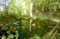
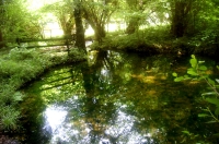
THE SOURCE
The 'Heiliger Pütz' is actually a source 'bowl' into which several independent streamlets released their water. The water volume delivered per
day is ca 480 m3 (127.000 US gallons). In order to maximise the available quantity, the Romans dammed off the source's outflow into the brook
Thum Bach nearby and then build an out flowing canal that after about a 100 meters, met the tunnel canal at the food of the slope, see
the photos in the German flyer. From there the tunnel of the aqueduct started all the way underneath the Drover Berg to the Roman villa rustica
on the other side.
The confidence of the Roman builders in the long term maintenance free functioning of such qanats was justified as a number of them still
functioned (see for instance in Walferdange, Luxembourg) after almost 2.000 years.
Driek van Opstal
BASIC DATA
Source
- GPS: N 50.43.338 - 006.31.450
- NN: 191,78 meters above sea level
Canal specification
- Width left wall : 0.20 m
- Width right wall : 0.24 m
- Floor strength : 0.25 m
- Inside width : 0.20 - 0.24 m
- Inside height : 0.26 m
Driek van Opstal
Drover Berg
| Item
| Info
|
| Length |
1660 m |
| Cross-section |
0,24 - 0,26 m x m |
| Volume |
480 m3/day |
| Fall |
% |
| Period |
Augustan ? |
| Features |
- Covered with half pipes
- about 100 shafts
|
Recommended literature
(in German):
|
- K. Grewe (1983): Der Aquedukttunnel durch den Drover Berg bei Vettweis-Söller Kreis Düren. In: Ausgrabungen im Rheinland 1981/82 pag 159/163
- K. Grewe (1984): Römische Tunnelabsteckung am Beispiel des Droverberg Tunnels. In: Allgemeine Vermessungsnachrichten 91.1984 pag 246/254
- K. Grewe (1986): Zur Geschichte des Wasserleitungstunnels. In: Sondernummer Antike Welt Volume 17.2 (1986) pag 65/76
- K. Grewe (1987): Der Droverberg bei Düren. In: Die Römer in Nord Rhein Westfalen
- K. Grewe (1998): Grewe, Klaus. Licht am Ende des Tunnels. Planung und Trassierung im antiken Tunnelbau
|
| Recommended websites :
|
|
| How to visit :
| Start in Drove, 35 km SW of Köln (Cologne, Germany), looking for the 'Heiliger Pütz'
|