Fréjus (France)
Roman aqueducts: Frejus (France)
Frejus - FORUM IULII
Forum Iulii was founded by Caesar in 49 BC, and Cicero mentioned the town in one of his letters. Augustus established here the veterans
of the VIIIth Legion in a colony. Part of the fleet taken from Marcus Antonius in the battle of Actium, where he was defeated with Cleopatra,
was established in Fréjus as a military fleet. A number of fine buildings were erected such as ramparts, an amphitheatre, a theatre and harbour
installations, but there is some evidence that not the entire area within the ramparts was settled. Gnaeus Julius Agricola,
Roman general and governor of Britain was born in Forum Iulii. Little is known of the later history of the city, although the city had
a bishop very early on. In the Middle Ages Fréjus retracted to a small village in the SW corner of the ramparts and in the 1950s
the population had not yet exceeded 6.000 people.
The aqueduct
The aqueduct of Fréjus was built in the middle of the first century after the ramparts were in place. It functioned for 450 years until the Vth century.
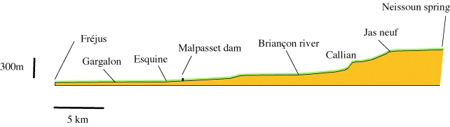
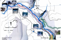
It is 42 km long, with a difference in altitude between the highest spring of Neïssoun and the castellum aquae in the city of 481 m. The aqueduct runs
mostly in a covered conduit for 36.4 km and for 1.8 km on bridges and 500 m on walls. Large parts of the aqueduct are still well preserved.
In 1874 by reusing the Roman aqueduct a concession of 26.000 m3/d (300 l/s) was given for irrigating the fields in the area of Caillan and Montauroux.
Twenty years later this system was partly rebuilt and extended to supply Frejus again with water from the Neisson sources, 1500 years after
its abandon during the barbaric invasions. The capacity became 32.500 m3/d (375 l/s). After World War I the system was again extended,
partly with new channels, to 37.000 m3/d (425 l/s) to supply not only Fréjus, St Raphael and many of the towns in the surrounding mountains
but also the military camps and hospital NW of Frejus.
Map of the aqueduct of Fréjus (aqueducts in green)
Originally, an aqueduct of 26 km long was built from spring of La Foux, at 160m altitude near Fontdurane, to the city. Until recently the capacity of this spring was 7.000 m3/day
(y 80l/sec) but the springs of La Foux dried up totally. In Roman tomes it was probably insufficient for Forum Iulii, and the aqueduct was extended by 13.5 km
to the more abundant Neïssoun spring in the Siagnole valley below Mons at 516 m ASL. Apparently, the La Foux source was then abandoned.
The Neïssoun Spring lies on the left bank of the Siagnole de Mons creek, 300m below the city of Mons. The creek upstream from the source is known as the Fil.
In Roman times, the spring must have been powerful, and the task of tapping it for the aqueduct must have been challenging. Nothing is preserved
of the installations at the source, but immediately downstream the aqueduct conduit was built of huge ashlar blocks connected with metal clamps and covered
by flat stone slabs in a cutting made in the cliffs on the left bank of the creek. A hundred metres downstream from the spring, the aqueduct crosses
over to the right bank on a bridge of large limestone blocks, of which only one bridgehead is preserved on the left bank of the creek. The conduit then
hugs the right bank of the creek for some kilometres to San Peire as a buried channel covered by flat stone slabs. There is a small bridge at Saint-Thomas
and 1.8 km from the source the aqueduct reaches a vertical limestone cliff. Here is the famous "Roche Taillée", the "cut rock". After passing this obstacle,
the conduit crosses the Ambus creeklet by a small bridge, and another small bridge at St Peire which has disappeared. The aqueduct then leaves
the Siagnole river to head south, and passes in a trench cut into limestone between San Peire and Jas Neuf. In these first few kilometres, the slope
is gentle, first 1%, steepening to about 1.2%. At Jas Neuf, the aqueduct drops down in the valley of the Camiole creek where it follows the left bank.
It steepens here first to 10%, then to 24% west of the village of Callian. The aqueduct must have contained chutes in this section, but no remains
have been found. The conduit was buried in a trench the whole distance from Jas Neuf to Fondurane over 9km.
At Fondurane it reaches the Biançon river valley. Here lies the original source of the aqueduct at La Foux. The aqueduct slope is gentle here again, about 0.7%.
The aqueduct passes to the east of the La Foux spring at Fondurane, and crosses the Biançon river at the tip of the present St-Cassien reservoir,
then turns sharply east to follow the right bank of the Biançon and crosses the Carpenée valley by a bridge. It crosses the Saoutet bridge which now drowned
in the St-Cassien reservoir. At the S tip op the St-Cassien reservoir, where the aqueduct reaches the Vaux creek which joins the Biançon from the south,
the aqueduct turns SW UPstream to the watershed with the Reyran creek. The slope of the aqueduct is gentle in this entire section, at 0.14%.
Where the Vaux valley turns east, the aqueduct passes from the area drained by the Siagne river, which enters the sea at Cannes over the watershed
to another river system, that of the Reyran, which enters the Mediterranean south of Fréjus. The aqueduct steepens in the first section along the Reyran,
but gradually flattens out in the approach to Forum Iulii.
For the next 5.3 km the aqueduct follows the left bank of the Reyran river as a buried conduit, crossing the side valleys on a series of 12 bridges
and wall sections up to the wider valley of Gargalon. This valley is crossed by a large bridge of up to 12 m high and 234 m long. The slope
of the conduit is gentle here, about 0.7%. In the next section of 4.4 km, the conduit is mostly buried, but emerges in two low aqueduct bridges, the Arcs Bérenguier
and the Arcs Bonnet.
Profile of the Roman aqueduct of Fréjus; Vertical height exaggerated. Based on data collected by V. Valenti
Fréjus
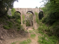
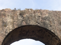
In the Parc du Chateau Aurelien the conduit leaves the ground and runs on top of a wall for a short distance, and then as an arcade of 710 metres long
towards the city wall, originally in a monumental set of 87 arches of up to 16 metres high, of which some are preserved. The slope of the conduit
is 0.16-0.12% here.
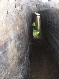
The last part the conduit runs along the top of the ramparts for 700m. At the NE corner of the walls, the conduit cuts off a corner. The castellum aquae
(the water distribution basin) was near the quarter "Moulin á Vent" in the Rue du Bel-air, at 35m ASL, but nothing is preserved of the castellum which has been overbuilt by the present private house at the end of the street. Remarkable here are the remains of an open conduit after the water left the castellum.
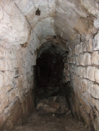
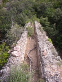
The conduit of the aqueduct is mostly a typical concrete structure consisting of a 0.40 m thick concrete base, sidewalls of 0.45 m thick,
and a vault constructed on formwork. The complete structure was about 2.4 m high, buried or on bridges. The aqueduct bridges have variable heights
between 2 and 13 m, but a constant diametre of the arches of 5,4 m (18 Roman feet).
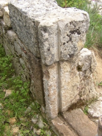
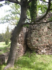
The aqueduct bridges and walls have an attractive architecture. All visible parts of the aqueduct are faced in regular courses of "petit appareil"
of coloured stone, in many cases alternating the colours, mostly red and green. There are no imposts, but the arches have a double set of voussoirs
with an internal ring of extremely thin and elongate blocks, and extrados ornamented with a row of "petit appareil", mostly elongate stones that lie
parallel to the arch. The double voissoir was probably conceived for ornamental reasons.
Problems of wind and geology
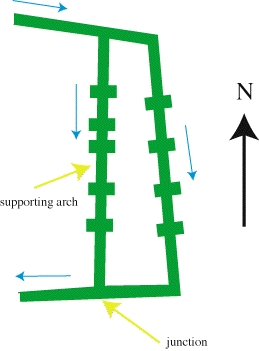
A characteristic feature of the Fréjus aqueduct is the common presence of sloping buttresses on the pillars, giving the pillars a cross-shaped section.
Many of the pillars are more than 10m high without supporting cross-bracing arches as in Merida or Cherchell, or a stepped widening towards foundations
as in Cherchell and Tarragona. Buttressing is necessary for such tall pillars if they are put under unusually stresses. One local problem is the Mistral blowing
from the N or NW which can be a danger to structures like the arcade in the approaches to the city. However, since many bridges with buttressed pillars
are set in narrow valleys where the wind would not have been a problem, a more likely, or at least equally important reason is the problem of the
foundation of the pillars of the aqueduct bridges.
Four aqueduct bridges are doubled, set face-to-face, one of which (the Senequier) even has two separate aqueduct bridges over a single valley.
The reason for this is not entirely clear, but it is certain that at least on some bridges (e.g. Senequier) both channels functioned at the same time.
This can be seen from the sinter deposits in the conduit. Since the local geology is complex with strongly variable rock types and small blocks
separated by faults, land sliding and settling of aqueduct bridges must have been a problem. In some cases, bedrock may have been to deep down to reach
and the pillar foundations had to be set in the alluvium of valley, in a climate with torrential winter rains. In all cases, the double bridges may have been
a means of securing the water supply to the city if one of the bridges produced a problem. As an example, the Senequier bridge was apparently doubled
after part of the first bridge collapsed. The new, western Senequier bridge (see below) has an unequal spacing between pillars, with one unusually
narrow and one wide arch, the latter with pillars supported by a cross-bracing arch in the lower parts of the bridge. An explanation could be
that the place where the pillar had to come in the case of regular spacing was unsuitable, and had to be shifted to the north. The entire Senequier
structure, with a double bridge, widening buttresses, unequal pillar spacing and a bracing arch, points towards severe problems with the local geology.
Malpasset disaster
A sad chapter in the history of Fréjus and the aqueduct started with the construction of the Malpasset dam in the Reyran valley in 1950.
The local geology was insufficiently investigated, and a major fault in the rocks at the dam site was not recognized. In 1959, when excessive rains filled
the reservoir behind the dam to maximum level for the first time, the caretaker noticed the opening of major cracks in the dam and gave out
a warning, but the authorities refused to release water from the dam because of the possibility that it could damage the piers of the A8 motorway bridge
which was then under construction downstream. The eastern support of the dam then gave way, the dam collapsed and a 50m high wall of water roared
down the lower Reyran valley to Fréjus. The motorway bridge was destroyed together with a village just downstream and the destruction in the valley
and in Fréjus was enormous, with 420 people killed. Several sections of the aqueduct were washed away as well.
Sadly, the fact that the Roman engineers buttressed and cross-braced the pillars of the aqueduct, and doubled many of the bridges could have been
a warning that the local geology is treacherous for bigger structures.
Visible remains
In order to find the visible remains, it is useful to have the 1:25.000 topographic maps 3543 ET "Haute Siagne" and 3544 ET "Fréjus-St-Raphael".
The photo's of many visible remains are presented below
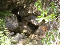
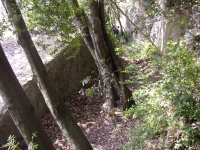
Siagnole source area
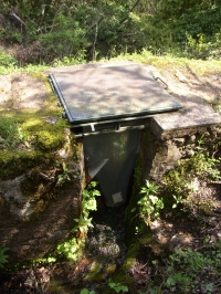
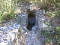
Of the three sources present on site, the Roman aqueduct used the Neïssoun spring on the left bank of the Fil creek, a few metres from the river bank.
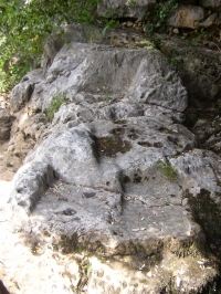
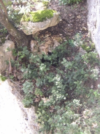
This source produces presently 200-300 l/second. The source itself is now enclosed in a small building. About 40 m downstream, a cutting
in the vertical rock face on the left side of the valley indicates the track of the aqueduct. Originally, a series of horizontal and vertical rock slabs,
bound together with iron clamps in lead, were used to build a conduit of 2 m high and 1.65 m wide, with a specus of 0.67 x1.34 m.
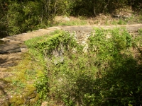
Presently, only the blocks rearranged in a rectangle and is used now as a pick-nick place; the excavations in the rock wall are visible. A hundred meters
downstream the aqueduct crossed the Siagnole river by a bridge of large limestone blocks. Only one bridgehead is preserved on the left bank. The place
of the abutment is clearly visible.
From this point on, the Roman aqueduct was reused in the 19th century. Halfway one crosses the Pont de St-Thomas, a modern version of the ancient
Roman bridge including now two regulation facilities.
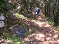
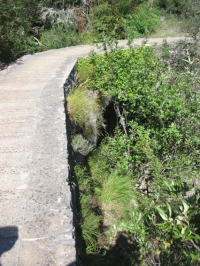
It is possible to follow the aqueduct on foot over the reused antique cover stones following the Grand Randonée 49. Notice that the Grand Randonée runs
towards the Siagnole source by two tracks, the upper one following the reused Roman aqueduct, while the lower one follows an aqueduct from the 'modern'
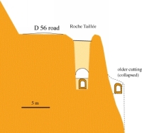
Jourdan sources lower down the slope. Crossing the D56, the track runs a few metres below the road surface and reaches the Roche Taillée
Roche Taillée
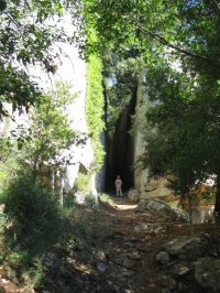
The Roche Taillée lies east of the D56 road below the level of the road. The only indication is a small sign "aqueduc romain". It is possible to park
along the side of the road and to walk down onto a track that passes through the rock cut. A small bridge crosses the cutting to a platform
on the edge of the cliff that gives a good view of the scenery.
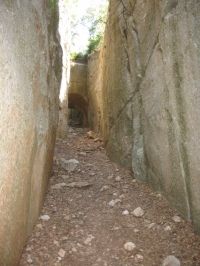
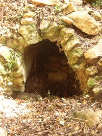
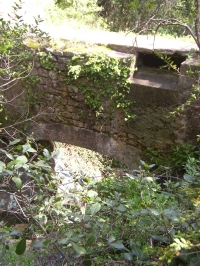
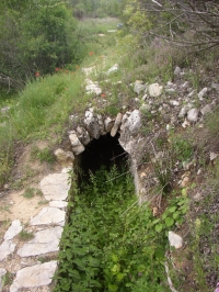
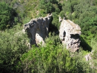
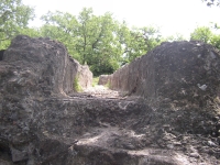
The Roche Taillée is a cutting in massive Jurassic limestone 12 m deep and 30 m long, with an arch of rock which was left standing in the centre.
Here, the engineers tried to overcome a vertical limestone cliff of 150 m high by cutting a shallow trench close to the cliff edge along the side of the outcrop.
This did not succeed, and the whole work fell 150 m down into the valley. A new, more expensive attempt was then made cutting the outcrop
a few metres inwards to a depth of 12 m, leaving a small arch to support the walls of the rock cut for stability. The reused aqueduct (canal Jourdan) still passes
along the bottom of the cutting below the old track.
A small bridge of one arch on the Ambus creeklet - quite similar to the Pont de St-Thomas - probably rebuilt from old masonry blocks of the original bridge,
is visible at the southern end where the aqueduct is covered by the reused original slabs.
Jas Neuf cutting
From Roche Taillée, a footpath follows the Roman aqueduct towards a small chapel of St Peire. Beyond St Peire towards le Jas Neuf,
near a house on the D 37 the aqueduct passed through a 15 metres deep cutting in the limestone.
La Foux spring and Fondurane
Between Jas Neuf and Callian there are no visible remains. The next interesting site is at Fondurane, at the western tip of the St-Cassien Reservoir
south of Montauroux. Here, the original source of the aqueduct which provided Fréjus with water and a section of the Neisson aqueduct can be seen.
The La Foux spring, discovered in 1982, was the original source for the aqueduct of Forum Iulii, as has been shown from investigation
of the sinter deposits of this spring in 1990. Until recently it produced 60 l/s and lies at an altitude of 160 m ASL, 26 km from Fréjus.
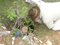
About 2.5 m from the spring, a manhole covered with a concrete slab can be seen in the aqueduct which is here in a trench 2.2 m wide.
The junction with the Siagnole aqueduct lies just downstream from the sharp corner in the conduit, 250 m from the La Foux spring. A 400 m long section
of the Siagnole aqueduct is exposed. The northern and southern parts still retain the original vault, but the central section has collapsed.
The specus is 0.60 - 0.68 m wide and 1.4 to 1.5 m high. The walls of the conduit are faced in "petit appareil" and the vault in concrete set on formwork.
The vault is a rough arch built from only five planks, impressions of which are clear. The formwork apparently rested on the floor of the conduit,
not on the walls since the vault is in line with the walls. Where the Neisson aqueduct cut the La Foux branch, the La Foux branch was walled off,
traces of which are visible. A short section of the aqueduct was excavated as a tunnel.
About the relation between both sources, La Foux and Neisson, Vito Valenti takes an other point of view than Gébera: the former distinguishes four phases:
1) the La Foux source supplied Frejus, 2) The Neisson aqueduct was built and took over the original channel just after the start of the La Foux channel,
3) the La Foux source fed by means of a newly built conduit a mill nearby, 4) the La Foux aqueduct got its own channel back; the Neisson joined
the La Foux channel 250 after the start of La Foux.
Carpenée bridge
Remains of the bridgeheads of the Carpenée bridge are visible south of the tip of the St-Cassien reservoir. The remains of the bridge over the Biançon river
are not visible.
Beyond Carpenée, the aqueduct dips below the waters of the St-Cassien Reservoir since 1966. Originally, there was a bridge at Saoutet that is now
submerged. There were also aqueduct bridges crossing the Fontfreye valley and at la Fustière.
Jaumin bridge
The next bridge that is visible is that of Jaumin. This bridge was doubled at some stage, but the western (older) one has collapsed, as can be seen
from the absence of facing to the rubble masonry core of the bridge on that side. The double conduit can be seen to join downstream.
It was covered for several years by the reservoir of the Malpasset dam, together with 4.5 km of the conduit until the dam broke in December 1959.
One section of the conduit on a wall upstream from the dam, "l'ouvrage de la Madeleine", was washed away during the catastrophe.
Conduit below Malpasset Dam site
Traces of the conduit survive on the left bank of the Reyran 30 m above the river.
Lower Reyran structures
In the next section, east of the road to the Malpasset dam and before the D37 crosses the A8 highway, there are a number of bridges and other structures
in the side valleys to the east. These are, from north to south:
- Esquine bridge (also known as the Bonhomme bridge)
This bridge across the Apié d'Amic creek still has five of the originally eight arches on the downstream side with a maximum height of 10 m. The bridge
was partly doubled at some stage, with a second conduit and arches on the north side. This bridge was saved from being washed away by
the Malpasset catastrophe since it set back in a side-valley to the north where the main valley curves south, and the main force of the water
was directed toward the SE. Large blocks of concrete of the broken dam lie just downstream from the bridge. Several structures downstream were destroyed,
a.o. pillars of the Boson bridge.
- traces of the conduit cut in the rock with a talus slope, with major sinter deposits of up to 22 cm thick with a manhole.
- along an asphalt side road towards the Boutelliere-reservoir one of the four double bridges, the Grisolle 2. Only a part of the downstream bridgehead
survived. The older west channel has been partly blocked.
- Collet du Reyran bridge / Arche Magail, with one small arch of 1.53 m in a 25 m long supporting wall.
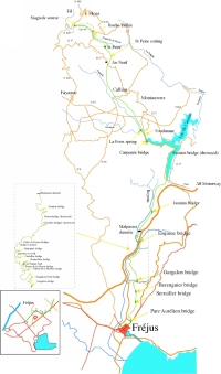
Map of the Senequier bridges
 |
- Senequier bridge (also known as the Escoffier bridge). This is a double structure with two bridges a few metres apart and diverging. The eastern bridge
is the older one. Each bridge has 6 arches with sloping buttresses with a maximum elevation of 12 m. The westernmost bridge is unusual in that
the distance between pillars is not equal. One of the pillars is offset to relatively to the north, supporting one narrow and one wide arch.
The wide arch has a supporting cross-bracing arch lower down.
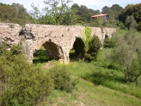
- the Bouteilliere bridge in the Cayette valley is hard to find but it is in splendid condition. The bridge has three arches up to 12m high, massive bridgeheads and
sloping buttresses on the pillars. A bas-relief of a legionary was found on the central pillar which points to the involvement of the legionnairs of the VIII army in constructing the Frejus-aqueduct - as a counterforce to the 'Greek' city of Massilia?
- the Castellas bridge with one single arch, is rather damaged.
- Biaise bridge, with one skewed (biaise) arch, where the axis of the arch is not normal to the long axis of the bridge.
- Pont de la Moutte bridge, with six arches up to twelve m high. The four tallest pillars have sloping buttresses.
- Gargalon north bridge, with a singe arch.
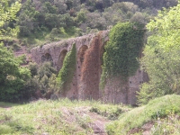
Gargalon bridge
The valley of the Garagalon creek is wide and was crossed by a bridge of 234 m long of originally 14 arches of up to 12 m high. A single arch straddles
the road, and several others are visible in the fields south of the road, heavily overgrown. Four of the taller pillars had sloping buttresses; one of them
supports the arch across the road. This section is badly in need or restoration, and one arch collapsed as recent as 1967. In the 19th Century,
the bridge was still intact. The specus of the aqueduct and a manhole in the covered part are visible on the north side of the valley.
Bérenguier bridge
The Bérenguier bridge lies in a shallow valley between the Sainte Brigitte and the Vert Estérel estates, east of the D37, between the end of the
Avenue Horace and Allée des Arcades. It is 60 m long, with five arches of up to 5 m high.
La Combe de Rome or Bonnet bridge
This bridge lies west of the gated community of the Pinède Romane. It was a bridge of five arches up to six m high of which two were demolished during
development and construction of the quarter.
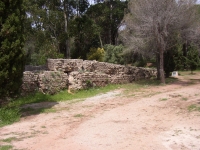
Wall of St Brigitte
Near the Avenue des Portes de Soleil. This is low wall, 37 m long and 1-1.5 m high which carried the aqueduct. Parts of the specus are preserved.
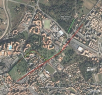
The final arcade of the aqueduct up to the walls of Frejus, and the section along the ramparts. Visible sections in solid green. Numbers refer to figures in text.
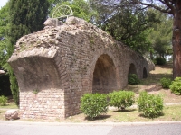
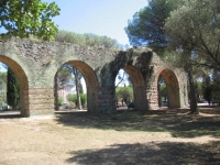
Parc de la Villa Aurélienne (#1 on map)
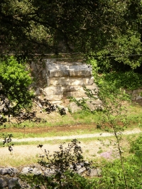
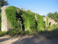
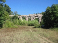
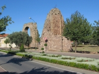
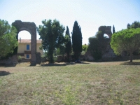
Now we are entering the Fréjus area. Impressive remains of the northern section of the arcade that carried the aqueduct in its approaches to the city
of Forum Iulii lie in this town park. In the north, the aqueduct emerges from the ground and runs on a short wall, which is followed by several sections
of preserved arches. These low arches have no buttresses. The facing is in attractive "petit appareil" of green stone, in some pillars alternating
with tile courses (opus vittatum). The conduit on top of the arches has a vault.
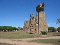
Avenue du XVe Corps / Pont-aqueduc de Sainte-Croix
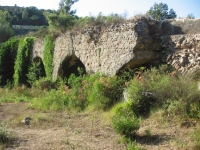
The final section of the aqueduct up to the city wall was an arcade of 710 m long and 87 arches. Several pillars and remaining arches are visible
on both sides of the Avenue du Quinzième Corps south of the Parc de la Villa Aurélienne and the roundabout (Rond Point de Triberg).
The Avenue du Quinzième Corps roughly follows the trend of the original Via Aurelia which left the NE gate of the city ("Porte de Rome") here towards
Antipolis and Rome. Some of the remaining pillars are 16 metres high. The pillars are concrete with a facing of nicely coloured petit appareil,
with prominent sloping buttresses. This section of the aqueduct is in a town park on the edge of Fréjus. The arcade remains are also known
as the "Arcs de Sainte-Croix". The arcade changes direction halfway to the walls because it reached the Via Aurelia at that point, which in the past
ran parallel to the last section of the arcade.
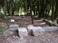
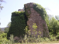
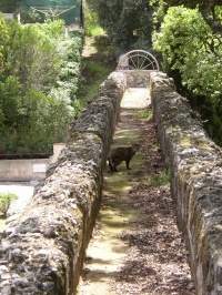
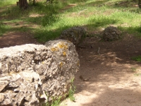
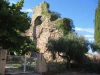
Ramparts
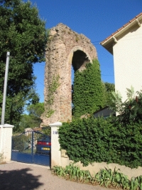
The last part the conduit runs along the top of the ramparts for 700 m. It started at the northern town gate where the conduit crossed the top
of the north tower with an arch (#3 on the map). The towers of the gate have collapsed, but the aqueduct was apparently better built
and has survived.
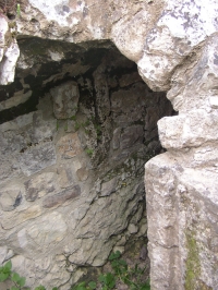
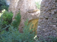
Two arches of the aqueduct are visible where they crossed the inside of towers on the NE side of the ramparts.
At the NW corner of the walls, the conduit cuts off a corner. The conduit can be followed over the plateau behind the walls in this corner. The wall
reached its highest point here and it was probably easier to make the cutoff then to demolish the wall.
The conduit then followed the walls along the NW side, and two arches are visible where it crossed the interior of two towers which have disappeared.
One wonders about first century town planning where costly ramparts and towers are built, only to wreck them as a means of defense by
rebuilding wall and towers to carry the aqueduct conduit, while a series of arches inside the ramparts would also have served. For the already staggering
costs of the aqueduct one would think that it would not have made much difference. This section of the aqueduct can be seen from the park near the cemetery
that lies outside the ramparts, and from the Rue des Aqueducs on the inside of the ramparts.
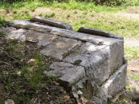
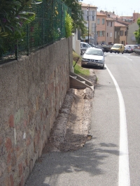
Rue du Bel-air
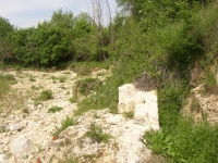
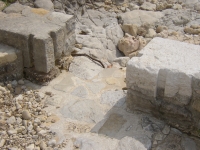
The aqueduct must have ended in a castellum aquae at the platform of Moulin á Vent, at the end of the Rue du Bel-air. Nothing remains now. In the
Rue du Bel-air there is a section of an open channel that belongs to the internal water distribution system inside the city of Frejus.
Cees Passchier
with some additions bij Wilke Schram
Fréjus - FORM IULII
| Item
| Info
|
| Length |
39,4 km |
| Cross-section |
0,60 m x 1,12 m |
| Volume |
52.500 m3/day |
| Fall |
1,2 % |
| Period |
Middle of the 1rst c AD |
| Features |
|
| Recommended literature :
|
- Vito Valenti: AQVA FOROIVLIENSIS. On the web
- C. Gébara and J.M. Michel (ed): L'aqueduc romain de Fréjus (RAN suppl 33 (2002))
|
| Recommended website :
| none
|
| How to visit :
| see above
|