| For the photo's, see below |
| Home / the complete website |
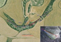
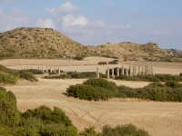
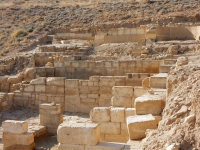
The ancient city of Los Banales (Roman Tarraca ?) grew up beside the important Roman road between Caesaraugusta (present Zaragoza) and Pompaelo (Pamplona) and had its heydays between the first century BCE and the third century CE. Important remains are left and excavations are still ongoing. The major findings are the forum, a temple, statue bases, residential buildings, an arts and crafts quarter, necropolis, the baths and an aqueduct.
Dating

|
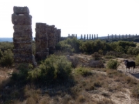
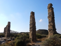
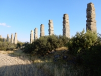
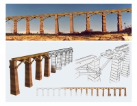
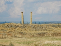
| A stretch of the aqueduct of Los Banales was built on high, isolated supports and not on a system of arcuatio or as a siphon. On top a wooden structure was built with a wooden channel or with ceramic / lead pipes. |
Traditionally the construction of the Los Banales aqueduct has been related to that of the baths, proposed in the first century CE, perhaps linked to a possible Flavian monumentalization of the civitas. More recently, however, the finding of certain marks of stonecutters in the ashlars of the pillars supporting the air channel, has led to the proposal to date the aqueduct around 9 BCE, built by Legio IV Macedonica, and also linked to the construction of the dam of Muel (30 km upstream of Zaragoza).
More complex is to determine the abandonment of the city, but it seems that in general Roman Los Banales was abandoned in the third century CE.
Introduction
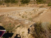
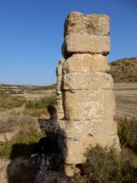
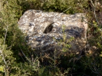
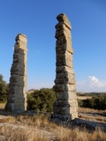
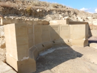
The aqueduct of Los Banales seems to have had its caput aquae at the Cubalmena dam, located at a height of approximately 538 masl (Andreu Pintado 2011). According to calculated estimates, it appears that the average gradient of the channel until its arrival in the city would be about 0,9 m / km, although this may be reduced to 0,8 m / km (0,08 - 0,09 %) in the air section of the channel supported by pillars (Viartola Laborda 2013 note 7).Exactly this is the most interesting section of the aqueduct due to its unique technical characteristics. Unlike what happened in the rest of the aqueducts in Spain, this stretch of the aqueduct of Los Banales was built on high, isolated supports and not on a system of arcuatio. Specifically, the preserved remains correspond to a total of 32 pillars, that consists of a variable number of blocks of sandstone also with variable dimensions but decreasing in most cases according to their rising positions in the pillars (with the sole exception of the ashlar coronation stones). The ashlar bases rest directly on the stone bottom of the land; sometimes recesses up to 0,30 m deep were made to create a suitable surface. The coronations have a recess serving a wooden lintel on which a wooden channel rested.
The study of the pillars also allowed us to identify, in the center of the recess of the coronation, a hole about 0,90 m from the top of the pillar that served the wooden supporting structure that propped the channel.
Visible remains
1. Traditionally it has been argued that the water collection should be near the Arba river in Luesia near Malpica, today approximately 12 km northeast of the site. However the most recent studies locate the water collection point near a possible Roman dam on the site of Cubalmena in the municipality of Biota. A special study of this dam (Andreu Pintado 2011) have shown that it is formed by a curved structure with an approximate length of 53 m and a maximum height of 2,5 m. Two types of overlapping ashlar stones have been identified and it is perhaps built in two construction phases.
RemarksGiven the quality of the ashlars and the quality of the construction (irregular, far from level) it is most unlikely that this dam is of Roman origin.Apart from this argument, Romans did dislike water from stagnant origin; they had a preference for water from springs. WDS |
2. Nor the water exit point of the dam nor the channel between the dam and the air section of the aqueduct have been identified (yet).
3. Between Puy Foradado and the first preserved remains of the air section is a distance of about 43 m, which was bridged by a continuous wall and / or several pillars of increasing height. The best known area of the air section is a stretch of 375 m formed by 32 conserved pillars (the estimated total number should be about 72 pillars) of variable height (from 3,75 and 8 m), each with a recess in the upper ashlar about 0,40 m wide and 0,07 m deep, which has been linked to the existence of the wooden supports of the air section.
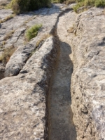
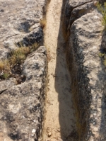
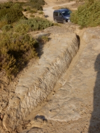
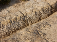
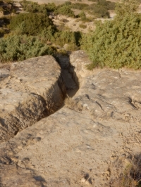
4. After the bridge, the route continues through a channel cut into the rock. This channel has a depth of up to 0,45 m and is 0,40 m wide; it seems to maintain an altitude of around 535 m asl up to the vicinity of the city of Los Banales.
5. Almost nothing is known about the main customers of the supplied water; it seems reasonable to suppose that the baths will have been one of the major water users.
|
The air section in short - Distance to be bridged: approximate 375 m - Number of pillars: 8 + 32 + 20 + 12 = 72 of which only 32 are still standing, the other numbers are hypothetical: - 8 before the first standing pillar - 20 missing pillars in between the standing ones - 12 after the last standing pillar - Height of the (standing) pillars: between 3,5 and 7 m - Pillar composition: a variable number of sandstone blocks (typical number: 12 - 15) - Typical cross-section (6 m in height): 1,40 x 0,90 m - Top blocks (the coronations) have horizontal grooves of 0,40 x 0.07 m - Each pillar had one horizontal square hole 0,90 m below the top - Distance between the pillars: 4,9 m - Gradient on the 250 m of standing pillars: 0,08% - The wooden construction on top of the pillars were used to support a wooden gravity channel or ceramic or lead pipe to transport the aqueduct water to the city of Los Banales. Remarks - For a piped aqueduct there was no need to make the support almost 100% level - Ceramic pipes would have left fragments behind in the surroundings - Was this construction on the long run cost effective compared to a traditional arcade or a siphon? WDS |
Wilke D. Schram
Text mainly based on Sanchez Lopez 2016 pag 100-104, with alterations and supplements
Los Banales
| Item | Info | |
|---|---|---|
| Length | Unknown | |
| Cross-section | 0,45 m x 0,40 m | |
| Volume | Unknown | |
| Gradient | 0,08 - 0,09 % | |
| Period | Augustan | |
| Features | Partly wooden support and 'channel' |
| Recommended literature : |
|
| Recommended websites : |
|
| How to visit : |
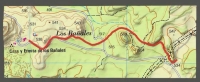
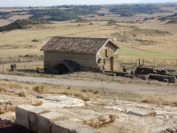
About 1,5 km NE of Sadaba; from Layana the route is signposted. Near the city hill one can also find the Ermita de Los Banales. |
| HOME | More literature on more aqueducts | Last modified: November, 2016 - (webmaster) |