NIMES 1 (France)

Roman aqueducts: Nimes (France) Nimes - COLONIA AVGVSTA NEMAVSENSIS
For the photo's, see below
Home / the complete website

Part 1: Introduction


This section is one of a series of 4:
  • Part 1: Introduction
  • Part 2: From Uzès to the Pont du Gard
  • Part 3: The Pont du Gard
  • Part 4: From the Pont du Gard to Nîmes
Each part has its own maps and photo's (see below)
Technical data are available in part 1, 3 (Pont du Gard) and 4
The literature list is present in part 4
For the photo's , see below.
Nemausus was the capital of the Volcae Arecomici before the Roman conquest. In 118 BC, the area came under Roman influence and the Via Domitia was built. In 42 BC the city received the status of a colony. The city prospered during the Principitate and the early Empire. A building program in the first century produced a six kilometre long city wall, temples, and an amphitheatre. A large spring was present inside the city walls, ornamented with an Augustaeum and Nymphaeum, but this was insufficient to serve the population and the baths. In the second half of the first century, therefore the Eure aqueduct was built. The city gradually declined in importance after the middle of the third century, and was occupied by the Visigoths in the fourth century. Most of the monumental buildings were finally destroyed with the Arab conquest and the disastrous reconquest by Charles Martel in 720.

The aqueduct


Map of the aqueduct of the Nîmes (aqueduct in green)

The Nîmes aqueduct is THE Roman aqueduct "par excellence", one of the most famous, most spectacular and best researched aqueducts of the Roman empire. Its main bridge, the Pont du Gard, is what most people have in mind when the word aqueduct is mentioned, and justly so.

The aqueduct is special for several reasons. The only suitable source that the engineers could find for the water supply of Nîmes was at Uzés, 25 km to the north at 72 m altitude. The problem was that the source was at only 11.8 m above the site of the future castellum divisorium (the water distribution basin) at Nîmes at 60 m altitude. It was therefore necessary to make the aqueduct as short as possible. A direct straight connection was not possible since the high hills of the garrigue de Nîmes, 200 m high, blocked the way. A 10 km long tunnel would have been necessary to overcome these hills. The only workable solution was a trajectory around these hills to the east, lengthening the aqueduct to 50 km. Here, there were two other major difficulties; first of all the Gardon river, which runs in a deep gorge, would have to be bridged. Upstream this could be done with a low bridge, but this would lengthen the trajectory. A choice was therefore made to bridge the gorge along the most direct route, and where the gorge was relatively narrow. As a consequence the bridge, the future Pont du Gard, had to be higher than anything previously built, nearly 50 metres high and 300m long. A siphon, known from other aqueducts, could not be used here since it needs a sizeable difference in altitude between abutments to create sufficient water flow through the pipes, and this was not possible here.

A second problem was a lake on the trajectory which was at 67 metres, 3 metres ABOVE the projected level of the aqueduct. To circumvent this lake, another 20 km had to be added to the trajectory and this was out of the question; this lake therefore had to be emptied and drained before the aqueduct could be built. Finally, to make the trajectory as short as possible, a large number of minor bridges had to be built and several tunnels, up to 400 m long had to be dug. The result is an aqueduct of 50 km long with a mean gradient of 34-25 cm/km (about 0,03%), with a maximum of 45 cm/km near the source and near Nîmes, and only 8 cm/km in the long central section! To build an aqueduct in rough hilly, forested terrain without GPS or modern measuring equipment with such a low gradient is one of the greatest feats of Roman engineering recorded to date.

The volume of literature of the aqueduct and the Pont du Gard is vast, and we can only give a summary here of what we think are the most interesting aspects.


Detailed map of the trajectory of the aqueduct near the Pont du Gard.
Numbers are UTM coordinates, WGS84 datum (aqueduct in green)


The aqueduct of Nemausus starts at the Eure springs at Uzès. After passing a regulatory basin, it runs first south, then SE in a trench along the foot of the plateau of St-Sifflet. It crosses the steep gully of Bornègre and continues towards Vers, where it crosses two depressions on low bridges. From Vers, the aqueduct turns south where it runs almost continuously suspended over a series of three arcades and a two tier bridge in a broad loop towards the Gardon. It crosses the Gardon on the Pont du Gard, and the rough country of the Forest of Rémoulins along the slopes and over a series of small bridges to a regulatory basin at Rémoulins, the Lafoux reservoir, destroyed at the beginning of the 18th century. It then makes a loop around the depression of St Bonnet, crosses a low pass south of the village and continues SW towards Nemausus, through the two Sernhac quarry tunnels and a 400m long tunnel below the village of Sernhac. It then crosses below the drained lake of Clausonne and runs along the head of the Vistre valley, and along the slope of the hills towards the city, increasingly tortuous when approaching Nemausus. It passed below the town walls by the 400m long tunnel of Croix-de-Fer through a hill to the castellum divisorium in Nîmes.

Early reconstruction

In the previous section we have presented the Nîmes aqueduct as a masterpiece of Roman engineering, which it is, but this does not mean that it did not have some problems right from the start. In the section with the lowest gradient, between Vers and Rémoulins, the conduit filled up much higher than expected, to the top of the conduit, and was probably overflowing in many places. This problem was solved in that the walls of the conduit were raised. This is very obvious in the Pont du Gard itself and in some of the bridges downstream. On the Pont du Gard, the cover stones were removed, a layer of ashlars added, the opus signinum layer was extended upwards to cover the raised section, after which the cover slabs were replaced (see drawings). Except for the Pont du Gard, the conduit was vaulted and the vault had to be removed to raise the walls, after which new vaults had to be built. Because there was permanently more water in the aqueduct than foreseen, the weight of this water on the bridges and arcades could be a problem. It could lead to collapsing arcs or push the conduit walls outwards in those sections where it was covered with a vault, which was already exerting an outward push. Therefore, in some sections upstream the arches were filled up with walls (Lône , Pont Roupt and Valive arcades) while downstream the bridges were strengthened by lateral walls to keep the conduit walls from pushing outwards.

The Nîmes aqueduct has a large number of different structures along its course, but there are some general characteristics. The aqueduct is mostly built in an excavation in rock or soil and has a concrete base, on which rubble masonry walls were built, 1.2 metres high and 1.2 metres apart (4 Roman feet). a fine concrete sole was laid in the conduit, and the walls were plastered with red opus signinum, including a beading along the edges of the channel. Strange enough, and typical for the Nîmes aqueduct, no opus signinum was laid on the sole of the channel. The conduit was then vaulted in rubble masonry so that the total height of the channel was 1.8 metres. The extrados was sealed with a layer of mortar to make it waterproof and to prevent infiltration of groundwater and the whole structure was then buried, and remained exposed on the bridges. All bridges and arcades are built in limestone, mostly in rubble masonry faced with neat courses of "petit appareil" with finely worked voussoirs. Pillars were set on ashlar bases, mostly in two courses. Only the big bridges were entire built in ashlar masonry.

A segmented aqueduct?

The Pont du Gard seen from SE
Many modern aqueducts do not operate as a free, open river but contain a number of thresholds behind which the water level is nearly horizontal, subdividing the aqueduct into segments. The advantage is that the base of the aqueduct does not need to have a perfectly constant gradient, and that speed of flow is regular throughout a segment. It has the added advantage that one segment of the aqueduct can be emptied and cleaned or repaired while the water distribution continues. If the thresholds are movable sluice gates, these can be gradual lowered downstream of the emptied section, so that the downstream segments keep emptying and providing water to customers; meanwhile, the upstream sections from the emptied segment fill up; once the repair is done (and it should be done rapidly, obviously), the sluice gates are opened and the central segment is filled again, and normal operation resumes.
Recently Glard and Bossy (2000) suggested that the Pont du Gard may already have operated according to this modern principle, and that some sections of it could be emptied and repaired while the delivery of water to Nîmes continued. It took 28-32 hours for the water from the Eure springs to reach Nîmes, and the conduit would contain 35-38.000 m3 of water, so a quick repair would have been possible. This theory could also explain the gentle slope of the central segment, and the raising of the conduit walls there; maybe, the water level rose higher than predicted in segments here.

Sinter deposits

Sinter, layered crystalline calcium carbonate, was deposited in the central portion of the aqueduct with a layer of up to 0.50 m thick. The layer tapers upwards because the water level gradually increased in the course of time. Calcium carbonate can dissolve in water that contains carbon dioxide, but precipitates due to changes in water pressure, temperature, water speed and a number of other factors. In the case of the Nîmes aqueduct, the water came from deep caves below the St-Sifflet plateau, and decompression was the main culprit of sinter deposition. Interestingly, the fist part of the conduit at Uzès is clean and free of sinter. This is because the deposition reaction starts after about 1 hour 40 minutes, and at that time the water had traveled 7-10 km and reached Bonnègre. The whole section downstream from there was affected, with maximum deposits just below the Pont du Gard. In Nîmes, deposition of sinter was much less again since most had already been removed.

Further history

Most of what we know about the Nîmes aqueduct has been learned from analysis of the sinter deposits. The aqueduct was built in the second half of the first century, and operated without problems for about 150 years, judging from the sinter deposits (100-250 AD). The sinter deposits of this fist period are massive and clear, indicating the flow of clear, unpolluted water. After this date, the sinter becomes brown and tainted, probably because the water was polluted with soil and groundwater that fell in through the broken vaults. The aqueduct kept functioning, and an attempt was made to repair it in the fourth or fifth century. At that time, the water may no longer have reached Nîmes, and much of it was diverted for irrigation in the upstream part, especially between Vers and the Pont du Gard where the arcades could easily be tapped. In 720 Charles Martel "liberated" and destroyed Nîmes, and the aqueduct, if functioning, was no longer needed.


Cees Passchier and Wilke Schram

==> For a description of the visible remains, see next entry <==


Nîmes - COLONIA AVGVSTA NEMAVSENSIS

Item Info
Length km
Cross-section m x m
Volume 35-38.000 m3/day
Fall 0,032 %
Period 2nd half 1C
Features
  • regulation basins
  • highest Roman aqueduct bridge
  • Castellum Divisorium


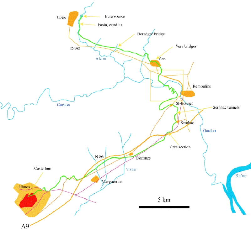
Recommended literature :
  • Hauck, G. (1988): The aqueduct of Nemausus. McFarland.
  • Fiches, J-L, Paillet, J-L. (1988): Nîmes. in: Die Wasserversorgung antiker Städte 3. 207-214. von Zabern.
  • Granier, J. (1990): The Pont du Gard. Monaco.
  • Fabre, G, Fiches, J-L, Leveau, Ph, Paillet, J-L. (1992): The Pont du Gard. Water and the Roman town. Presses du CNRS
  • O'Connor, C. (1993): Roman bridges. Cambridge University Press
  • Larnac, C, Garrigue, F. (1999): L'aqueduc du Pont du Gard. Les presses du Languedoc
  • Darde, D. (2005): Nîmes antique. Monum.
  • C.K. Rasmussen (2017): A comparative analysis of Roman water systems in Pompeii and Nimes (Master thesis, on the web)
Recommended website : Le Pont du Gard (in French)
How to visit : see above
HOME More literature on more aqueducts Last modified: March, 2007 - Webmaster
(wilke@romanaquaducts.info)


The amphitheatre

The Pont du Gard

Map of the Nimes aqueduct

Repair measures

Heightening of conduit

An extra layer of ashlars

Support walls

Typical structure
of the conduit

Sinter layers

Massive sinter deposit