Nîmes 2

Roman aqueducts: Nimes (France) Nimes - COLONIA AVGVSTA NEMAVSENSIS
For the photo's, see below
Home / the complete website

Part 2: From Uzès to the Pont du Gard


This section is one of a series of 4:
  • Part 1: Introduction
  • Part 2: From Uzès to the Pont du Gard
  • Part 3: The Pont du Gard
  • Part 4: From the Pont du Gard to Nîmes
Each part has its own maps and photo's (see below)
Technical data are available in part 1, 3 (Pont du Gard) and 4
The literature list is present in part 4
The Nîmes aqueduct is rich in visible remains, and we only mention the most important and most accessible ones here.

Sources of Eure

The source of the aqueduct was at a number of abundant springs on the left bank of the Alzon river below the town of Uzès. The Alzon is a slow, small muddy river that runs in a narrow valley with steep banks, with the town of Uzès on top of the right bank, 60 metres above the river. The spring can be reached by crossing the bridge over the Alzon from the campsite parking. There is nothing to be seen from Roman times, but the clear water of the Eure springs can be seen and heard cascading down to the muddy waters of the Alzon. In Roman times, the landscape with the rushing water of the springs, the shady valley, and tall trees may have been very similar except that the river was at a lower level. The sources can be reached on foot descending through the forest from Uzès, or by car leaving Uzès in the direction of Bagnols sur Cèze and taking the first track on the right before crossing the Alzon river, towards the campsite. This is also the approach to see the regulation basin and a section of the conduit

Regulation basin

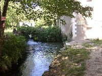
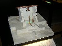
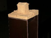
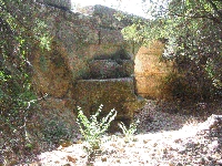
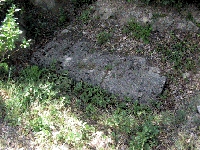
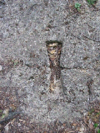
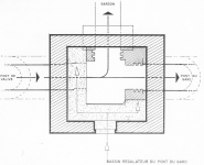
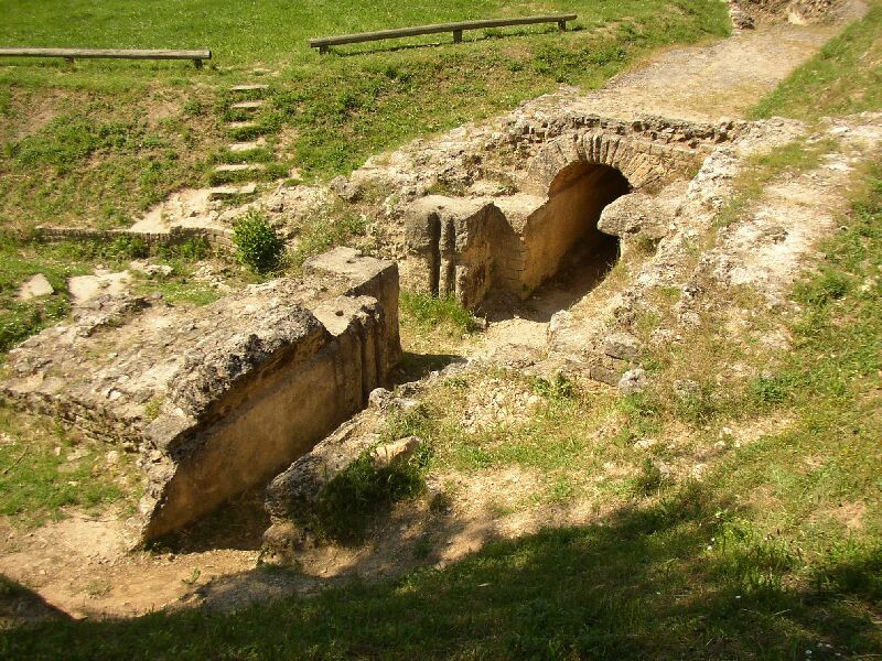
Regulation basin near Uzès
Walking down the left bank of the Alzon to the south one reaches sports fields below which the first traces of the aqueduct have been found some years ago. Continuing south, the conduit appears along the southern slope of the valley. It runs into a spectacular, square basin of 2.2 x 3 x 1.6 m which is one of the two regulation basins of the aqueduct that have been found to date. Originally, the basin was covered in a small building. The basin has conduits connecting into it from three sides, and a wall on the side of the hill. These are canalization openings of the entrance and exit of the aqueduct, and a diversion channel on the river side. Vertical blocks (jambs) with two vertical grooves on the inner faces flank the exit conduit of the aqueduct and the diversion exit towards the river. These were meant to guide wooden sluice gates that could be set at a certain level to control the amount of water entering the aqueduct downstream. Excess water from the spring could be diverted to the Alzon river. A circulation ledge of ashlars lies on top of the walls and channels and allowed inspection and maintenance. The whole basin was set in a small building. This structure was necessary to regulate the amount of water produced by the spring, which could vary with time, to be able to close the downstream section of the aqueduct for maintenance, and maybe for fine-tuning the flow of water in this leg of the aqueduct (see "a sectioned aqueduct?"). Notice that no sinter deposits occur in this section of the conduit. The opus signinum on the wall and the thin layer of red paint are perfectly preserved.

Conduit along the Alzon

Beyond the ruins of a mill, some 150 metres downstream from the regulation basin, a section of the conduit along the hillside is well preserved. The conduit is build in masonry as usually, but is partly set in a trench excavated in the hillside, mostly L- shaped but in a U-shape where low spurs of the hill had to be crossed. opus signinum covers the walls, with opus signinum "quarter rounds" beading in the corners of the channel connecting the lower wall to the channel floor. Locally, the red paint coating of the conduit is well preserved. There is no sinter deposit.

Conduit in les Arabades and les Béringuières

North of the D 981 between St Maximin and Argilliers are two sites, at les Arabades and les Béringuières, where the conduit can be seen trough the collapsed vault. Here a deposit of "brown sinter" is visible on the conduit walls.

Bornègre bridge and conduit

The Bornègre bridge is a bridge of three arches in ashlar masonry crossing a minor dry creek with steep banks. The conduit and the top of the bridge are missing, and the voussoirs of the arches are exposed, some with deep fissures due to use of the bridge by carts after the conduit had been demolished in the middle ages. The bridge is small but interesting, since it seems to have an excessively size and sturdiness for such a small innocent creek, with three arches and cut-waters on the upstream side of the pillars, and square buttresses on the downstream side. The reason is that this innocent looking, dry gorge is a "gouffre", and the local population knows how temperamental this can be. A short distance upstream in the gorge is a small cave which is the exit of a huge cave system filled with water like an inverted siphon. After heavy rain, this siphon become suddenly active and a tremendous torrent of water can exit through the cave opening, suddenly changing the dry creek into a raging torrent of 5 m3 per second. This was apparently known to the Roman engineers who designed this bridge to withstand exactly such events. Notice that some of the voussoirs are numbered, and that curtains of sinter on the pillars indicate that the conduit was leaking here, or that water was tapped. It is from this point on that the sinter deposit starts.

Upstream from the bridge a short section of the buried conduit can be visited. It has the typical size and shape of the Nîmes conduit, with ledges on the walls that carried the formwork for construction of the vault. The opus signinum on the walls and circles in the corners are covered with a thin deposit of sinter.

To reach bridge and conduit, turn off the D981 on the D 3bis towards Argilliers. after 250 m in a sharp curve to the right, turn left on a dirt track; follow this up and park. The creek and bridge are to the west from here.

Bridge of Roc-Plan in Vers

Two aqueduct bridges are visible here, one to the left of the entrance to the SYLEX quarry offices, the second 50 m to the right of the entrance. The upstream bridge is 12m long and 4m high and has three arches, the centre one in ashlar masonry. Both bridges have skewed arches, where the pillars are set oblique to the long axis of the bridge. This kind of arrangement is made when a stream approaches a bridge obliquely; pillars set at right angles to the bridge would be exposed too much to the force of the stream. Oblique openings avoid this problem. The bridge has buttresses on the pillars and massive sinter deposits on the outside. The downstream bridge is slightly smaller with three skewed arches.

Bridge of Coste-Belle (or Clos de Melet) in Vers

The gully of Coste-Belle is traversed by a small 30m long bridge of four square openings. The conduit is here covered with flat slabs instead of a vault. The bridge is on private property.

Clos des Touillers

At X77.28, Y3187.18 a nice manhole is visible in the covered aqueduct. This site is in dense vegetation with narrow tracks, and not easy to find.

La Lône arcade (Pont de la Lône)

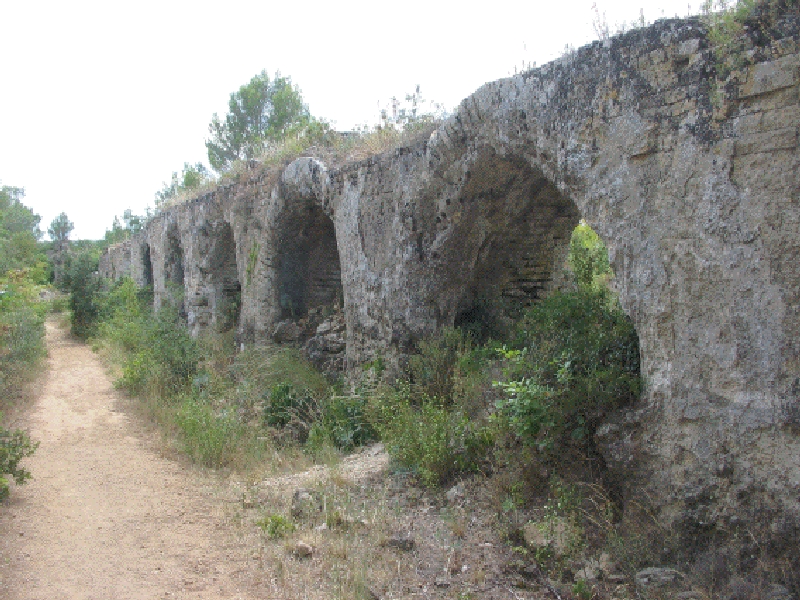
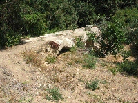
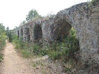
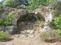
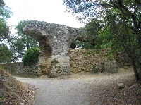
Pont de La Lône arcade
The Pont de la Lône starts close to Clos des Touillers. It consists of two wall sections at the ends, a series of 8 tall arches with buttressed pillars in the centre, 28 arches on the upstream side and 3 on the downstream side without buttresses. Although the arcade is built in concrete faced with courses of "petit appareil", the buttressed pillars rest on ashlar masonry bases. These are set up as two courses of blocks connected with clamps. The lower ones still show the holes that were used to wedge the upper blocks in place with iron bars. The top ones have a cross-shape. In Roman times the arcade already showed signs of instability, and many arches have been walled up to stabilize the bridge, also because water in the conduit rose higher than expected when the bridge started functioning. On the right-hand side of the first section of the bridge, a wall was set against it to stabilize the structure. Nevertheless, a section of conduit has fallen here at an early date. Massive sinter deposits cover the sides of the arcade, partly due to leaking but also to diversion of water for irrigation by local farmers in the latter days of the operation of the aqueduct. In the downstream section of the arcade, one of the arches shows evidence for opus signinum repairs on the sinter, probably an attempt in the 4th-5th century to repair the aqueduct. The southern abutment of the arcade is set directly against that of the Font-Ménestière bridge.

Font-Ménestière bridge

This bridge straddled the pass which is now crossed by the railway and the main Rémoulins-Uzès road. It was a bridge of probably two tiers, 300m long and up to 20m high. Almost nothing remains of the bridge. Pillar foundations of ashlar masonry, the blocks connected by clamps, can be seen on the slopes at the upstream and downstream sides. The bridge was built on soft marl and probably succumbed early, after which the remains were removed. There are some indications that the last remains of the bridge were blown up in the last century when the railway line was built. Excavation of the pillar basis has shown that there was indeed a bridge here and no inverted siphon.

The remains of the bridge on the south side of the D 981 are reached by parking at the top of the pass next to the railway, crossing the road and entering the track that is closed by a chain. Turning sharp left, a track goes up to some steps which are the start of a track along the pillar foundations to the abutment of the Pont Roupt.


Detailed map of the trajectory of the aqueduct near the Pont du Gard. Numbers are UTM coordinates, WGS84 datum (aqueducts in green)

Pont Roupt arcade

Where the downstream end of the Font-Ménestière bridge approaches the ground surface, a new bridge starts after a sharp curve. This bridge is known as the Pont Roupt, broken bridge in Occitan. The bridge is divided into three sections with slightly different directions, forming an open S-shape. The arcade consists of bridgehead walls and 37 arches of up to 7.5 m high. The first upstream section has 14 arches with buttressed pillars set on ashlar masonry bases, like the La Lône arcade. The central section has 13 arches, three of which have buttresses. The central part of the arcade gives the structure its name, since most of the pillars and arches have fallen onto the steep slope to the east. This may be due to the unstable soil on which the arcade was built, as indicated by the fact that again many of the arches are walled up. The third downstream section has 10 arches of which 4 have buttresses. This leg starts with a tall broken arch that looms over a hollow road. The road is at the same level as the castellum divisorium of Nîmes, indicating how shallow the slope in the final section really is. The imposts of the arches of this section are at different levels due to the gradually decreasing aperture of the arches downstream. Again, several of the arches are walled up here. Sinter deposits on the arcade and below some of the arches are massive.
The Pont Roupt can be reached by parking at the junction of the D 981 at the top of the pass where the D227 branches off to Vers. Cross the D 981 and walk up the path behind the chain; this goes straight up to the point where sections 2 and 3 of the Pont Roupt meet, at the large broken arch.

Valive arcade (Pont de Valive)

A low wall separates the Pont Roupt from the next bridge section, the Valive arcade of 55 low arches. The arcade has the same structure as the previous ones and is largely ruined. Here, some buttresses were apparently added when construction of the arcade was already in progress, since the tops of the buttresses are connected to the masonry of the bridge but the lower part is set against it. Sinter deposits are thick on the sides of the arcade.

Regulation basin

(presently covered)
A regulation basin has been excavated at the end of the Valive bridge. It had a similar structure to the basin at Uzès, and water was diverted down the slope towards the Gardon here. A major difference is that the basin is heavily encrusted with sinter, which may give important information on how the basin was used. The basin is presently covered to avoid damage.

Originally, the first arches of the Pont du Gard started shortly after the basin, but this section of the bridge was destroyed early on by stone robbers. The foundations of this part of the bridge were removed in the 18th century to build the road bridge that flanks the Pont du Gard. Several arches and an abutment wall, 360 m long in total, have disappeared.


==> For a description of more visible remains, see next entry <==

Cees Passchier en Wilke Schram

HOME More literature on more aqueducts Last modified: March, 2007 - Webmaster
(wilke@romanaquaducts.info)


Overflow of Eure source

First appearance

The regulation basin

The exit of the basin

View on the basin

Reconstruction

Basin house

Opus Signinum
and quaterrounds

The Bornegre bridge

Cutwater on the bridge

Detailed map

Pont de la Lône arcade

Broken arch of the Lône

Foundation Ménestière

Pier foundation and
dovetail clamp

Arch of the Pont Roupt

Tallest arch of Pont Roupt

Regulation basin