Nîmes 3 Pont du Gard

Roman aqueducts: Nimes (France) Nimes - COLONIA AVGVSTA NEMAVSENSIS
For the photo's, see below
Home / the complete website

Part 3: The Pont du Gard

This section is one of a series of 4:
  • Part 1: Introduction
  • Part 2: From Uzès to the Pont du Gard
  • Part 3: The Pont du Gard
  • Part 4: From the Pont du Gard to Nîmes
Each part has its own maps and photo's (see below)
Technical data are available in part 1, 3 (Pont du Gard) and 4
The literature list is present in part 4
For the photo's , see below.
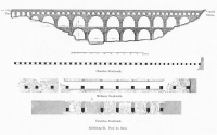
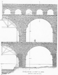
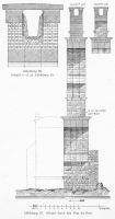
The Pont du Gard is the largest and most harmonious aqueduct bridge in the world, nearly 50 metres high and 350 metres long, with arches up to nearly 25 m wide and 19 m high, 50,000 tons of limestone ashlar masonry shaped into a filigree geometry that seems to be light and airy. It is built at the only suitable point for the aqueduct to cross the Gardon river, upstream from the plains and where the valley of the Gardon is nevertheless narrow with steep sides, and the hills relatively low. The Gardon runs most of the year in a gully 20m wide and 10 m deep, but there is a flat flood plain on the south side so that in flood the river has a much wider bed.

The Pont du Gard was built in three tiers here, in essence three bridges on top of each other, which gives there structure great lateral stability. The two lower tiers have wide arches directly above each other, so that the piers of the second tier rest on those of the first one. The spans of the arches belong to the largest ever attempted by Roman engineers. The span is variable, with the widest one spanning the gully in which the Gardon runs in summer. The third tier is in smaller arches with pillars resting as much as possible on the pillars or spandrel sides of the larger arches below, 3 arches of the third tier to one of the lower ones. Only on the widest arch of the lower tiers, four arches had to span the gap which places on pillar on the centre of the arch of the second tier. Above the last, upstream arch of the second tier there are only two arches of the third tier. The whole bridge is of the Tuscan order with simple mouldings along the imposts and corniches.

Because of the variable width of the arches, the imposts are at variable height on both sides of the pillars, the widest arches of the second tier determining the minimal height of those pillars. The width of the piers of the first and second tier also vary between 4.4 and 4.7 metres, the widest piers being the ones supporting the widest arch over the Gardon. In order to reduce weight, the third tier had to be as low as possible while still reaching the level of the conduit, and this was achieved by arches of all the same width, producing imposts all at the same level, while the necessary variation in position due to the variable width of the lower arches was reached by varying the width of the pillars between the arches. The fact that the third tier seems rather solid and heavy is partly a consequence of the geometry of the lower arches, but may also be a precaution against deformation of the conduit on the bridge by providing a massive, solid channel substructure.
All in all, it is difficult to imagine a more effective way to bridge this gorge.

The Pont du Gard is not straight, but has a slight curvature towards the upstream side. In the past it was thought that this was a subtle addition of the architect to give the bridge some support against the floods of the Gardon, but a more accepted reason is nowadays that the curvature has grown in the course of the ages due to the stronger heating of the southern face of the bridge by the sun. This causes daily expansion and shrinkage, but also a gradual change in shape of the whole structure. The thickness of sinter in the conduit is also higher on the sun-lit side.

The lowest tier has its foundations on solid rock of the flood plain, and not in the river as other aqueduct bridges. The pillars of the lower tier are therefore not often flooded, increasing its chances of survival. It is even possible that this gully was deepened on purpose when the bridge was built. Nevertheless, the pillars of the lower pier have cut-waters to face the "gardonnades", the infamous floods of the Gardon. In 1958, for example, the entire first tier was flooded up to the base of the second tier. A modern bridge in Rémoulins was washed away (100 m south of the present road bridge; the abutments with columns are still visible), but the Pont du Gard withstood the onslaught.

Some numbers

Greatest length 275 m
Greatest height above the lowest river level 48.77 m
Weight approximate 50,000 tons
Conduit originally 1.25 m wide and 1.85 m high (now 1.7 due to sinter concretions)
Conduit walls 0.85 m wide


Unit 3rd tier 2nd tier 1rst tier
Length ¥1 (m) 270 243 139
Height (m) 7.4 19.5 21.87
Width (m) 3.06 4.56 6.36
# of arches 35 11 6
Span ¥2 (m) 4.8 ¥3 24.52 - 15.5 24.52 ¥4 - 15.5
Tier width ¥5(m) 3.1 (mean) 4.4 - 4.7 4.4 - 4.7
Width of voussoirs (m)   1.52 1.6

¥1 length of tiers is measured from face to face of the openings
¥2 measured in the intrados
¥3 4.8 m is 16 Roman feet
¥4 distance between centres of the piers for the widest span: 29,1 m
¥5
- originally the 3rd tier had three more arches and was 287 m long
- 2nd tier: from N to S the spans are (m) 11.9-19.2-18.9-19.2-24.5-19.1-19.1-18.1-15.7-15.7-15.7
- 1rst tier: From N to S the spans are (m) 19.2-24.5-19.1-19.1-18.1-15.7

Architectural details

The piers are built of giant ashlar courses, with single blocks of up to 2 m3, weighing up to 6 tons each. The rest of the bridge is also built of ashlar masonry, except the upper parts of the arches of the third tier which are in rubble masonry faced with "petit appareil". The arches are built in parallel rows of voussoirs, four for the lower tier and three for the second. This was probably done to be able to use relatively light centrings which could be shifted sidewise and reused three of four times. It also gives the bridge some flexibility since relative motion is possible between sub-arches. The 7th, 8th and 9th voussoirs counted from the imposts are wider than the others and stick out in the intrados. They were the last voussoirs that could be laid on the imposts without using a support, and they carried the centring to build the crown of the arch. On some blocks in the intrados one can still see the stonemasons' marks for positioning of the blocks on the centrings. Either simple Roman numerals counting up from the extruding voussoirs; I,II,III,IIII,V,VI,VII (notice IIII instead of IV which was invented in the Middle Ages). Other marks are set in nice smoothed squares marking the sub arches; FR D II (FRONS DEXTRA II - right outside II); MI (MEDIVM III - middle III); FR S I (FRONS SINISTRA I - left outside I). The piers of the second tier have bounding blocks that protrude and may have been used to carry scaffolding. Also in other parts of the bridge and spandrels, some blocks extrude for the same purpose.

On the cutwater on the right bank of the Gardon, on the 6th block from the top is an inscription that probably reads MENS/TOTVM/CORIVM. If this is correct, and if the first word is an abbreviation of Mensum, it could mean "the whole skin (facing of the bridge) has been measured". This could be a mark from the original builders. In any case, the style of the letters is of the same age as the aqueduct.

The conduit was modified while the bridge was in use; the walls of the conduit were raised by removing the cover slabs, adding a row of ashlars of about 46 cm thick to the top of the wall, and replacing the slabs. The effect can be seen from the outside and from a join between the lower and upper part of opus signinum on the conduit wall. A very thick layer of sinter covers the walls of the conduit.

The conduit on top of the third tier is covered by slabs of 1.0 x 3.65 x 0.35 m, each weighting more than two tons. The upper surface is slightly sloping in both outwards to allow drainage of rainwater. The reason that slabs were used rather than a concrete vault as on the rest of the monument is that a vault excerts a lateral push which is no problem when the conduit is buried, but problematic on top of the bridge where no support from the sides is possible. In Fréjus, the bridges are covered with a vault, but here the specus is only two Roman feet wide, not four, and the conduit walls are thick. A solution would therefore have been thicker conduit walls, but his would have increased the weight of the third tier and the pressure on the arches of the second tier too much. In the aqueduct bridge of Metz over the Moselle, the problem was solved by building a double conduit with smaller vaults, but this was no option here since with the minimal slope of the conduit a doubling of the channel would have slowed the flow of the water too much by friction against doubled surface of walls. Again, the solution chosen is the only reasonable option here.

Later history

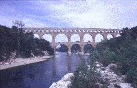
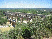
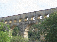
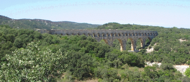
The Pont du Gard seen from SE
The Pont du Gard is not set in densely populated area, and it therefore survived for a long time without damage. Local monks started to remove some of the stones from the sides of the bridge, notably on the upstream side of the conduit where the third tier was extended in a series of arches, but they probably shied way from removing stones at an altitude of nearly 50 metres. The daring design of the bridge therefore also saved it from pillagers of building stone. For ages, however, the bridge was used as crossing of the Gardon, being the only bridge across the river. Unfortunately, there is only a gap of 70 cm between the pillars of the second tier and the edge of the corniche of the first one, and at some time in the 14th century someone decided to take drastic measures; the pillars were excavated significantly on the upstream side of the bridge, and small platforms added to the pier to allow pack animals and even carts to pass. This significantly weakened the structure of course, and it seems a miracle that the bridge did not fall. In 1702 the gaps were filled to restore stability, and in 1743 the engineer Pitot built a road bridge on the downstream side of the Gardon against the Pont du Gard. The gaps in the piers were then filled in again. The bridge used local stone, and even some of the foundation blocks of the upstream low part of the Pont du Gard itself. As a result, it seems to be an integral whole with the Roman bridge.

Viewing the Pont du Gard

The best place to see the bridge from a distance is at the panorama point on the left bank of the Gardon, SW of the bridge (indicated by signs). Another viewpoint is on the top of the right bank. The bridge can be see from other tracks all around, and with a guide, the conduit can be crossed. It is no longer allowed to walk on the cover slabs which used to be an interesting but dangerous experience.

The Pont du Gard has always made an impression on those who saw it. Here is what Jean-Jacques Rousseau wrote at the Pont du Gard (Confessions I, book 6)

"Après un déjeuner d'excellentes figues, je pris un guide et j'allai voir le Pont du Gard. C'était le premier ouvrage des Romains que j'eusse vu. Je m'attendais à voir un monument digne des mains qui l'avaient construit. Pour le coup, l'objet passa mon attente et ce fut la seule fois de ma vie. Il n'appartenait qu'aux Romains de produire cet effet. L'art de ce simple et noble ouvrage me frappa d'autant plus qu'il est au milieu d'un désert où le silence et la solitude rendent l'objet plus frappant et l'admiration plus vive, car ce prétendu pont n'était qu'un aqueduc. On se demande quelle force a transporté ces pierres énormes si loin de toute carrière et a réuni les bras de tant de milliers d'hommes en un lieu où il n'en habite aucun. Je parcourus les trois étages de ce superbe édifice que le respect m'empêchait presque d'oser fouler sous mes pieds... Le retentissement de mes pas sous ces immenses voûtes me faisait croire entendre la voix de ceux qui les avaient bâties. Je me perdais comme un insecte dans cette immensité. Je sentais, tout en me faisant petit, je ne sais quoi qui m'élevait l'âme et je me disais : "Que ne suis-je Romain !"

Cees Passchier and Wilke Schram

==> For a description of more visible remains, see next entry <==

HOME More literature on more aqueducts Last modified: February, 2016 - Webmaster
(wilke@romanaquaducts.info)


Pont du Gard in the 1980s

View from south east

Pont du Gard drawing

Details of Pont du Gard

Cross-section

Numbers on the voussoirs

Piers of the second tier

View from south-west

2nd and 3rd tiers

PdG in tricolour