Nîmes 4

Roman aqueducts: Nimes (France) Nimes - COLONIA AVGVSTA NEMAVSENSIS
For the photo's, see below
Home / the complete website

Part 4: Downstream end of the Pont du Gard


This section is one of a series of 4:
  • Part 1: Introduction
  • Part 2: From Uzès to the Pont du Gard
  • Part 3: The Pont du Gard
  • Part 4: From the Pont du Gard to Nîmes
Each part has its own maps and photo's (see below)
Technical data are available in part 1, 3 (Pont du Gard) and 4
The literature list is present in part 4
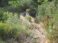
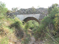
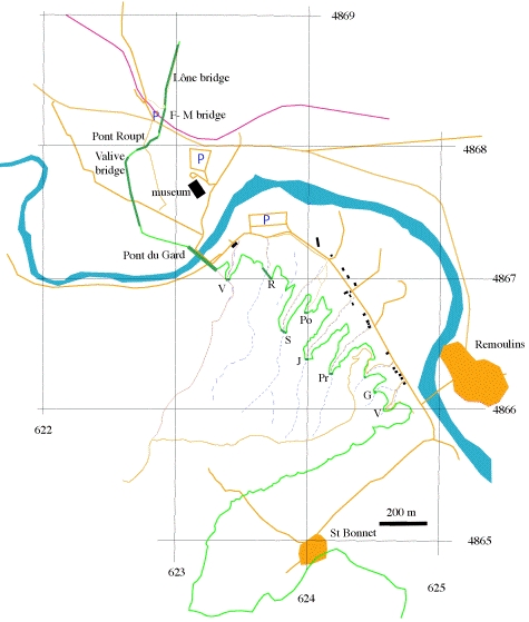
The upstream end of the Pont du Gard has been destroyed, but its downstream end is intact except for the top of the conduit walls and the cover slabs which have disappeared. The tunnel at this spot is not Roman but a 19th Century attempt to "revive" the Pont du Gard. The Roman conduit makes a gentle bend to the south at the end of the bridge to follow the hillside. The top is nicely polished by countless generations of tourists who walked and sat here, showing the masonry of the wall, the opus signinum layer, and the thick sinter deposit.

The bridges of the Forest of Rémoulins

The next few kilometres from the Pont du Gard to Rémoulins, the "Forest of Rémoulins" is marked by rough broken terrain where the aqueduct had to cross 12 narrow, steep valleys, locally known as "combes". The aqueduct was mostly built along the hillsides, and bridges of various size and shape were used to cross the valleys.
In this section, the conduit was built mostly in an L-shaped cutting in the hillside, the hill being used as one wall of the conduit while a rubble masonry wall formed the other side. In some cases, probably where the rock wall was unstable, a wall was built against it as well. The bridges vary from one with two tiers, to wall-like structures with culverts, depending on the size of the valley, the anticipated force of the stream in it, and the possibility that people (and flocks) had to pass beneath it. The area close to the Pont du Gard is gallery forest, similar to a tropical rain forest in feel and smell, while lower down the vegetation is typical "garrigue"; low, thorny, impenetrable but fragrant vegetation on rough, broken limestone terrain. Some of the bridges and most of the conduit are slowly being covered by the vegetation. Because of the dense vegetation, nearly all bridges are best reached by walking in along tracks along the bottom of the valleys from the D 981 (see map).


Detailed map of the trajectory of the aqueduct near the Pont du Gard.
Numbers are UTM coordinates, WGS84 datum (aqueducts in green)


V Valmale bridge R Combe Roussière S Sartanette bridge Po Ponceau bridge
J Combe Joseph Pr Pradier bridge G Combe Gilles bridge V Vallon 11

Combe Valmale bridge

This bridge of a single arch with 2.95 m span (10 Roman feet) is built in rubble masonry and faced with neat courses of petit appareil. The arch has collapsed and the facing stone was stolen from the upper parts of the abutments, but the lower parts were recently excavated and shine like new. Both abutments have open bends where they join the conduit on the hill slope on both sides. The bends and the abutments halfway to the arch are buttressed. A nice simple moulding marks the imposts. There are no supporting walls on this bridge (compare with other bridges, below).

This bridge can best be reached from the right bank of the Gardon at the downstream end of the Pont du Gard, passing trough the 19th Century tunnel. The conduit runs round the hill and can be picked up directly behind the tunnel, and followed to the bridge. The conduit is marked by sparse ruins and hedges.

Combe Roussière bridge

This was originally a two tier bridge, 25m high and 100 m long across a steep valley. Only the abutments of the second tier and the foundations of two pillars of the first tier are left. The abutments are well preserved, build in rubble masonry faced with petit appareil courses. The downstream abutment has a conduit in which a layer of opus signinum was found on top of the sinter in the channel, apparently a late (4th-5th Century) attempt to restore the aqueduct.

This bridge can best be reached from the Valmale bridge by following the trace of the conduit downstream. There is not much left of the conduit, but the path is marked by hedges where it is gone. This part of the conduit was strongest encrusted with sinter, with only 27cm width left for the water when the aqueduct stopped operating. There is a nice view of the Pont du Gard halfway to this bridge.

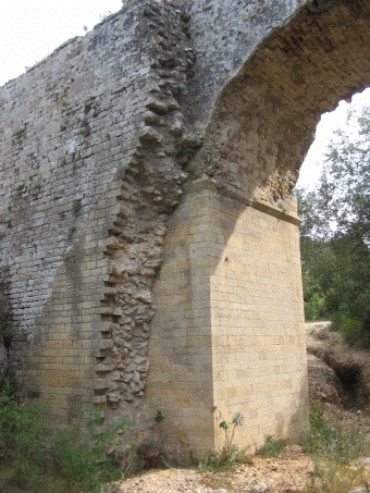
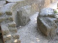
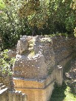
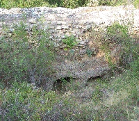
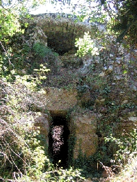
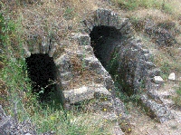
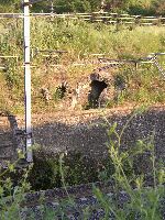
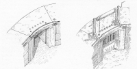
Sarnette bridge with supporting wall

Sartanette bridge

This is an impressive bridge, 32m long, 8 m high and of one arch, similar to the Combe Valmale bridge, but nearly completely preserved. The walls of the bridge were doubled to support the conduit walls shortly after it was built, probably at the same time that the conduit was raised. Since these support walls are partly broken away, the structure is now very clear.
This bridge can be reached from the Combe Roussière bridge but the path is rather overgrown. It is best be reached from the main road (D981) from the point where the cycle path to the Pont du Gard starts, opposite a Hotel. Follow the main path at right angles to the D981

The Ponceau

('small bridge')
This bridge was only discovered in 1987. It is a low bridge, 2.5 m high where the conduit rests on large stone slabs which cover three culverts with upstream miniature cut-waters. The bridge is now again heavily overgrown and the upstream cut-waters are covered with soil.

This bridge can be reached from the same point as the Sartanette bridge path, at the beginning of the cycle track, but instead of following the main path one should branch left where the fields with scattered trees stop and the garrigue starts, entering the next valley south.

Combe Joseph bridge

This low bridge is much ruined and overgrown. It has one singe arc of 4.1 m and supporting walls, like the Sartanette bridge. It is interesting since here the raising of the conduit walls can clearly be seen, with a layer of opus signinum on the lower part of the wall which was extended upwards when the wall was built up.
This bridge can be reached along a track in a valley that starts behind a shed on a deserted industrial area

Combe Pradier bridge

This bridge of a singe arch is even more overgrown than the previous ones, but is interesting because of the complex structure of the arch. The original arch was filled with an internal one, narrowing the span. In this space, a square conduit built of ashlars was later inserted. A large block with hoisting point can be found nearby.
The bridge can be reached along a badly gullied track that starts from a short stretch of road closed by a chain next to an isolated house at a junction where a minor road also branches off the D 981 in the opposite direction.

Combe Gilles bridge

This is a bridge of one arch, but badly overgrown and hard to reach.

Vallon 11 section

Behind the curve in the road to the reservoirs of Rémoulins lies a stretch of conduit, in a curve against the rock wall. The L-shaped excavation of the hillside is smooth and a thin veneer of opus signinum and sinter marks the other wall of the conduit; masonry has disappeared. This section is hard to reach through dense vegetation.

St Bonnet church

This fortified church is largely built of sinter and stones from the aqueduct conduit close by.

Sernhac tunnels

The Sernhac tunnels are strange since there was no real need to build them. A short detour could have led the aqueduct around the rock that contains the tunnels. However, the area was already a quarry in Roman times, and the architect was apparently weary of the conduit being damaged by quarry operations. Two short tunnels were therefore dug here behind the quarry. Unfortunately, medieval and later quarrying has damaged part of the tunnels.

Perotte tunnel (northern tunnel)

This tunnel is 2 m high, 2.5 m wide and 80 m long. The entry area from the quarry has been dug a way by later quarrying, but parts of the wall of the conduit, opus signinum and sinter can still be seen. The conduit was not covered inside the tunnels. The tunnel has three manholes that were used to dig the tunnel in two directions in qanat fashion. The walls of the tunnel show tool traces, the curved marks being made by a man swinging an axe; the curvature therefore indicates the direction of digging. Where teams met, the curvature of the digging traces reverses, and there are irregularities in the walls because of mistakes in direction of digging. Apparently, the tunnels were first dug by two men on their knees to make a low tunnel to connect with the team digging from the other side, after which the tunnel was extended upwards and finished. The whole work took probably approximately two months. All this can be read from the traces on the walls. At regular distances, niches in the wall were made that served to place oil lamps for lighting. The niches are in the centre of the wall and near the ceiling, and are closest together furthest away from the manholes and the end of the tunnel. The density of these niches has been used to estimate the original length and shape of the tunnels in the area of later quarrying. Some niches still show traces of soot left by the lamps.

Cantharelles tunnel (southern tunnel)

This tunnel has two manholes and is 63 metres long. The first part in the quarry has been destroyed. This tunnel is much wider than the Perotte tunnel, and seems to be less well designed and executed. Several false starts and meeting points can be seen.
To reach the tunnels, follow signs 'aqueduc romain' in Sernhac. The tunnels lie north of the village. After a double sharp bend in the track following an old quarry wall, a meadow is reached which can be used for parking and picnicking. The tunnels are to the west and southwest of here in the quarry walls.

Le Grès railway cutting

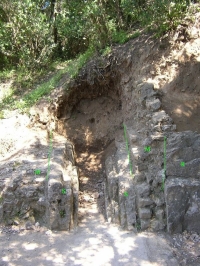
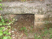
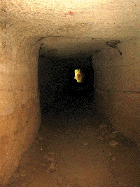
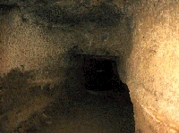
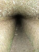
The two conduits at La Grès
Here, the railway line cuts the aqueduct conduit and an adjacent drainage channel. The southern one, with thick sinter deposits is the aqueduct channel. The northern one, of almost equal size, dips in the opposite direction and drained the "Etang" (shallow lake) of Clausonne which was crossed by the conduit. Both aqueducts lie two metres below the present ground level.
The site can be found just north of where the D 205 crosses below the A9 motorway. A road cross marks a junction where a country lane goes over the railway track to the west by a bridge. Park along this track and follow the top of the railway line embankment to the north for 30 metres (careful, steep!). Some steps lead down to the aqueduct sections.

Castellum Divisorium

The castellum divisorium of Nemausus, one of two presently known, lies behind a low fence on the east side of the Rue de la Lampèze at the foot of a hill. It consists of a circular basin, 5.5 m in diameter and 1.3 m deep surrounded by a walkway of stone slabs, 1.5 m wide. Behind the walkway is the wall of the building that originally housed the castellum, in petit appareil. Originally this wall was plastered and painted with dolphins and fishes which could still be seen when the castellum was discovered in 1844. A large slab on the north side of the walkway marks the original threshold of the entrance to the building.
The aqueduct entered the basin through a square opening, 1.2 x 1.2 m, set slightly oblique to the centre of the basin, probably in order to create a circulation in the basin. There are several holes in the slab covering the conduit, and a groove at the edge of the conduit. The function of these is unfortunately not yet clear.
On the opposite side of the basin are 10 openings of 30-40cm diameter, halfway up the wall that contained lead pipes of 30 cm diameter in pairs of two. Each pair of pipes was contained in a masonry channel. All lead pipes have, of course, been stolen long ago. In front of the holes of the pipes are three circular drainage holes in the floor of the basin where the water could be drained out of the basin into the sewers. There are also several enigmatic small holes that may have been used to fix gates or grilles.

The Castellum lies in the Rue de la Lampèze at the junction with the Rue d'Albenas. It is usually not possible to park here, and the Rue de la Lampèze is a one-way street which can only be driven in southern direction. The best place to park is in the Place de la Révolution, walking up the Rue de la Lampèze to the north to see the Castellum. The castellum is sign posted as "chateau d'eau".

Water distribution in Nimes

There is not much know about the water distribution in the Roman city of Nimes.
In a comparative analysis of the Roman water systems in Pompeii and Nimes, Clare K. Rasmussen made a new proposal for the water distribution system in Pompeii (Italy) with 14 water towers and a suggested position of the main water lines. This is supplementary to the ones made by Jansen (2002), Schmolder-Veit (2009), Olssen (2015), and Ohlig (2016), see this website, entry Pompeii.

An even more ambitious project, described in her master thesis, is the proposal for a water distribution scheme in ancient Nimes (France). For a map and an elaborate explanation, see below.

Cees Passchier and Wilke Schram

==> For a description of more visible remains, see the other entries <==

Nîmes - COLONIA AVGVSTA NEMAVSENSIS

Item Info
Length km
Cross-section m x m
Volume 35-38.000 m3/day
Fall 0,032 %
Period 2nd half 1C
Features
  • Regulation basins
  • Highest Roman aqueduct bridge
  • Castellum Divisorium


Proposal for a water distribution scheme in ancient Nimes
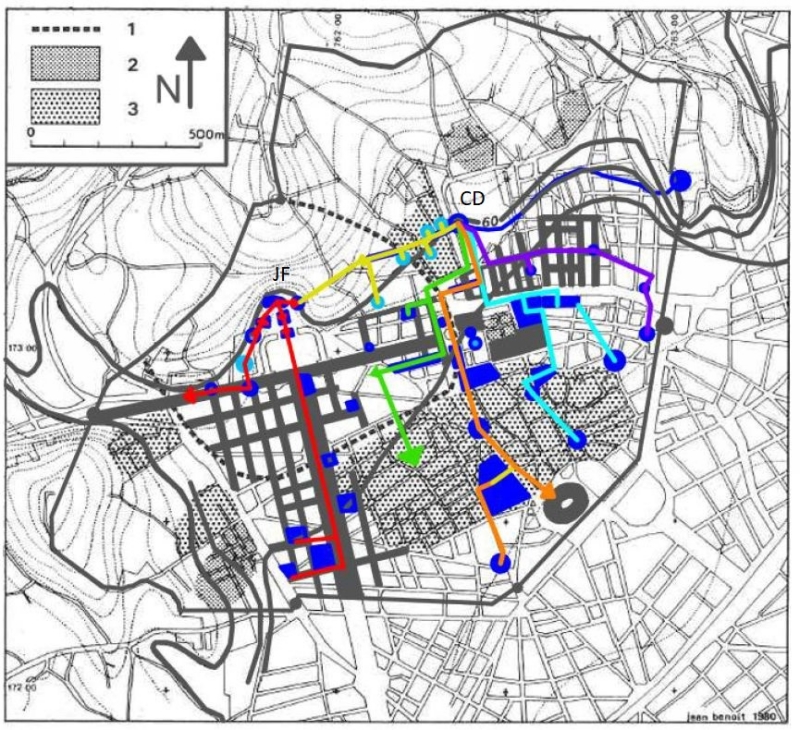
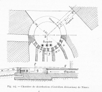
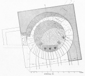
CD = Castellum Divisorium; JF = Jardin de la Fontaine
Urban Water Distribution Routes (in red, yellow, purple, green, and orange),
water related buildings (in blue), elevations and contour lines (in gray).
Drawing by C.K. Rasmussen (2017), Map by Fiches (1996)

A proposal for a water distribution scheme in ancient Nimes

Here we cite C.K. Rasmussen (2017) pag 55 - 59, figure 4.9 (see above) and chapter 4.5: Urban Distribution Scheme:

"The urban water system of Roman Nîmes has never been mapped, so I prepared a plausible hypothetical map of the water distribution routes based on an evaluation of in situ evidence and the layout of the city (see map above). By analyzing city maps, a catalogue of excavations by Jean-Luc Fiches, and topographical elevations, I have distinguished areas and buildings that would have been part of the urban water distribution scheme. My map has five water supply routes, which accounts for the 10 pipes being grouped together in pairs of two.

My first route (which is highlighted in yellow in the map) runs toward several domus style houses with extravagant mosaics. The houses are located due west of the castellum divisorium. Excavations have revealed piping from the castellum divisorium leading this way down Rue d’Albenas. Furthermore, the direction of the pipes points toward the Jardin de La Fontaine and the downward slope of elevation. Though the Jardin de La Fontaine had its own water supply from the native spring, the water supply for that sector of the city probably was supplemented by water from the castellum divisorium.

A second route (which is highlighted in green in the map) leaves the castellum divisorium and travels south down Rue de la Lampeze before turning west to service a domus on Rue des Bénédictins and a bath on Rue Pasteur. The remains of a subterranean channel located at Rue des Bénédictins confirm this route. The water supply line then turned south to service the blocks located on the eastern side of Avenue Jean Jaurés via a long underground canal of 150 m in length that was discovered at Place d’Assas. The canal was 2.30 m wide and 1.50 m deep, and would supply the central region of the city. This is supported by the remains of a canal, stamped pipes, and a basin near Rue Saint- Laurent.

A third route from the castellum divisorium (which is highlighted in orange in the map) would have serviced the south sector of the city. South of the castellum divisorium was the forum, the Maison Carree, and a few residential blocks. The Maison Carrée is a hexastyle temple that was dedicated to Gaius and Lucius Caesar, the adopted heirs and grandsons of Augustus. The Maison Carrée is one of the best-preserved Corinthian temples in the Roman world and exhibits precise Vitruvian proportions. I believe this route existed because of the collectors discovered under the Maison Carree, which was located just east of the forum. Also, just a few meters north of the Maison Carrée, a monumental canal was discovered underneath the streets.
Furthermore, the gradient of the terrain declines considerably from the castellum divisorium to the Forum, so it seems likely that the ancient engineers would have exploited this slope to keep the water flow at a constant rate. Just south of the Maison Carrée is the remains of a bath complex along Boulevard Victory Huge. The direction of this third route is further supported by the discovery of stamped lead pipes between the Maison Carrée and this bath complex. Finally, the last probable target of this route from the castellum divisorium is the amphitheater. It also had collectors beneath its floors. Moreover, I believe that the arena would have been supplied water from the castellum divisorium because of its axial position to the forum, Maison Carrée, and the castellum divisorium.

I have determined that a fourth route from the castellum divisorium (which is highlighted in cyan in the map above) would have led to the bathing complex located at Des Halles, just northeast of the forum complex. The baths are located down the slope from the castellum divisorium, thus it is evident that they would have been supplied water from the castellum divisorium. From the baths at Des Halles, the water supply route would head south to another bath complex and an aqueduct channel and then east to part of the drainage system. The water supply line would dump into the drainage system and be discarded past the Porte d’Auguste with other waste water.

The fifth water distribution route (which is highlighted in purple in the map) supplied the eastern urban grid. Remains of this grid along the Via Domitia are visible in the landscape today and I have outlined them on my map. The remains found in this sector of the city include hypocausts, hydraulic features, and irrigation canals, all of which indicate that this area of the city received water from the castellum divisorium. Furthermore, the elevations of this area are very flat and differ by about 1 m at most, making this route physically plausible.

Worthy of attention is the natural spring located on the northwestern side of the city, which I have determined was the source of a sixth (and separate) water distribution route (which is highlighted in red in the map above). This water route begins at the Jardin de La Fontaine. This area comprised a theatre, a nymphaeum, the Temple of Diana, a propylon structure, and the source of the native spring. The nymphaeum consisted of two exedrae basins that were fed by the natural spring. The foundation would have been rectangular, measuring 16 m by 20 m. The Temple of Diana, which is a misnomer, consists of complex niches, vaulting, and Corinthian style columns and pilasters. The function of this building is still unknown, but it is hypothesized to be another nymphaeum or a library.
This sixth water route runs west from the Jardin de La Fontaine down Quai de la Fontaine, as evidenced by canals found along this street. This allowed for the waste water from the Jardin de La Fontaine to be taken out of the city and disposed through the gate located at the western end of the Via Domitia. Also, this route from the Jardin de La Fontaine serviced the southern orthogonal layout of this city. This is supported by the remains of hypocausts, an aqueduct channel, and lead pipe that were discovered along Avenue Jean Jaurés. Water would have been supplied to the western side of Avenue Jean Jaures by stamped lead pipes found in this area. It is probable that the western water route followed the east-west streets and distributed water to the regularly planned blocks in this sector of the city."


From C.K. Rasmussen (2017): " A comparative analysis of Roman water systems in Pompeii and Nimes" (master thesis, all rights reserved)
For the footnotes, see the original manuscript.


Recommended literature :
  • O'Connor, C. 1993. Roman bridges. Cambridge University Press
  • Larnac, C, Garrigue, F. 1999. L'aqueduc du Pont du Gard. Les presses du Languedoc
  • Fabre, G, Fiches, J-L, Leveau, Ph, Paillet, J-L. 1992. The Pont du Gard. Water and the Roman town. Presses du CNRS
  • Fiches, J-L, Paillet, J-L. 1988. Nîmes. in: Die Wasserversorgung antiker Städte 3. 207-214. von Zabern.
  • Darde, D. 2005. Nîmes antique. Monum.
  • Granier, J. 1990. The Pont du Gard. Monaco.
  • Hauck, G. 1988. The aqueduct of Nemausus. McFarland.
  • C.K. Rasmussen (2017): A comparative analysis of Roman water systems in Pompeii and Nimes (Master thesis, on the web)
Recommended website : Le Pont du Gard (in French)
How to visit : see above
HOME More literature on more aqueducts Last modified: January, 2018 - Webmaster
(W.D.Schram@romanaquaducts.info)


Sharp bend with sinter

The conduit of the aqueduct

Combe Valmale bridge 1

Combe Valmale bridge 2

Bridgehead of Valmale bridge

Combe Roussière bridge

The Sartanette bridge N

The Sartanette bridge S

The Ponceau

Upstream of Ponceau

Culvert of the Ponceau

Combe Joseph bridge

Arches of the Combe Pradier

Central part of the
Perotte tunnel

Meeting point in the
Perotte tunnel

Remains of the conduit wallt

Meeting point

False start of digging teams

Traces on the wall

The two conduits at Le Grès

Two conduits near
the railway cutting

Inside the conduit at Le Grès

The Castellum Divisorium

The Castellum from inside

Drainage openings

Castellum Divisorium model

Tentative reconstruction

Castellum Divisorium model

Details of the inlet