| For the photo's, see below |
| Home / the complete website |
This section is one of a series of 4:
Technical data are available in part 1, 3 (Pont du Gard) and 4 The literature list is present in part 4 |
 |
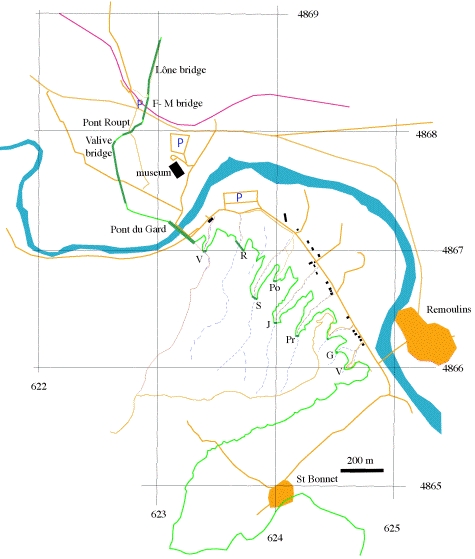
| V | Valmale bridge | R | Combe Roussière | S | Sartanette bridge | Po | Ponceau bridge |
| J | Combe Joseph | Pr | Pradier bridge | G | Combe Gilles bridge | V | Vallon 11 |
 |
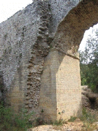
| Sarnette bridge with supporting wall |
 |
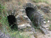
| The two conduits at La Grès |
| Item | Info |
|---|---|
| Length | km |
| Cross-section | m x m |
| Volume | 35-38.000 m3/day |
| Fall | 0,032 % |
| Period | 2nd half 1C |
| Features |
|
 |
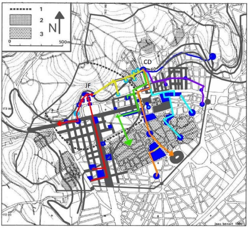
CD = Castellum Divisorium; JF = Jardin de la Fontaine Urban Water Distribution Routes (in red, yellow, purple, green, and orange), water related buildings (in blue), elevations and contour lines (in gray). Drawing by C.K. Rasmussen (2017), Map by Fiches (1996) |
A proposal for a water distribution scheme in ancient NimesHere we cite C.K. Rasmussen (2017) pag 55 - 59, figure 4.9 (see above) and chapter 4.5: Urban Distribution Scheme:"The urban water system of Roman Nîmes has never been mapped, so I prepared a plausible hypothetical map of the water distribution routes based on an evaluation of in situ evidence and the layout of the city (see map above). By analyzing city maps, a catalogue of excavations by Jean-Luc Fiches, and topographical elevations, I have distinguished areas and buildings that would have been part of the urban water distribution scheme. My map has five water supply routes, which accounts for the 10 pipes being grouped together in pairs of two. My first route (which is highlighted in yellow in the map) runs toward several domus style houses with extravagant mosaics. The houses are located due west of the castellum divisorium. Excavations have revealed piping from the castellum divisorium leading this way down Rue d’Albenas. Furthermore, the direction of the pipes points toward the Jardin de La Fontaine and the downward slope of elevation. Though the Jardin de La Fontaine had its own water supply from the native spring, the water supply for that sector of the city probably was supplemented by water from the castellum divisorium. A second route (which is highlighted in green in the map) leaves the castellum divisorium and travels south down Rue de la Lampeze before turning west to service a domus on Rue des Bénédictins and a bath on Rue Pasteur. The remains of a subterranean channel located at Rue des Bénédictins confirm this route. The water supply line then turned south to service the blocks located on the eastern side of Avenue Jean Jaurés via a long underground canal of 150 m in length that was discovered at Place d’Assas. The canal was 2.30 m wide and 1.50 m deep, and would supply the central region of the city. This is supported by the remains of a canal, stamped pipes, and a basin near Rue Saint- Laurent. A third route from the castellum divisorium (which is highlighted in orange in the map) would have serviced the south sector of the city. South of the castellum divisorium was the forum, the Maison Carree, and a few residential blocks. The Maison Carrée is a hexastyle temple that was dedicated to Gaius and Lucius Caesar, the adopted heirs and grandsons of Augustus. The Maison Carrée is one of the best-preserved Corinthian temples in the Roman world and exhibits precise Vitruvian proportions. I believe this route existed because of the collectors discovered under the Maison Carree, which was located just east of the forum. Also, just a few meters north of the Maison Carrée, a monumental canal was discovered underneath the streets. Furthermore, the gradient of the terrain declines considerably from the castellum divisorium to the Forum, so it seems likely that the ancient engineers would have exploited this slope to keep the water flow at a constant rate. Just south of the Maison Carrée is the remains of a bath complex along Boulevard Victory Huge. The direction of this third route is further supported by the discovery of stamped lead pipes between the Maison Carrée and this bath complex. Finally, the last probable target of this route from the castellum divisorium is the amphitheater. It also had collectors beneath its floors. Moreover, I believe that the arena would have been supplied water from the castellum divisorium because of its axial position to the forum, Maison Carrée, and the castellum divisorium. I have determined that a fourth route from the castellum divisorium (which is highlighted in cyan in the map above) would have led to the bathing complex located at Des Halles, just northeast of the forum complex. The baths are located down the slope from the castellum divisorium, thus it is evident that they would have been supplied water from the castellum divisorium. From the baths at Des Halles, the water supply route would head south to another bath complex and an aqueduct channel and then east to part of the drainage system. The water supply line would dump into the drainage system and be discarded past the Porte d’Auguste with other waste water. The fifth water distribution route (which is highlighted in purple in the map) supplied the eastern urban grid. Remains of this grid along the Via Domitia are visible in the landscape today and I have outlined them on my map. The remains found in this sector of the city include hypocausts, hydraulic features, and irrigation canals, all of which indicate that this area of the city received water from the castellum divisorium. Furthermore, the elevations of this area are very flat and differ by about 1 m at most, making this route physically plausible. Worthy of attention is the natural spring located on the northwestern side of the city, which I have determined was the source of a sixth (and separate) water distribution route (which is highlighted in red in the map above). This water route begins at the Jardin de La Fontaine. This area comprised a theatre, a nymphaeum, the Temple of Diana, a propylon structure, and the source of the native spring. The nymphaeum consisted of two exedrae basins that were fed by the natural spring. The foundation would have been rectangular, measuring 16 m by 20 m. The Temple of Diana, which is a misnomer, consists of complex niches, vaulting, and Corinthian style columns and pilasters. The function of this building is still unknown, but it is hypothesized to be another nymphaeum or a library. This sixth water route runs west from the Jardin de La Fontaine down Quai de la Fontaine, as evidenced by canals found along this street. This allowed for the waste water from the Jardin de La Fontaine to be taken out of the city and disposed through the gate located at the western end of the Via Domitia. Also, this route from the Jardin de La Fontaine serviced the southern orthogonal layout of this city. This is supported by the remains of hypocausts, an aqueduct channel, and lead pipe that were discovered along Avenue Jean Jaurés. Water would have been supplied to the western side of Avenue Jean Jaures by stamped lead pipes found in this area. It is probable that the western water route followed the east-west streets and distributed water to the regularly planned blocks in this sector of the city." From C.K. Rasmussen (2017): " A comparative analysis of Roman water systems in Pompeii and Nimes" (master thesis, all rights reserved) For the footnotes, see the original manuscript. |
| Recommended literature : |
|
| Recommended website : | Le Pont du Gard (in French) |
| How to visit : | see above |
| HOME | More literature on more aqueducts | Last modified: January, 2018 - Webmaster (W.D.Schram@romanaquaducts.info) |