Perge (Turkey)
Roman aqueducts: Perge (Turkey)
Aksu - PERGE
Perge
The city of Perge is situated 17 km east of Antalya, within the borders of Aksu. The important monumental structures of the city have been excavated since 1946 and due to the excavated sculptures,
the Antalya Museum has one of the richest collections of Roman sculptures.
 |
|
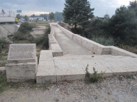
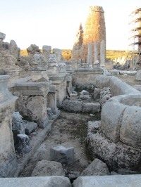
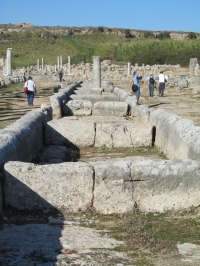
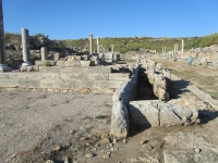
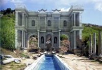
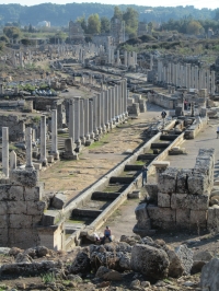
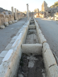
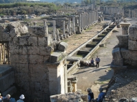
Cascading pools in the colonnaded street of Perge, seen from the acropolis hill.
|
Perge's history
Historians think that Perge was founded at the end of the Trojan war (1275 BCE) but a Hittite tablet found in 1986 showed that Perge was established before the Trojan war. According to philological
evidence the city was already a settlement in the 3rd millennium BCE. Some ceramic and stone finds indicate that the history of the settlement extends back in time to the Early Bronze Age.
The first settlement in the city was on the plateau to the north. The city developed and expanded in time over the southern plain. Perge, on the antique road from Bergama (Pergamum) to Side, owes
its importance and development to the Kestros, now Aksu river. The ancient river which does not followed the same course as today, but played an important role bringing rich fertile alluvial soil,
and provided important access to the city.
The fact that the people of Perge did not resist but welcomed Alexander the Great when he invaded the area in 333 BCE, shows that there were no walls to protect the city.
It is known that Saint Paul and his friends sailed from the harbor at Paphos in Cyprus to Perge in 46 CE. The integration of the city and the river is indicated on coins, reliefs, and the sculpture of the
river god Kestros on the monumental nymphaeum (ornamental fountain) at the southern foothill of the acropolis.
Among the famous Pergaeans, we know of Apollonius, the mathematician and astronomer (3rd c BCE), as well as Varus, the philosopher (2nd c CE) who, according to inscriptions, had a statue in the temple of Artemis.
Although many gods and goddesses were worshipped at Perge, Artemis held an important and special place. Her roots were deep in ancient history and she was called Wanessa-Preiia (Queen of Perge)
in the local language. The cult of Artemis Pergaia spread to neighboring countries; she was even worshipped overseas. The Artemis temple, often characterized by its beauty, size and magnificent architecture,
was built on top of a high hill but its location still remains a mystery.
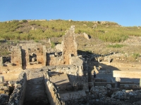
From excavations and investigations it is clear that Perge experienced three golden periods. The first, during the Hellenistic period (2nd - 3rd c BCE) represented by the great walls and towers which still
partly stand today. The second was during the Roman Empire in the 2nd and 3rd c CE represented by monumental structures which are still largely standing today: the theatre, the stadium, the bathhouses,
monumental fountains, and the agora. The last golden period was during the Christian period in the 5th and 6th c CE During this period Perge was a metropolitan centre and many churches were constructed.
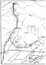
| Bridges |
Latitude |
Longitude |
| Saklisi | unknown | unknown |
| Egridere (about) | 36 59 08 N | 30 50 05 E |
| Ahmetal / Degirmen | 36 58 47 N | 30 50 07 E |
| Sogucaksu | 36 56 36 N | 30 49 35 E |
Two aqueducts
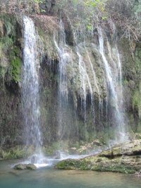
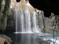
In the early days of Perge, water came from local springs, wells and rain water stored in cisterns. At a certain date the Kursunlu aqueduct was built to cope with the growing demand of water, probably
caused by the construction of a baths. This water came from the Kursunlu / Gelindusen river and was tapped close to the present Kursunlu waterfalls. This 11 km long aqueduct followed the sinuous
river and/or made use of not yet discovered tunnels.
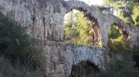
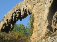
Three major bridges are known: the Saklisi bridge, now to a great extend in ruin, the Egridere bridge, a simple one tier bridge with a span of 11 m, and the Ahmetal / Degirmen bridge, 2 km NW of
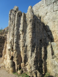
Perge's acropolis, the most magnificent and robust bridge. It is known that the Kursunlu / Gelindusen river is a karst river and its water is very calcareous. So it is not a surprise that the bridge is heavily
'overgrown' with calcareous deposits: nearly no building blocks of the bridge proper, can be seen today.
The main distribution basin of this northern aqueduct must have been somewhere near the northern baths.
Second aqueduct
On a later date a second and more capable aqueduct was built tapping water from the Duden river, near the present Dudenbasi waterfalls. According to G. Buyukyildircim, the channel followed the
first 6 km the riverbed and then turned to the east, made a detour N and E of the present airport and entered the Perge area from the south, where almost no remains are left.
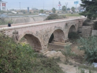
The most prominent part is the well-known Sogucaksu bridge, which can easily be seen N of the D-400 road from Antalya to the east, just before the junction with the road to Isparta. This ancient
Roman bridge was restructured in Seljuk times into a road bridge and in recently (2009 - 2010) heavily restored, according to the local information panel. The technical details of the bridge: length
50m, arch rise 9,50m, width 3,60m, width of the parapet 0,70m.
Along the course of this aqueduct and south of the D400, the remains of a series of water mills have been found from different time periods, probably fed by this aqueduct.
Water distribution
Although Perge had many water related structures like baths, nymphaea and street fountains, there does not exist (yet) a complete overview over its water distribution. Most striking, however,
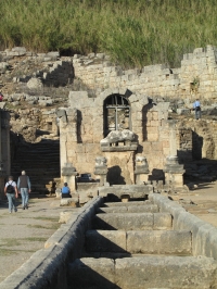
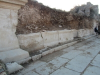
are the sets of cascading pools both in the middle of the N-S colonnaded street and of the E-W avenue, where the water plunged from one basin into the other.
These cascading pools might have been fed by the northern aqueduct that enters Perge from the northwest and splits into a south branch (on top of the city wall?) towards the northern baths,
and an eastern branch heading towards Hadrian's nymphaeum. East of the palaestra (wrestling school / sports ground) another branch that splits off from the main supply direction south,
crossed the west wing of the E-W colonnaded street by a bridge and continued after a zigzag course. But ... the above description is to a great extend hypothetical: as mentioned above,
we only know from some interesting elements without the greater picture!
 |
|
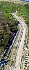
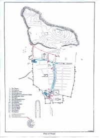
Map with the water structures in Perge. In red the hypothetical course of the water distribution (from: Buyukyldirim 1994)
|
Main elements
What were the main element (see also the map):
- The water distribution system within the city (channels and pipes), of which not so must can be said with certainty.
- Series of cascading pools, in the middle of the N-S road and in the E-W street. The former was fed by the Hadrian's nymphaeum at the foot of the Acropolis hills. Behind the front one
can easily discover the feeding channel,
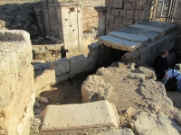
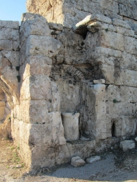
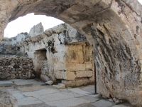
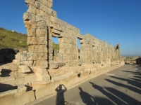
- At least six nymphaea: one adjacent the northern baths (just recently excavated), one in front of the palaestra, the Hadrian's nymphaeum with the Kestros sculpture in the north,
two nymphaea along the west side of so-called Septimius Severus square in between the Roman and the Hellenistic towers, and one close to the theater,
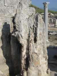
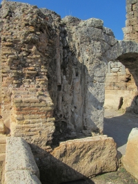
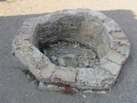
- At present three major distribution points are visible: one near the water bridge in the middle of the western colonnaded street, one at the west side of the N-S colonnaded street,
and one behind the nymphaeum F2 façade, all of them furnished with series of ceramic pipes and large layers of calcareous deposits, as the the Ahmetal / Degirmen bridge mentioned above.
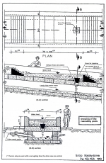
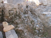
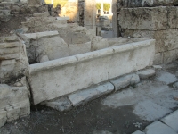
Under the cascading pools was a major drainage channel. There was a direct connection between the pools and the drain by means of a series of vertical holes, furnished with stone plugs,
which made it possible to dewater the pools, probably for cleaning and maintenance. Some pools were also equipped with horizontal holes and ceramic pipes to feed the houses and shops along the street.
Modern copies of the system of cascading pools can be found in cities like Tehran, Monaco and in � nearby Antalya, just opposite the Su-hotel, in between Minicity and Antalya Aquarium.
In conclusion
Imagine the sound of splashing water in a semi-arid area where the mean summer temperature by day is over 30 degrees Celsius. Even given the fact that only a part of the city has been
excavated and a thorough look into the water distribution system is missing until now, one thing is clear:
Perge must have been a city of water.
Wilke Schram
The introduction text is partly based on the folder: Perge ruins (nd)
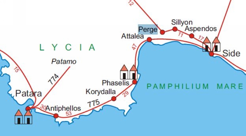
Cyprus and the Tabula Peutingeriana
The Tabula Peutingeriana (Peutinger map) is an itinerarium depicting the road network in the Roman Empire. The original map of which this is a schematic copy,
was last revised in the fourth or early fifth century. It measures about 0,35 m in height and 7 m in length. Dr. W. Bruijnesteijn van Coppenraet made
this outline (from: De Romeinse reisgidsen, 2006).
Distances in Roman miles (1482 m). Vignettes are Mansiones (official stopping places along Roman roads with (or without) some facilities).
| On map |
Modern name |
On map |
Modern name |
| Patara |
Gelemis |
Attalles |
Antalya |
| Antiphellos |
Habesos / Kas |
Perge |
Aksu |
| Patamo |
Unknown |
Sillyon |
Asar Koy |
| Korydalla |
Haciveliler |
Aspendos |
Belkis |
| Phaselis |
Tekirova |
Side |
Side / Selimiye |
Aksu - PERGE
| Item
| N-Aqueduct
| NW-Aqueduct
|
| Length |
11,350 km |
21,500 km |
| Cross-section |
m x m |
m x m |
| Volume |
21.000 m3/day |
84.000 m3/day (??) |
| Gradient |
0,4 % |
0,15 % |
| Period |
? |
? |
| Features |
- Bridge(s) with mass calcareous depositis
- Reconstructed aqueduct bridge
|
| Recommended literature :
|
- G. Buyukyildirim (1994): Perge kenti tarihsel su yapilari (Historical water structures of the city of Perge) (in Turkish)
|
| Recommended websites :
|
|
| How to visit :
| see maps above
|