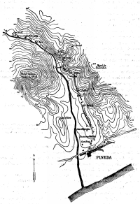
Ancient map with trace
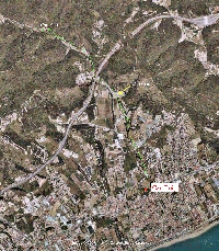
GoogleEarth image
Destination
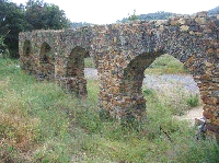
Can Cua 1
Can Cua 2
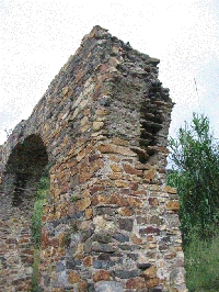
Broken arche
| For the photo's, see below |
| Home / the complete website |
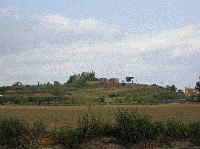
Near Pineda de Mar, a small coastal town in Catalonia, lie the remains of a small but interesting roman aqueduct. The aqueduct supplied a roman large villa
with water for irrigation at a site now occupied by a large ruined farm, "Can Roig" (the red house). Remains of more than 200 villas have been found
along the Catalan coast. The villa of Can Roig was probably used from the first to the fifth centuriy AD.
The aqueduct had a length of 3.5 km and followed the east side of the Pineda river. It started at a small dam in the river in a narrow part or 'congost'
of the valley, 200m upstream from a farm known as "Can Bufi" at 65 meters above sea level. It descended 40m to Can Roig which lies on a ridge
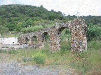
overlooking the sea. At Can Roig, the aqueduct filled a large basin. The aqueduct crossed four small creeks on arches before reaching the villa.
There were 20 arches in Can Palau, 7 in Can Cua and fewer in the other creeks. All have spans of 3-4 metres, and the bridges are less than 10 m high.
There are also locally walls up to 5 m high supporting the channel. The specus is 25-32 cm wide and about 20 cm high, and treated with opus signinum.
The aqueduct is rather steep, but there was no option to obtain the water lower down along the river; shortly after the source at can Bufi,
the water goes underground in the river alluvium.
The building period of the aqueduct is uncertain but may have been as early as the first century AD.
The aqueduct stopped functioning at the end of the second or beginning of the third Century, based on pottery finds.
Few remains of the aqueduct are visible today because the specus is either hidden in dense forest, on private land, or damaged by erosion,
building and road works. The only section that is now easily accessible are the remains of the small aqueduct bridge at Can Cua along the
carretera d'Hortsavinyà, not far south of the motorway. The bridge is built of coarse masonry with a section of wall and arches resting on
square or slightly trapezoidal pillars.
Cees Passchier
Figures:
CanRoigFarm; the ruined farm of Can Roig at the end of the aqueduct
Canroigarches2; Can Cua aqueduct bridge seen from the SW
Canroigarches; Can Cua aqueduct bridge seen from the NE, looking downstream
CanRoigArch: final broken arch of the Can Cua aqueduct bridge
| Item | Info |
|---|---|
| Length | 3,5 km |
| Cross-section | 0,3 m x 0,2 m |
| Volume | 1.400 m3/day |
| Fall | 1,15 % |
| Period | 1 c AD |
| Features |
|
| Recommended literature : |
|
| Recommended website : | Pineda |
| How to visit : | see above |
| HOME | More literature on more aqueducts | Last modified: June, 2007 (webmaster) |
|
Ancient map with trace |
GoogleEarth image |
Destination |
Can Cua 1 |
|
Can Cua 2 |
Broken arche |