Aqua Alexandrina

Roman aqueducts: Roma: Aqua Alexandrina Rome - ROMA ALEXANDRINA
For the photo's, see below
Home / the complete website

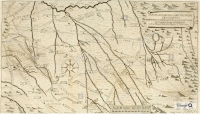
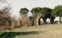
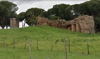
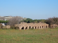
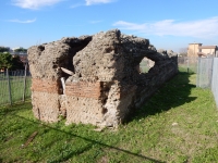
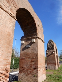
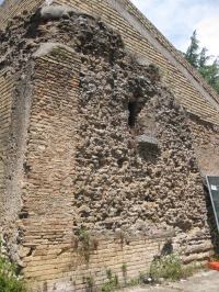
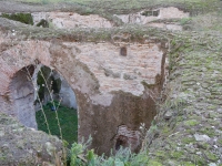
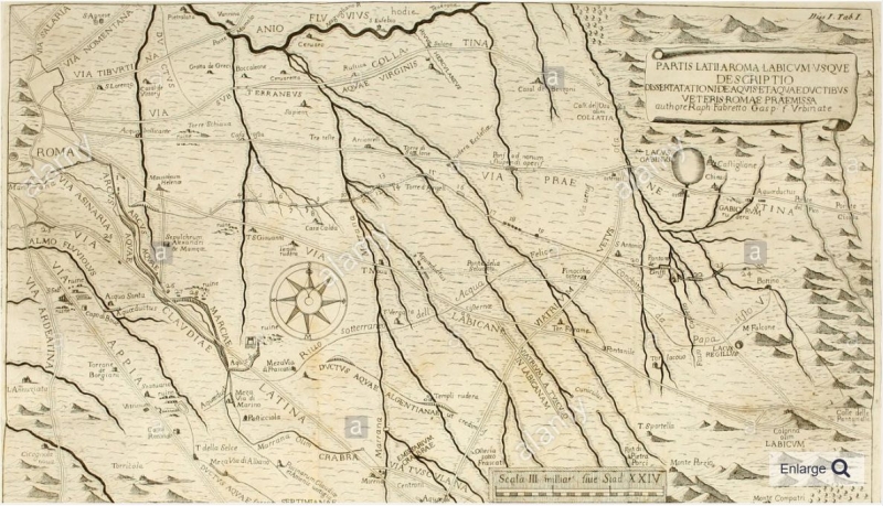
The Aqua Alexandrina aqueduct is circa 22 km long. The source region can be located to the East of Rome at Pantano Borghese, immediately south of the ancient town of Gabii. The aqueduct runs from the very start relatively straight to the city of Rome, between the Via Prenestina and the Via Casilina (the ancient Via Labicana). On its way from east to west it has to cross many south-north running ridges, and valleys formed by tributaries of the Aniene (ancient Anio) river. As a consequence, pieces running above ground, often crossing the valleys on high arches or on double-arched bridges, alternate with those parts conducted underground. Fabretti's map from 1680 shows the path of the Aqua Alexandrina through the described territory very well.

Course of the Aqua Alexandrina

Starting at a height of 65 masl, the aqueduct specus drops already within Pantano to 53 masl, to then continue along the remaining extra-urban distance with a slow decline reaching 46 masl at the last visible point. These measures result in a calculated gradient of not more than 0.0438% for the extra-urban path, and let recognize this aqueduct as one of the lower-level pipelines of ancient Rome.
The Aqua Alexandrina emerges in the later 17th century due to the outstanding work undertaken by Raffaello Fabretti, leading in 1680 to his publication 'De aqvis et aqvaedvctibvs veteris Romae', dissertationes tres. It is most likely that the scholar became aware of the remains, especially in the source area, because of the new construction of the Acqua Felice, even if he assigns the proposal for the naming to his colleague Adrien Auzout. Many descriptions and conclusions by Fabretti are still of great value today.

Extra-urban path

About some 100 m from the probable source in the northeast, the specus outside the GRA emerges from the soil for the first time at Pantano Borghese. It runs then soon on a wall made of concrete containing a great number of stone chips. A line of bipedales is well visible at the bottom level of the specus, while only few isolated traces of a brick facing remain. With the marshy Pantano depression getting deeper, the height of the supporting wall increases and leads to a long line of arches carrying the specus. Regular formed red bricks, sometimes also a combination of red and yellow bricks, were used for the facing. Some traces under the arches' vault still show the impressions of wooden scaffoldings remaining from the construction process. All arches show as a particularity extrados, an outer framing cornice of bricks, running around the single arch-facing made of bipedales. These architectural elements have already been noted, described, and drawn by Fabretti. One may compare the precise descriptions given by Butler and Van Deman for other parts of the same aqueduct.

Subsurface

What follows west of Pantano Borghese is the longest unknown track, mostly due to the fact that here the greater part is running underground.

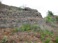
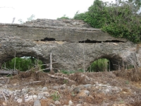
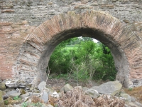
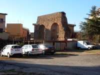
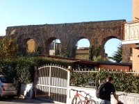
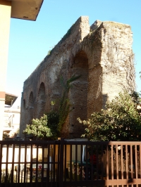
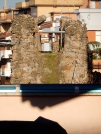
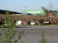
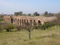
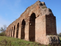
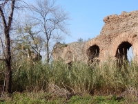
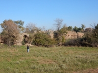
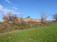
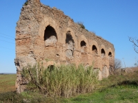
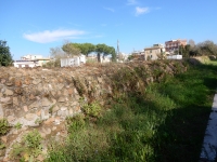
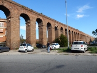
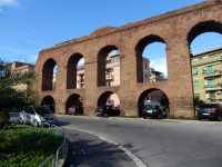
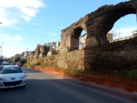
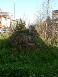
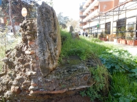
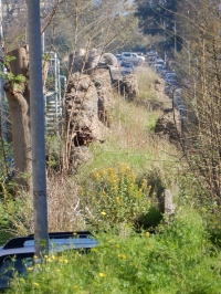
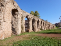
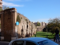
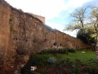
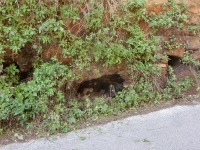
Just before the GRA
East of Via di Torrenova remains of the Alexandrina can be reached on a dirt road located about 200 m south of the intersection of Via Prenestina and Via di Torrenova. This road leads up to an abandoned farmstead and a gravel pit. The best route to these ruins, which are located just below the abandoned farmhouse, in the direction of Via Prenestina, is to leave the dirt road just before the abandoned farmstead and walk down the field to the left onto the valley floor downstream of the arches, which can then be approached from below. There are some substructions on the east bank of the stream that can be more easily reached by following the dirt road around the house and down past the gravel pit (taking the left fork in the road; the other leads south to a working farmstead).
The original arcade here was 28 arches long, of which nine remain, five on the upper bank and four on the lower, separated by a gap of two fallen arches.

From: P.J. Archer (1995): Guide to the aqueducts of Ancient Rome, pag. 111

In [north of] the modern Roman suburb Tor Bella Monaca, between private homes and commercial areas and cut by streets, several groups of aqueduct arches are still preserved. The specus is then again visible, because interrupted by the Autostrada del Grande Raccordo Anulare (GRA), Rome's highway ring.

Within the GRA

Inside the GRA continues the arched construction on the farmland of the Casa della Mistica, reaching for the first time such a great height that double arches had to be inserted, as to be recognized at a heavily overgrown bridge over a brook, and a series of arches near Via Walter Tobagi.

In the valley of Via Tor Tre Teste, a bridge connects from a modern private villa property to the public gardens, where the specus continues to run on low arches and then on ground level. In Via degli Olmi are preserved few tall arches, to let the aqueduct soon again disappear under ground level. This leads to the extensive valley of Centocelle, where the aqueduct crosses today Viale Palmiro Togliatti. As already before with the monumental remains near Via Walter Tobagi, a two-storied bridge reaches here the maximum height of 20.65 m from the ground. Typical for the taller arches are two concentric arches of facing with bipedales; travertine corbels may have been a necessary support during the construction. These spectacular arches were already accurately documented by Fabretti.

In Via dei Pioppi the arches diminish towards the raising ground slowly in height.
Arriving at ground level, the 70 - 75 cm wide specus with thick layers of sinter is accessible and well preserved, before it totally disappears underground. A longer unknown track follows; a tower with various built-in spolia at Via della Primavera, and the next remains after crossing the Via Casilina indicate a straight line for a subterranean aqueduct.

An aqueduct-wall proceeds until arches, getting increasingly higher, continue in Viale dell'Acquedotto Alessandrino. After some left and right turns the aqueduct crosses Via dell'Acqua Bullicante / Via di Tor Pignattara, and finally enters a step in the terrain. The very last visible trace in direction towards the city center is the specus cut by Via degli Angeli.

The unknown urban track

One major problem for research on the Aqua Alexandrina is the lack of evidence for the urban track of the aqueduct, and for its final destination: to the Baths of Alexander Severus, or to the Baths of Caracalla? This final urban track is lost or at least unknown. The modern suburban growth, and lastly decay, have caused the total disappearance of many ruins since Fabretti and Ashby / Van Deman.
After the last visible remains at Via degli Angeli, the aqueduct continues underground in unknown direction. Fabretti drew a sharp turn at this point, to reach ideally Porta Praenestina / Porta Maggiore and from there the Baths of Nero/of Alexander Severus in the Campus Martius. The lack of remains - the part in the garden of the Carthusians is only reported by Fabretti - and the necessary sharp turn to the right as well as the cut specus after Fabretti's turn right, render such a route very doubtful.
Coates-Stephens, more inspired by the confused text sources and the uncertain identification, brought up as an alternative destination a connection to the Baths of Caracalla, thus joining and identifying the Aqua Alexandrina and the Aqua Antoniniana. This solution seems very attractive on the map, allowing for a continuing straight aqueduct line that intersects the other great aqueducts coming from Tivoli, as the Aqua Claudia and the Anio Novus. The levels, as far as known, are not an obstacle, having the last level of the specus of the Aqua Alexandrina (46 masl), at least 4.24 m above the first level of the Antoniniana (41.76 masl).

From: Jens Köhler and David Chacón (see literature below)


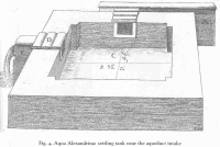
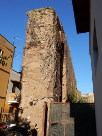
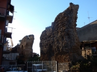
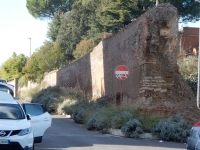
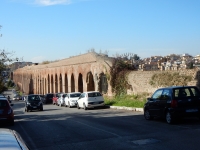
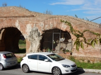
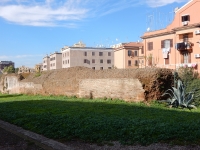
The destination, a summary
The destination of the Aqua Alexandrina waters is still in discussion.
- The 'traditional' view is the Baths of Alexander Serverus, via the Porta Maggiore towards the Campus Martius; for this option is no hard evidence.
- Dr. Coates-Stephens (1998, 176) put forward the idea that, instead, the Baths of Caracalla via the Aqua Antoniniana was the ultimate destination of the AA-waters.
- Quite close to Stazione Termini, in the Via G. Tepe, are the remains of six arches in the style of the Aqua Alexandrina, heading for the Piazza Vittorio Emanuelle II. A third option: the AA joined one of the major aqueducts at the end of the Via degli Angeli, just north of the Banca d'Italia; the water was tapped again (via the Aquae Claudia or Anio Novus) in the area north of the Porta Maggiore to feed - via the arches in the Via G. Pepe - the Nymphaeum Alexandri, also known as the Trophies of Marius at the named Piazza: the terminus of the impressive but low levelled Aqua Alexandrina aqueduct.
Height levels of the specus in meters asl (Tedeschi Grisanti 1992 fig. 3): Aquae Claudia and Anio Novus (at Porta Maggiore) over 65 m; arches along the Via G. Pepe / Via Turati: 62.83 m; supply at the Nymphaeum Alexandri: 62,27 m.

New and even more detailed height measurements and analysis of the calcareous deposits / sinter will have to prove what was the supply of the Nymphaeum Alexandri and what the destination of the Aqua Alexandrina waters.

Wilke D. Schram


Rome - ROMA AQUA ALEXANDRINA - LATIN

Item Info
Length 22 km
Cross-section 0.7 m - 1.0 m
Volume Unknown
Gradient 0.044 %
Period Alexander Severus
Features
  • beautiful arcades
  • destination unknown


Recommended literature :
  • R. Fabretti (1680) / H.B. Evans (2002): De aquis et aquaeductibus veteris Romae / Aqueduct hunting in the seventeenth century (Fabretti's text and Commentaries of Evans, both in English)
  • H.C. Butler (1901): The aqueduct of Minturnae (in: AJA Vol 5 (1901) pag 175 - 199)
  • Th. Ashby (1935): The aqueducts of ancient Rome
  • G. Tedeschi Grisanti (1977): I "Trofei di Mario", il ninfeo dell'Acqua Giulia sull'esquilino
  • P.J. Aicher (1995): Guide to the aqueducts of ancient Rome
  • R. Coates-Stephens (1998): The walls and aqueducts of Rome in the early Middle Ages (in: JRS vol 88 (1998) pag 166 - 178 - esp. 176)
  • J. Kohler and D. Chacon (2017): Aqua Alexandrina: new research (in: G. Wiplinger and W. Letzner (eds.) Wasserwesen zur Zeit des Frontinus, 40 Jahre Frontinus Gesellschaft, Schriften der Frontinus Gesellschaft 4 / BaBesch Supplement 32 - pag. 167 - 177)
Recommended websites   :
How to visit                  : see above

HOME More literature on more aqueducts Last modified: August, 2019 - (webmaster)


Fabretti's map

Settling basin

Pantano Borghese

Ancient improvements

Single band of bricks (1)

Single band of bricks (2)

Crossing Fosso Bella Monaca

Remains on top of a tunnel

'Arcacci'

From Via Magli

After 1800 years

Via Squinzano

Specus of the Aqua Alexandrina

Filled arches

The AA in Tor Angela

AA's cross-section

Close to the GRA

Three sections

repairs on the AA

Conservation work

Fosso Tor Tre Teste

Casale della Mistica

Along the farm land

Six impressive arches

On private property

Ancient and modern towers

Parco Giovanni Palatucci

Water reservoir

In urban Rome

Continuation

Via degli Olmi

Viale Palmiro Toglatti

A small chapel under an arch

Some double arches

Western part

Strange repairs

Cross-section

Calcareous deposits

Near the Piazza di San Felice

Spolia

Viale dell'AA

Arches without cover

Firm 'cross-section'

AA in a Green Area

Double set of arches

Last visible remains

Baths of St. Helena