Aqua Appia

Roman aqueducts: Rome Aqua Appia (Italy) Rome - ROMA Aqua Appia
For the photo's, see below
Home / the complete website

Frontinus tells us about the Aqua Appia that:
'For four hundred and forty-one years from the foundation of the City, the Romans were satisfied with the use of such waters as they drew from the Tiber, from wells, from springs.'
By the late fourth century, about thirty years after the beginning of the Samnite War (343 BC), this supply was to prove inadequate to meet the city's growing commercial and private sectors )1. Another reason may have been reduction in the quality of well water. As Hodge points out (2002:71), most of the Roman well water would have been water from the Tiber that had percolated through. With the increased use of the Tiber, and probably consequent increase in pollution, the quality of well water may have decreased. However, this is not likely, as the ground would have provided an adequate filter.
Initiative
In response to the probable growing need for water, the censor Appius Claudius Caecus built the Aqua Appia in 312 BC. It was the procedure in Rome to entrust to the two 'censors' during their eighteen months of office the building of public works. The 'censor' Gaius Plautius was entrusted with the task of finding a new water supply, which he did. To Appius Claudius was given the responsibility of building the aqueduct, as he was already busy with the Appian Way. The aqueduct had not been completed by the time the 'censors' were to leave office. Plautius stepped down, but Appius Claudius argued that the 'Lex Aemilia' did not apply to him, and remained in office until the aqueduct was built and, as per custom, named after him.
Source
The Appia's source was approximately 24 meters above sea level (20 metres below ground level), at a series of springs discovered by Gaius Plautius Venox. The cognomen 'Venox' was acquired due to this feat. There is no consensus as to the exact location of the source, as the springs were located 16 m. below ground level and have probably been covered over again (Aicher, 1995:34). The intake is described by Frontinus as being 780 paces to the left of the Via Praenestina between the seventh and eighth miles, at a place called Ager Lucullanus. Middleton (1892:336) believes this to be a mistake, and that the probable intake is the reservoirs formed in the ancient quarries, now called 'latomie della Rustica'. The location of the sources is unknown today. See Map D.3 for a guide to the paths that the aqueducts probably took to reach Rome, and Map D.4 for a guide to the paths that they took within Rome.
Course
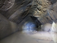
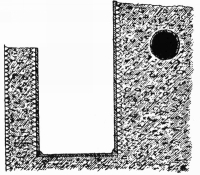
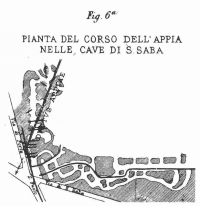
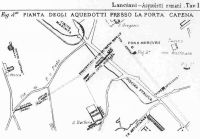
Aqua Appia at Porta Maggiore
It entered Rome underground )2 in the area of Spes Vetus, crossed both the Caelian and Aventine Hills and terminated at the Clivus Publicius in the southern 'Forum Boarium')3, in the Porta Trigemina )4, near the Salinae. )5 . In level it was the lowest of all the aqueducts (Ashby, 1965:21). Compared to later lines the design of the Appia was very basic; for it had no piscina and travelled almost completely underground for its sixteen kilometre length, excepting for its terminus and at an arcade )6 bridging the valley between the Caelian and Aventine Hills near the eastern end of the Circus Maximus. This arcade stood just inside the Servian Wall and no longer exists. From this point the channel continued underground again, probably following the ridge taken by later lines and paralleled by the 'Arcus Caelimontani' of the Aqua Claudia, traversing the Aventine to end near the Tiber. Frontinus notes that the Appia did emerge from its subterranean course at the Porta Capena, however, he continues to point out that there was no 'castellum' installed at this point. Because of its low level, the aqueduct can be traced mainly from the evidence of Frontinus (Evans, 1997:65). The water system pursues this subterranean course probably for reasons of security. Rome was burdened by frequent battles with the Samnites who could have, in an attempt to siege the city, cut the water supply in an attempt to paralyse Rome. Indeed, this is just what happened during the Goth invasions of the early 6th century. According to Aicher (1995:35) the Appia had more in common with early drainage systems than with later aqueducts. Drainage tunnels had long been dug by the Etruscans in the fields north of Rome. Etruscan kings had begun the drainage system of Rome with the Cloaca Maxima. The Appia lacked any 'piscina', in contrast to the later aqueducts.)7 Nonetheless, the Appia was probably considered a marvel at the time of its construction (Evans, 1997:65).
Repairs
Despite their reputation as marvels of engineering, the aqueducts leaked quite badly and required frequent maintenance. Besides information attesting to this in Frontinus, Juvenal and Martial mention the leaks in the Aqua Marcia as it passed over the Porta Capena. The Appia was repaired by Q. Marcius Rex between 144 and 140 BC (Pliny, 36.121) and again by Agrippa (Frontinus, 1.9) and lastly by Augustus in 22-4 BC. Augustus also added a new feeder branch, the 'Appia Augusta', of 6,380 'passus. This drew water from springs located between the Via Prenestina and the Via Collatina. This would be closer to Rome than the original branch and joined the Appian channel near a location Frontinus calls 'ad Gemellos', which is probably at the 'Porta Praenestina'. This introduces an inconsistency; an entire new aqueduct is considered only a feeder, while aqueducts like the mixed Tepula and Julia maintain their identities. Platner & Ashby (1965) curiously do not mention Agrippa's repairs. Frontinus states that in year 719 Agrippa
... repaired the conduits of Appia, Old Anio and Marcia, which had almost worn out, and with unique forethought provided the City with a large number of fountains.
The traditional founding of Rome is 753, so presumably Frontinus refers to about 34 BC, which accords well with Richardson and other scholars' dates. There can be little doubt that repairs were carried out by Agrippa, and Platner & Ashby's omission must be in error.
Gradient and low level
It is problematic to argue that the Appia's main purpose was to supply surrounding inhabitants with water as, over a course of 11,190 passus (16.2 km), the Appia's elevation fell to about 15 meters. This decline, 9 meters or 0,05%, reflects the minimum 'drop off' prescribed by Vitruvius. Therefore the line posed several problems for its contemporary engineers, and their task to provide water to higher elevations, especially residential areas. In fact, as Evans (1997:66) states, that from a technical standpoint the Appia's low level prevented distribution to higher areas.
Aqua Appia's role
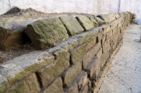
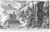
Aqua Appia near the Aventine
(J.B. Piranesi)
It seems probable, however, that the key reason for the Appia's introduction was the increasing commercial importance of the 'Forum Boarium'. While the northern 'Forum Boarium' had the spring of Lupercal, the southern end had no such supply. The positioning of the aqueduct's terminus and the growing number of cults lend support to this theory. Cults such as, Portunus, Fortuna, Hercules, Diana, Mater Matuta Ceres and Liber played a quintessential ?XX role in the marketplace of the Boarium, and therefore, it seems likely that the aqueduct was instituted to meet the increasing need for water that could not be supplied by existing cisterns. Frontinus agrees with this theory. By his time the Appia had been reworked three times. He states that the Appia served seven of the fourteen Augustan regions: the Caelian, Roman Forum, Circus Flaminius, Circus Maximus, Piscina Publica, Aventine, and Transtiber. Frontinus believes that roughly one fourth of the Appia's water was distributed to private inhabitants. This seems very plausible given the date of the aqueduct's introduction, its low level and small rate of declination. Frontinus' figures illustrate that the Appia delivered 70% of its volume to imperial and public buildings. This adds more evidence to the contention that the Appia was instituted for civic as opposed to private needs and perhaps aided the commercial growth of the Boarium and its cults. Over time, as Rome's requirements grew, more uses were found for the Appia's waters.

===================

)1 Compare this to the Croton Aqueduct, which was a large and complex water distribution system constructed for New York City between 1837 and 1842. It was named after its source, the Croton River. The island of Manhattan, surrounded by brackish rivers, had a limited supply of fresh water which dwindled as the city grew rapidly after the American Revolutionary War. Before the aqueduct was constructed, residents of New York obtained water from cisterns, wells, natural springs, and other bodies of water n a manner similar to that of the Romans. But rapid population growth in the Nineteenth Century and encroachment on these areas as Manhattan moved further North of Wall Street led to the pollution of many local fresh water sources. The Old Croton is considered one of the engineering achievements of the 19th century. The tunnel is an elliptical tube 8.5 feet high by 7.5 feet wide. It is brick-lined and uses hydraulic cement for most of its length. The outer walls are of hammered stone. The tunnel is gravity fed for its entire length, dropping gently 13 inches per mile. To maintain this steady gradient through a varied terrain, its builders had to cut the conduit into hillsides, set it level on the ground, tunnel through rock, and carry it over valleys and streams on massive stone and earth embankments and across arched bridges. Typically, it is partly buried, with a tell-tale mound encasing it. The Old Croton was used until 1955, even though it had been replaced by the New Croton, build between 1885 and 1890. See Koeppel (2001).

)2 See Figure D.13 for a photograph of a model showing the Appia, Anio Vetus, Julia, Tepula and Marcia entering Rome.

)3 While the northern 'Forum Boarium' was well supplied with water, the southern 'Forum Boarium' had only one spring that we know of, the 'Fons Scaurianus'.

)4 The Porta Trigemina was an important gate, mentioned often in the ancient sources, but its location is a matter of dispute. It was on the Servian wall between the Aventine and the Tiber, in Region XI (Platner & Ashby, 1965:418)

)5 Aicher (1995:35) speculates that this was probably the site of an ancient salt flat. Evans (1997:68) believes it was the site where salt was either stored or refined. Platner & Ashby (1965:462) are in agreement with Evans, stating that the Salinae contained warehouses to store salt brought up the Tiber. Richardson (1992:341) states that the location would not have been convenient for warehouses, and that the name suggests a place where salt is refined. Evans goes further to speculate that if salt refining took place as late as 312, then a large supply of water would be needed. He states this is unlikely and is in agreement with Aicher, Platner & Ashby and Richardson that by 312 nothing but the name remained.

)6 If this arcade dated from the original construction of the Appia, then it one of the very earliest, if not the earliest, use of an arcade in Roman architecture (Evans, 1997:67).

)7 Torelli, in Rosenstein & Morstein-Marx (2006:93), states that it did have a 'piscina publica'.


From E.J. Dembskey: The aqueducts of Ancient Rome" (master thesis 2009)


HOME More literature on more aqueducts Last modified: January, 2010 - Wilke D. Schram (w.d.schram@romanaqueducts.info)


Channel of the Appia

500m long section

Appia under the Celio

Aqueducts near
Porta Maggiore

Porta Maggiore

Channel op the Appia

Pipes of the Appia

Excavation

Appia near the Palatine

Appia near S. Saba

Near the Porta Capena