Sa Trapa (18th c)
Non-Roman aqueduct: Sa Trapa monastry (Mallorca, Spain)
The water supply of the 18th c Sa Trapa Monastry (Mallorca, Spain)
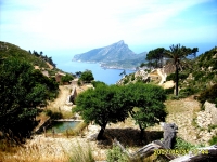
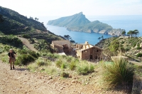
The remains of this 18th century Cistercian monastery are located on the southwest coast of the Spanish island of Mallorca near the town of San Elmo
opposite the island of Dragonera. Today it is an area of 81 ha including the former monastery, and owned by the environmental organisation
GOB. GOB has started renovations and the Sa Trapa's buildings will eventually serve as a 'refugi' for hikers. Its superb location
directly overlooking the Mediterranean from a height of 270m makes it one of Mallorca's favourite hiking destinations.
The order of Trappist monks, a part of the Cistercian order, was founded in 1644 in the La Trappe (Normandy - France). As a result of the French Revolution the order was forced
to leave France and in 1789 initially chose the town of Zaragoza in Spain as its new location, strongly supported by Father Roig (namesake of the full day "Puig Roig" mountain hike?),
later moving on to Mallorca to the lonely location known as the Valley of St Joseph and by 1810 the construction of Sa Trapa was completed.
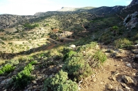
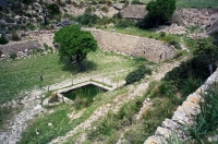
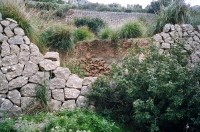
Looking at the size and number of buildings as well as the available arable land, it can only have been a modest community compared to the average size of the monasteries of
Northern- and Central Europe. However next to the church and other buildings, especially the construction of the many terraces required an enormous amount a physical labour.
Furthermore being quite far removed from 'civilisation' and accessible by only one steep mountain road, the logistics must have been daunting.
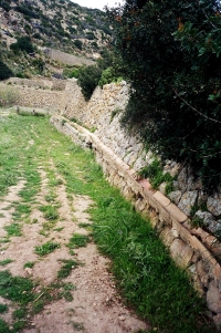
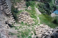
Within this horse shoe shaped valley a large platform contained housing for man and beasts as well as an olive press, a grain mill, and of course a church. Towards the end of the
valley a further number of terraces were constructed up to a height of 400 m. These terraces supplied the food and fodder but they also played a major role in the water supply
as no (perennial) sources are found anywhere in the valley.
However the monastery was rather short lived: after only approximate 14 years it was abandoned. In 1835 Queen Isabella III then decreed the secularisation of all church property
and Trappist's had to leave altogether; they never returned to Mallorca. Although time wise far removed from the 'heydays' of aqueduct construction under the Roman Empire and
on a much more modest scale, the principles of construction as well as the philosophy behind it, bears notable resemblance: a simple system that works over a longer period of time
practically without much need for any supervision nor maintenance.
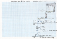
So let us look in the upstream direction, at what is left of the construction today which should be enough to understand how the system worked.
Level 0: the main house
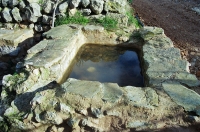
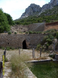
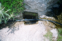
Starting from what is today the final visible destination of the aqueduct: a stone basin which walls were covered with waterproof mortar, in front of the main housing structure
(length 1.76 m and width 1.65 m, with an overflow opening in 260°). Upstream there is no longer a direct connection with the next feature: a small water channel (inside width
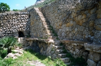
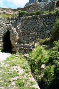
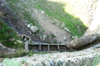
0.2 m) simply made up of turned over round roofing tiles, set onto a low wall. Following this channel upstream we come to a cut stone stairway that leads to the next higher terrace.
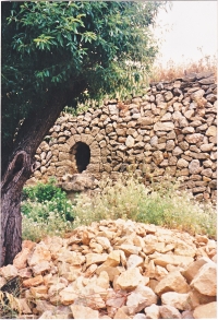
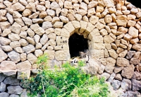
The channel goes over and around this staircase and ends at a small arch, width 0.56 m and height 0.68 m. This arch is set in loose stone without use of cement-mortar. Behind this
arch is a short tunnel, again made up of overturned roof tiles. This tunnel ends underneath a loose stone set vertical open shaft which runs the full height of the terrace to the next
higher terrace where the purpose of this shaft immediately becomes clear.
Tunnel 1, 12 m long
On this next higher level we can see a large main collecting basin (length 4.50 m, width 4.20 m, full depths 2.25 m so appr. 42.5 m3 equivalent to 42.500 litres. This basin has on its
front a semi-circular overflow over which the surplus water falls into the afore mentioned vertical shaft and from there on by means of the small wall channel, to its final destination:
the basin in front of the housing area. When we continue upstream we come, on the right hand side, to the inflow of a small channel into the main collecting basin. In this channel is
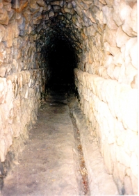
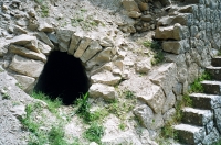
cut out a small settling basin which slows down water speed and force allowing floating impurities to 'settle'. Further upstream we see the origin of this channel, a large tunnel, again
set in loose stone (length ca 12 m, width 1.20 m and height 2.15 m and fully accessible. Entering this tunnel we see below on the right hand wall side a small cut out of an overflow
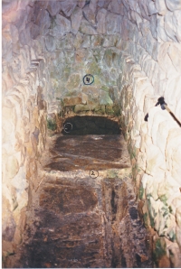
channel (width 0,20 m) which we follow towards the end of the tunnel. Near the end we cross over a large stone slab that marks the beginning of a collecting basin. Over this basin
(length 1.20m, width 1.0 meter and depth 0.5 m, so with a capacity of 0.6 m3 = 600 litres) is set a loose stone shaft structure which really forms the heart of the whole system.
This loose stone set 'shaft' goes up all the way to the next higher platform and is anchored in the above terrace wall. All the rain that falls on this terrace's surface seeps through
the loose stones setting, thereby also being purified and eventually the water drips / flows into the basin at the end of this tunnel.
One could imagine that that was all there was. However when leaving the tunnel one can see on the left hand side a four chamber settling basin with a double outflow into the same
channel leaving the tunnel towards the main large basin. Luckily there are some minor clues left as to its possible purpose. One can see at the upper terrace edge, remains of - again -
turned over round roofing tiles hanging down which although today leading nowhere, indicate that there must be more on the higher next level.
Tunnel 2, 19 m long
By a cut stone stairway further to the left of the tunnel entrance one climbs to the next higher terrace where regretfully the system has been badly damaged. In fact there is here an
identical but longer second tunnel (approx. 19m) which is partly caved in as a result of the terrace wall collapsing onto the tunnel. One can still enter the first part but the collecting basin,
loose stone shaft and the start of the outflow channel are under the debris and no longer visible nor visit able.
It is very instructive, although the stairs were also damaged, to climb up one more terrace were again the next back wall has collapsed but ... thereby showing the beginnings of its loose stone shaft!
Short-cut with basins
The connection between the second tunnels collecting basin and the main channel from the first aqueduct mostly likely was in the form of a covered two roof tile 'pipe' leading from this
second tunnel exit to the scant remains now 'hanging' next to the exit of tunnel 1 and was very likely supposed to deposit its water, for further clearing and cleaning, into the four-chamber
settling basin and then directly into a further two-chamber basin from which water flowed in to the first tunnel's main channel.
This system supplied water to the left side of the valley, the main housing area and the church.
On the same two terraces where the tunnels are located, two small arches can be found in situ but more to the left. Near the first tunnel there is but an arch with no sign of a channel.
Near the second tunnel the arch (height 1.0 m and width 0.6 m ) shows a 0.15 m roof tile channel turning left, likely to supply the right hand side of the valley where the animals were
kept. Here no further traces could be located.
In all this is a self-propelling gravity fed system that worked still, long after Sa Trapa was abandoned, and build by simple means but effective.
That the GOB will also fully restore the aqueduct is most likely wishful thinking but still a visit to Sa Trapa is a very worthwhile experience. For a nice hiking tour, see
the web.
Driek van Opstal
| Recommended literature :
|
|
| Recommended websites :
|
|
| How to visit :
| GPS coordinates of the main building of Sa Trapa: N 39.36.018 - E 002.21.619
|