Split (Croatia)

Roman aqueducts: Split (Croatia) Split - SPALATO
For the photo's, see below
Home / the complete website

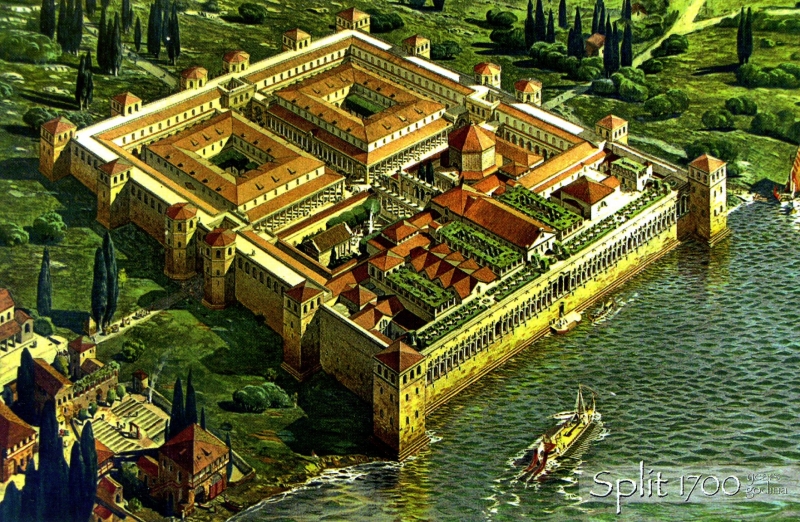
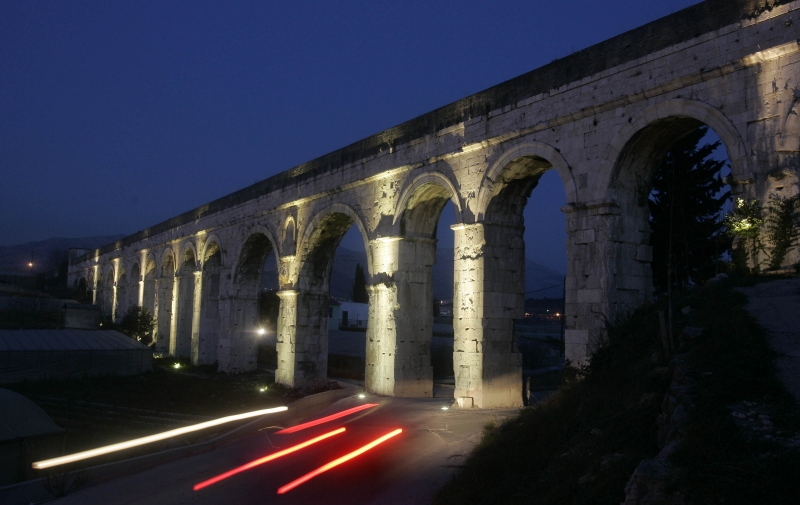
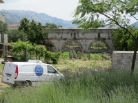
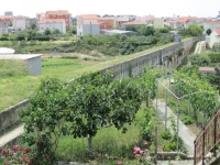
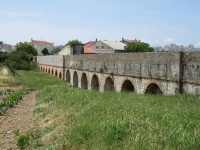
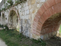
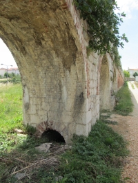
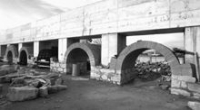
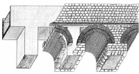
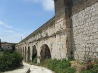
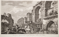
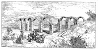
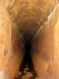
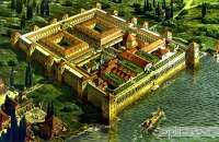
The Roman aqueduct of Spalato (present Spilt, Croatia) was built simultaneously with the Palace of Diocletian (ca 243 - 316 CE) in the late third and/or early fourth century. It was used for the water supply of the imperial residences and weaving workshops within the palace, and probably for the villages in the area.

Artist's impression of the palace of Diocletian in Split (Croatia)


From the source of the Jadro to the Palace the aqueduct was about 9 km long, and as the height difference of both endpoints was 33 meters, the average fall of the channel was 0,37%. The cross-section of the channel was on average 0,75 x 1,60 m, but varied depending on the part of the route. Specifically, the lower parts of the route were over land in a brick construction with pylons and arches, but the main part was partially or completely underground.
Where the aqueduct met solid ground or was put at a greater depth, the channel was wider and higher, while on or near the surface the channel was made of masonry, with a uniform cross-section.

The maximum capacity of the source was estimated 1500 litres of water per second (or 129,600 cubic metres per day), which according to today's standards, could serve a city of 173.000. The Jadro spring is still in use by the city of Split as source for its drinking water.
In the 10th century Constantine Porphyrogenitus, imperial author, stated that the water of Solin "... was the best tasting of all water, as those who have tasted it aver", adding that Diocletian's family was from Solin. During the Middle Ages the arcade of the aqueduct bridge in Dujmovaca was used as a striking topographic landmark: the land of the Split nuns of St Benedict, for example, was described in the 11th century as being located by and above the great arches (super magnos arcus) or below the "ruined arches" (supra minimos arcus).


The Roman aqueduct of Spalato / Split
Its course on several maps

Izvor Jadra = Jadro spring.
Note the area's indicated as Solin, Dujmovac, and Ravne Njive. Bilice is close to Karabac (Belamaric 1999)
Assumed position of the Roman aqueduct course and Castellum Divisorium - as drawn by Marasovic c.s. (2014) (middle and right drawing) - partly coincided with the 19th c upgrade of its successor. Drawing of the route of the aqueduct, part of a specific research program: Ancient Water Systems of Salona and the Diocletian's Palace (2014 - 2017).

Course

The Jadro spring near Solin is still characterised by the even power and quantity of the water it provides, irrespective of the season. The first part of the aqueduct channel entered the actual Jadro Spring at the end of the underground river of Mosor, and then went along the foothills of Mt Mosor, underneath Mravinci, intersecting, at the place known as Prosik, the street called Kunceva greda. Then it goes underground all the way to two valleys (Karabaši and Bilice) south of Solin, where it flows over low arches, and arrives at the Suhi Most (Dry Bridge), in Dujmovaca, where in 1878-79, 28 monumental arches were restored. The aqueduct is here, at the place of the biggest depression or the highest elevation of the aqueduct (the same place where the road passes underneath it) built as a prestigious piece of architecture in the best building techniques, with large, regularly dressed and finally worked stone blocks (opus quadratum), joined with iron clamps. Apart from at Kopilica, where another section on arches can be seen again, the aqueduct goes on from here underground to Lovret, in the city itself.
From the archaeological point of view, the most interesting part is that on Ravne njive (just north of the Ulica Domovinskog rata), where it is incised into the stone as a tunnel, in places up to 21 m deep, heading for the imperial palace of Diocletian.

History

The aqueduct came out of function probably during the Gothic Wars 535 - 555 CE, when it is was damaged which interrupted the water supply to the Palaces for the next thirteen centuries. The restoration and reconstruction of the aqueduct was discussed in the mid-19th century. On May 1, 1855 architect Vicko Andric started excavating and making architectural drawings of the archaeological remains. This date was perhaps deliberately chosen for symbolic reasons, for it marks the 1550th year of Diocletian's abdication (in 305 CE), the day which is most usually taken as the formal conclusion of the building of the Palace.
Of particularly vital importance was Andric's observation that the central capacity of the aqueduct between the source, its subterranean and above-surface parts showed that Diocletian's architect had achieved the least possible length in conjunction with the less possible work on subterranean constructions and arches above the ground - which spoke of exceptionally skilled geometers and engineers.

The Suhi Most (Dry Bridge) by night, a 19th c reconstruction of a Roman aqueduct bridge.


During the final restoration from 1877-1880 - during Austrian rule which lasted from 1815 - 1918 - about 35% of the length of the ancient aqueduct was able to be used without great repair efforts, another 25% needed the vaulting rebuild, and about 40% needed complete repairs.

In 1932 a pump station in Kopilica was added. Since then, the city got her water from a new pipeline and the excess water flowed in the old channel. After the epidemic typhus in 1948 the water from the old part of the route was no longer used for drinking.

Reconstruction

One part of the aqueduct, with 17 arches on pillars near the roundabout, at Bilice just south of Solin, was reconstructed in 1999, while a new road was being built. The reconstruction was executed at a location where in the 19th century the Roman aqueduct was already replaced by a set of 'new' pillars and arches. After thorough archaeological and technical investigations, the Roman remains and the 'Austrian' pillars, arches and channel were removed, a new substruction was built, the aqueduct got a new concrete core, and a new facing of stone and bricks was added.

Wilke Schram,
based on local visits and different internet sources


Time table Salona and Spalato (Split)
3 -1 c BCE Delmat settlements in Salona's core; Greek colonization
2 - 1 c Conflicts between Rome and Delmats
117-9 Roman general Metellus Macedonicus invaded Salona
48/47 Julius Caesar makes Urbs vetus of Salona into Colonia Martia Iulia Salona
27 Octavian defeats Delmats
Salona becomes capital of the Roman province of Dalmatia
Augustan Construction of the Aqueduct of Salona
1st c CE Construction of the Forum, theater etc in Salona
100 Urbs Novus
Late 2nd c Refortification of Salona
Late 3rd c Flourishing Salona; residence of Diocletian in Spalato
Early 4th c Construction of the Aqueduct of Spalato (Split), Christianity
6th c Croats; christianity flourishes; Episcopal center
614 Salona abandoned because of Slav invasions


Split - SPALATO

Item Info
Length 9 km
Cross-section 0,75 m x 1,60 m
Volume ?? m3/day
Gradient 0,37 %
Period Early 4th c CE
Features
  • reconstruction in 19th c
  • "Suhi Most"


Recommended literature :
Recommended websites   :
How to visit                  : see above

HOME More literature on more aqueducts Last modified: October, 2013 - (webmaster)


Source of the Jadro

Austrian aqueduct

Austrian reconstruction

Roman arcade ??

After (re)construction

Aerial view on Bilice

Find the differences

Details

Detail of a pillar

Concrete core

Refacing

Austrian aqueduct

Stone types

Suhi Most

Ponte Seche

Vedute

Ancient remains

Cross-section

Continuation 1

Continuation 2

Tunnel under Ravne Njive

Brodarice

Watertight plaster

Roman channel

Inside the channel

Water reservoir

Medallion

Present office

Modern aqueduct

Probes

Diocletian's Palace