Tarragona (Spain)
Roman aqueducts: Tarragona (Spain)
Tarragona - TARRACO
Tarraco (Tarragona) had at least two aqueducts, one with its source in the Rio Gayá, NE of the city, and the other with its
source in the Rio Francolí, to the north. A third aqueduct may have carried water to the port area, but is only cited by a
source in the 16th century and further poorly known.
Water was needed not only for the city, the capital of Hispania Tarraconensis, but also for the numerous ships that visited
the harbour. The Gayá and Francolí aqueducts served the higher parts of the city with its monumental provincial forum,
which lies on a hill to the east of the port area.
The Gayá aqueduct had its water intake point probably close to Pont d'Armentera in the Gayá river northeast of Tarraco,
and in that case was the longest roman aqueduct of Tarraco (Pont d'Armentera lies 7 km east of exit 10 on the motorway A2
from Barcelona to Lleida). It is mostly underground and lacks spectacular features. It was renovated in the 18th century
by Joan Antonio Rovira on orders of Archbishop Santiyán and was repaired many times since then. As a result, most traces
of the roman channel have been destroyed, but some remains can be seen close to the ruins of the 18th century aqueduct
along the Calle Rovira i Virgili and also along the road that leads to Pont d'Armentera.
Legend
The master builder was building the bridge and a gust of wind blew it away. In despair he said that only the devil
could build a bridge that would last a thousand years. So the devil appeared to him and ensured him that he would build a bridge that very night.
In exchange the devil demanded the soul of the first to drink the water that went across the bridge. The first to do this was an ass (donkey)
whose soul the devil kept.
From the information panel along the highway, made by Abertis Autopistas.
|
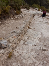
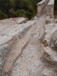
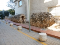
The Francolí aqueduct has minor remains along most of its length. In Tarragona, remains can be seen near the
"Fuente de los Cuatro Algarrobos", north of the city, abouts 250 metres east of the N 240, in the Camino del Ángel at the
junction with Avenida de Catalunya, and at the outer wall or Falsa Braga, where it apparently divides into sections that
feeds the upper and lower city respectively. North of Tarragona, there are also remains in El Mas Blanquet,
and in the del Castellot brook, 250 m upstream of the Pont del Tupino. The difference in altitude measured for
these remains 1080 m apart is 4,4 m which gives a gradient of 0,4% . The source in the Rio Francoli was probably
opposite the village of El Rourell at an altitude of 92 metres.

|
Technicalities
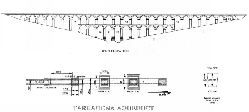
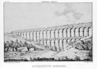
The bridge measures 217 meters and has a maximum height of 27 meters, not counting the water gallery, now destroyed.
It consists of two levels of superimposed arches, with 11 arches on the lower level and 25 on the upper level. The arches have a width (span)
of 6,30 meters, a height of 5,7 meters (where they do not have to adapt to the incline of the ravine) and a width of 1,86 meters.
The distance between the arches is 8 meters. The elevation of the bridge on the north side is 56,8 meters and 56,4 meters on the south side
[which gave a fall of 0,4 meters and a gradient over the bridge of 0,2 %].
From the information panel along the highway, made by Abertis Autopistas.
Drawing from Leather 2002.
|
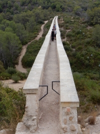
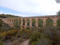
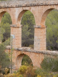
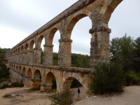
The most spectacular feature of the Francolí aqueduct is the aqueduct bridge of Ferreras, also known as the Puente del Diablo
(devil's bridge) with a maximum height of 26 m and a length of 249 m, including the ends where the specus runs on a wall.
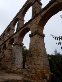
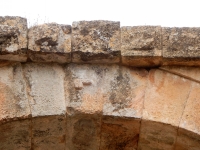
It consists of two tiers of arches, all with the same diameter of 20 Roman feet (5,9m) with a variation of 15 cm.
The distance between centres of the pillars is 26 Roman feet (7,95m). The present width of the specus is 2,5 roman feet,
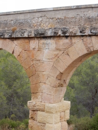
but this may have been modified by restorations in the course of time. A special feature of this aqueduct bridge is the
stepped nature of the piers below the imposts of the arches. Each step increase the width of the pier by half a roman
foot (15 cm), almost certainly to increase stability. Similar stepped piers are known for the aqueduct of Metz in France.
The bridge probably dates from the time of Augustus. There is a small quarry 100 m North of the bridge which may have
provided the building stone.
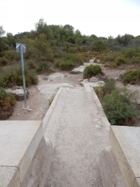
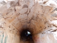
The Ferreras aqueduct bridge can be easily reached from the N 240, but also from a parking on the A7 motorway
(only for travellers coming from the direction of Barcelona!). From the parking, it is possible to walk in the
specus over the aqueduct, and also to reach the valley below.
The supposed Suburbio aqueduct can not be related to any other known water supply structure of Tarragona.
However, it can be assumed that it was built after the aqueduct of the Francoli.
The aqueduct would have had its inlet in the Francoli river, in the area of Sant Pere Sescelades, downstream of the
inlet of the Francoli aqueduct. The only known remains are within the city, at a level too low to be related to any of
the other two aqueducts.
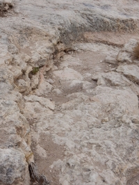
It has been proposed that the route followed that of Rec Major, a canal of medieval times built to power water mills
in the southern part of the city. The remains enclose a specus 0,60 m wide and between 1.5 and 2 m high, built in
opus caementicium. The only preserved section of this supposed channel is in the street Doctor Mallafré, where
a 12 m long part has been conserved.
Cees W. Passchier
Tarragona - TARRACO (Francoli aqueduct)
| Item
| Info
|
| Length |
15 km |
| Cross-section |
width 0,74 m (2,5 roman feet) |
| Volume |
Unknown |
| Gradient |
central part of the bridge 0,2 %
overall 0,4% |
| Period |
Augustan |
| Features |
- major bridge
- minor remains of other bridges
- channel, see main text
|
|

|
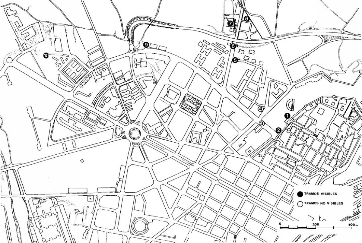
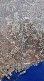
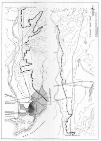
Outdated map of Tarragona (f.i. the highway A7 is missing).
From: SanchezReal (1994).
|
|
Local remains
| Gaya acieducto (45 km North-East) |
see map |
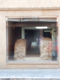
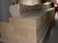
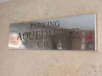
| Carrer Rovira I Virgili nrs 45, 46, 58 [# 5 in Carrer fra Antoni Cardona i Grau] |
5 - 7 |
| Carrer de San Auguri |
8 |
| Via del Imperio Romano nrs 11 and 21 / Via de l'imperi Roma |
12 |
| Francoli acueducto (15 km North) incl. the Puente del Diablo |
|
| Camino del Angel / Cami Angel (not visible) |
11
(E of 9) |
| Avenida de Catalynya nr 43 - 47 (in the Camide l'Oliva) |
9 |
| Suburbio acueducto (to the harbour to supply ships) |
|
Carrer Macia Mallol i Bosch, near the corner with the Carrer Mallafre Guasch |
10 |
| Extra (Placa del Pallol / Passeig Arqueologico, city center) |
|
| Between tower and theater |
1 |
| Murallas Paseo Arqueologico |
2 |
|
| Recommended literature :
|
- G.M. Leather (2002): Roman aqueducts in Iberia pag 50 - 54
- F. Sáenz Ridruejo (1977): Observaciones tècnicas sobre el abastecimiento romano de aguas a Tarragona (in: Segovia: symposium de la archaeologia romana 1974 (1977) pag 351 - 358)
- E. Sanchez Lopez and J. Martinez Jomenez (2016): Los acueductos de Hispania, construction y abando (on the web)
- J. Sanchez Real a.o. (1994): Datos para el estudio de los acueductos romanos de Tarragona (in: Quaderns d'Historia Tarraconense vol 13 (1994) pag 106 - 115)
|
| Recommended website :
| None in particular.
|
| How to visit :
| See descriptions above and below.
|