Toledo (Spain)
Roman aqueducts
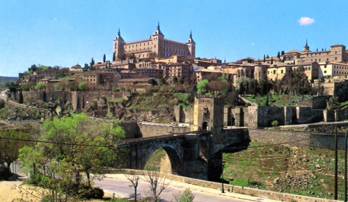
Toledo - TOLETUM
| For the photo′s, see below |
The city of Toledo became part of the Roman empire in 192 bc. The Roman conquest was a long lasting affair, beginning in 206 bc with the capture of Carthagian possessions
in the south and ending with the crushing of the last resistance in the north west in 19 bc. By this time a network of roads connected towns and cities, crossing major rivers.
Several Iberian cities including Emerita Augusta, Corduba, Hispalis, Carthago Nova and Toletum were substantial places. The Iberian peninsula was one of the most prosperous
regions of the Roman empire, not only famous because of its wine, olive oil and garum (Roman fish sauce) but also its metals: gold in the north west and copper and silver
in the south west. Toledo, backed by military settlements as from the Republican period, enjoyed the development of a large city and in the Imperial era it had some large public works
like a bath building and two aqueducts.
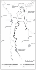
Until recently Spanish scholars were of the opinion that ancient Toledo was equipped with only one aqueduct with the Alcantarilla dam as the main source. The recent study of
M. Arenillas Parra, M. Barahona Oviedo, and others shows that we have to take into account three water systems:
- the aqueduct along the arroya de La Pozuela
- the aqueduct along the arroya de La Rosa with its own water sources
- the extension of the La Rosa aqueduct, which had its source at the presa (dam) of La Alcantarilla, in the Rio Guajaraz
There are no conclusive data allowing precisely dating any of the three water supply systems but major parts are constructed in the first and second century AD.
The differences in capacity between the three systems is striking:
- La Pozuela: 260 m3/d
- La Rosa: 2.160 m3/d
- La Alcantarilla: 8.640 m3/d
Source: arenillas2009
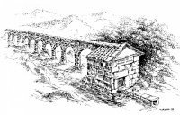
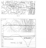
Most parts of the main channel, the 38 km long aqueduct which took its water from the now called Alcantarilla dam that blocked the Guajaraz river, were built as a free channel, covered with a vault.
In the vicinity of the city the water had to cross the Tagus river some 75-100 m below. Present insights suggest the use of a siphon starting from the Cerro Cortado at
an elevation of 550m a.s.l. so the aqueduct bridge - some remains are found 40m above the Tagus - acted as a venter bridge. From this level the pipe(s) rose up to
an elevation of 548 m a.s.l. on the opposite bank. It is assumed that the so-called ′La cueva de Hercules′ some 250 m to the west, served as a storage and distribution center.
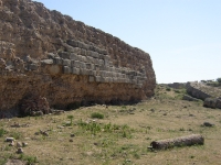
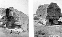
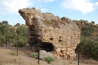
The Alcantarilla dam
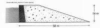
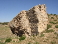
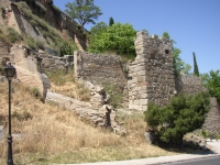
The dam is located on the river Guajaraz, a tributary of the Tagus river, and was built as a large earth embankment with a retaining wall of which traces are preserved
almost in tact and various blocks strewn over the ground. The maximum length was over 800 m, the maximum height between 15 and 20 m. The retaining wall
- some 4 m wide - was formed by a lime concrete core (opus caementicium) of about 0,60 m wide. This core is situated between two masonry wall sections (opus incertum)
of variable thickness (0,90 - 1,50 m). The upstream wall section was wholly composed of ashlar courses (opus quadratum).
As we know today, such a composition is not very stable. Due to the pressure of a (saturated) embankment, in combination with a low water lever in the lake,
the dam was breached, presumably in Roman times. Note that it was broken at the waterside of the dam.
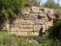
There are remains of two towers at the Alcantarilla dam, both measuring 3,55 x 3,55 m internally (12 Roman feet); the walls were 0,64 - 1,05 m wide
(about 3 Roman feet). These two were attached to the retaining wall downstream. One of them must have functioned as a water intake tower, the other as an overflow. The remains of the dam
are situated in the backyard of the hacienda ′Alcantarilla′. The middle part is almost in tact, at present the eastern part is also in use as a supporting wall for the
main buildings of the hacienda and some stables. In between these two parts is the still flowing rivulet Guajaraz and a confusing collection of major pieces of
stone blocks among which the remains of the broken wall, and parts of the two water towers.
Between Alcantarilla and Toledo
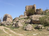
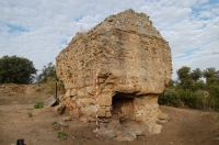
As described by C. Fernandez Casado (1992 / 2006 pag 211 - 213) some scarce remains of the ancient aqueduct channel are still preseved between the dam and the
south bank of the river Tagus. The most interesting part, 2 km before the river crossing, is the Torre del Horno del Vidrio, a small building (4,60 x 3,50 m) designated
to enable the water to lose height. A vertical, cylindrical shaft of 0,52 m in diameter joined the two basins with a height difference of 3,70 m. The water entered at the
upper lever on an arcade, leaving the building by a lower level channel toward the river Tagus.
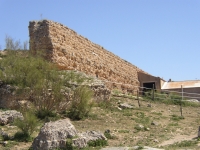
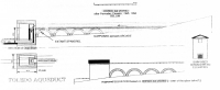
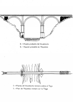
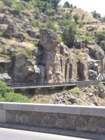
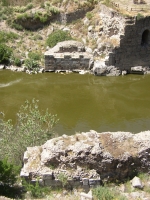
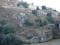
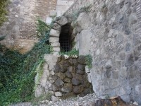
The river crossing
The most visible remains of the aqueduct near Toledo are the abutments on both river banks, and two stubs of the bridge foundations which correspondent with three
spans of 28 m in diameter and 5 m wide. To cross the river on the required height - about 80 m above the river Tagus - one or more extra tiers were necessary resulting
in an aqueduct bridge much higher than the Pont du Gard and also much vulnerable. So, according to the present insights, a siphon was used crossing the riverbed on a
height of 40 m, based on a one-tier venter bridge. To reach this level the length of the piers had to be 26 m.
The water came from a level of 550 m a.s.l., made a drop of about 40 m in one or more pipes, presumably of lead, passed the bridge 40 m above the Tagus river and
ascended on the other bank to a level of about 548 m.
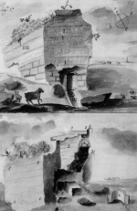
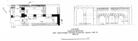
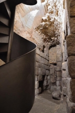
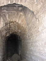
La Cueva de Hércules
After the river crossing the remains of only some parts of the siphon bridge of the La Rosa aqueduct are visible. About 250 m to the west, in the hart
of the city of Toledo, remains were found presumably belonging to a water storage and distribution site. This location, under an ancient church in the Callejon de
San Ginès, is locally known as La cueva de Hercules, the Hercules cave. This cave has a rich history and several legends are attached to it. In 1546, based on
a request of its cardinal, Francisco de Rojas did already some ′research′ reporting parts of some bronze statues. Others were of the opinion that this site was a
temple dedicated to Hercules. In ancient times, as was told, a young boy took refuge in the church for his master and, after a travel, found himself back on one
of the river Tagus banks.
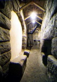
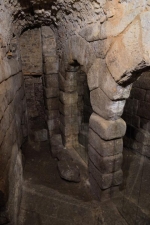
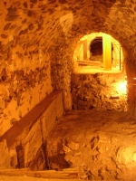
The cave comprised of at least two parallel chambers covered by a vault 11,8 m long and 2,85 m wide for one chamber, the other with an internal span of 2,65 m,
with intercommunicating arches with openings of 2,20 m span. Recently (until 2011) new excavations have takeb place, under the leadership of prof. dr. Vasilis Tsiolis
(UCLM) that might throw new light on this ancient ′cave′.
Other water related structures
Due to the cities archaeological department, now called the Consocio de Toledo, several interesting historical remains from the past are now presented to the public
among which the Roman Baths at the Plaza de Amador de los Rios - including a fine part of the water channel within the town - and the Roman vaults at the Calle
Nuncio Viejo nr. 19.
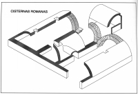
Not less interesting are the Roman cisterns under the Delegacion de Hacienda de Toledo (the local tax office): three interconnected rooms, each 5,75 m (20 Roman feet)
and 3,20 m , 1,95 m and 3,20 m wide while the middle one gave access to a fourth room of 2,90 x 2,40 m (10 x 9 feet). Although very nearby, the connection from
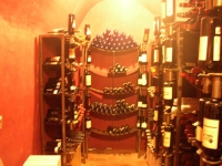
these cisterns to the known water channel crossing the Calle Alfonso X el Sablo, has not been discovered yet. A cross-section of this channel can be visited in the
wine cellar of the restaurant Kumera in the same street.
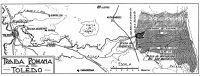
How to reach
The remains of the Alcantarilla dam are located on private property. It is situated a few kilometers south of the road from Mazarambroz to Cuerva (CM 410). Leaving
Mazarambroz turn left at an oblique angle and take, after a few hundred maters, the dirt road at your right hand. Follow this rough road for about three kilometers partly
along and partly between fences until the Alcantarilla farm, 150 m at your right hand. Ask the proprietor for access and close all gates behind you.
Coordinates: N 39° 39′ 45″ W 4° 03′ 27,5″
The abutments and foundations of the siphon bridge can be found along the river Tagus banks, 200 m south of the Puente Nuovo. There is a nice view from the
Paseo de Cabestreros where it meets the Calle Cervantes.
Coordinates: N 39° 51′ 35,4″ W 4° 01′ 06,7″
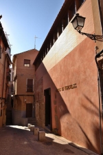
The Cueva de Hercules is not (yet) open to the public. It can be found in a church like building in the Callegon de San Ginès.
Coordinates: N 39° 51′ 31″ W 4° 01′ 28″
Wilke Schram
Toledo - TOLETUM
| Item
| Info
|
| Length |
km |
| Cross-section |
m x m |
| Volume |
m3/day |
| Fall |
% |
| Period |
Augustan |
| Features |
- Dam with water towers (Alcantarilla)
- Dropshaft (Horno del Vidrio)
- Aquaduct bridge, probably with siphon
- Distribution site: La Cueva de Hercules
|
| Recommended literature :
|
- M. Arenillas Parra, M. Barahona Oviedo, and others: El Abastecimiento de Agua a Toledo en Epoca Romana (2009)
- C. Fernandez Casado: Acueducto Romano en Espana (1972,reprint in 2008)
- J. Garcia-Diego: La Cueva de Hercules (in: Revista de Obras Publicas vol 3114 (1974) pag 683 - 700)(in Spanish)
- F. Aranda Alonso, J. Carrobles Santos and J.L.I. Isabel Danchez: El sistema hidraulico romana de abesticimiento a Toledo (1977)
- G.M. Leather: Roman aqueducts in Iberia (2002)
|
| Recommended websites :
|
|
| How to visit :
| see above
|