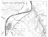
In short: by Waldrach the Roman aqueduct took water from the Ruwer river - a tributary of the Mosel river - which was conducted in an almost 13 km long channel and partly
over some small aqueduct bridges, to the city of Trier. Its gradient was 0,06%.
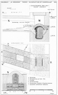
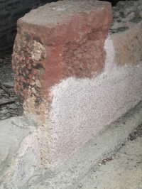
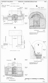
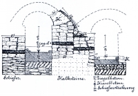
The arched, masonry channel was made of crushed stones with walls of 0,96 - 1,30m high and 0,74 - 0,78m (2,5 Roman feet) wide. It was plastered
with a watertight lime mortar (opus signinum). Its maximum capacity was about 25.000 m3/d.
Via a distribution basin (castellum divisorium) at an yet unknown location in Trier, the water was brought to the main users: via street fountains
to the general public and to the visitors of the Roman bath houses in the city.
Also of interest in Trier (Germany):
- Roman bridge, Roman amphitheatre, Palast Aula (Basilica), Porta Nigra (Roman gate)
- Barbara thermen (Barbara baths), Viehmarkt thermen (Forum baths), Kaiser thermen (Imperial baths)
|
During the pre-Roman period, drinking water came from local wells and some small rivers in the area for example in the area of the so-called Herrenbrunnchen.
Before the 2nd c CE when the Ruwer aqueduct was built, there were already other small aqueducts for example in the Temple quarter: the water flew in a
subterranean channel and on top of a series of 17 arches. Also a series of wood pipes have been found (Samesreuther 1936 pag 114/5).
Population growth, building project in the 2nd century CE and in particular the new built Barbara baths, put more and more pressure on the water demand resulting
in the construction of the Ruwer aqueduct.
The aqueduct proper
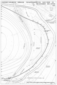
At the intake the floor of the channel was lower than the bottom of the river so, even with a modest water level in the Ruwer river, there was a constant water supply.
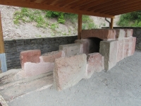
Especially from the river tap to Waldrach also sandstone blocks were used as building blocks for the aqueduct to replace (in a later phase ?) the regular lime stone masonry.
After the first 425m of its course, an extra water supply channel (N) was added, probably a later addition, see drawing ad M.
Because of local problems with the construction, on seven places a second channel was added on the higher sides of the existing ones.
Visible remains
The aqueduct is at display at only a few locations (see also the GPS-coordinates):
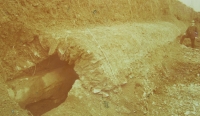
- Parking lot above Waldrach (49 44 24N, 06 44 34E)
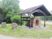
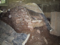
In the valley of the Ruwer, just above Waldrach at a parking place along the K12 road, a replica of the aqueduct was built on a concrete base.
The material came from the original aqueduct that was excavated because of road construction work. At both side of the segment, there is ample information
available on the side panels.
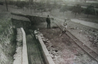
This place can easily be reached from the Ruwer cycle path (the former railway track) but it is nog signposted (2015).
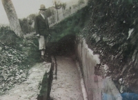
- Along the Ruwer cycle path (49 44 47,75N, 06 44 27,50E)
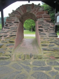
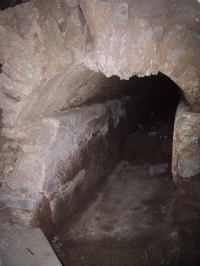
Just behind the old railway station in Waldrach, along the Ruwer cycle path, a part of the sandstone blocks version of the aqueduct is displayed and
protected by a kind of roof. Note the modes information panel.
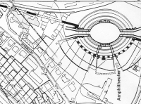
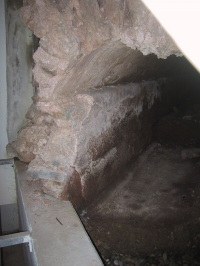
- Roman city wall (49 45 00N, 06 38 58,50E)
During reconstruction work at the grounds of the old Lowen brewery (just N of the amphitheater), archaeologists struck upon the place where the Ruwer aqueduct
crossed the city wall. This finding proofed that the aqueduct was younger than the city wall on this place. The remains are at display in the cellar of a flat building
at the Schutzenstrasse 20 / Bergstrasse in Trier. Some remains can be seen from outside. For a visit, contact the housekeeper at #49 651 9919 519
or the Rheinisches Landes Museum Trier.
- Barbara thermen (49 45 00N, 06 37 49E)
The Roman aqueduct and the enormous Barbara Thermen (Barbara Baths) were contemporaneous although a direct link between both structures is not (yet) established.
Unfortunately the Barbara Baths are in restoration for a quite long time. Both the Viehmarkt and the Kaiser baths were of later date.
Wilke D. Schram
Trier - COLONIA AUGUSTA TREVERORUM (CAT)
| Item
| Info
|
| Length |
12,8 km |
| Cross-section |
0,74 x 1,30 m |
| Volume |
25.000 m3/day |
| Gradient |
0,06 % |
| Period |
2 c AD |
| Features |
- River tap
- Partly double channel
- Putei
|
| Recommended literature :
|
- E. Samesreuther (1936): Romische Wasserleitungen in den Rheinlanden
- A. Neyses (1975): Die römische Ruwerwasserleitungen nach Trier im Ablaufgebiet Tarforst - Waldrach (in: Trierer Zeitschrift vol 38 (1975) pag 75 - 100)
- A. Neyses (1983): Die Ruwer-Wasserleitung des römischen Trier (in: J.-P. Bucher (1983): Journées d'Etudes sur les Aqueducs Romains p 275 - 292)
- H. Cüppers (2005): Die Roemer in Rheinland-Pfalz p 586-588
- Führer zu archäologischen Denkmahlern der Trierer Landes (2008) p 64 ff and 184ff (RLM Schriftenreihe nr 35)
- B. Busch (2010): Die Ruwer-Wasserleitung des römischen Trier (in: Jahrbuch 2011 Kreis Trier-Saarburg) p171 - 174
|
| Recommended website :
| none
|
| How to visit :
| Ask the Tourist Information for the Ruwer cycle path.
The Bergstrasse is on the north side from the amphitheater; a 15 minutes walk from the Rheinisch-Germanisches Museum.
|