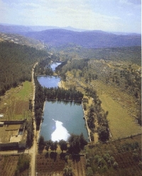
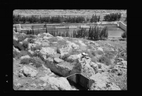
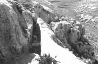
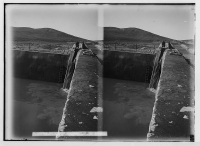
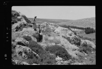
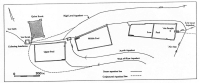
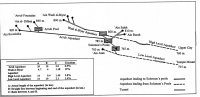
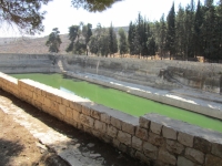
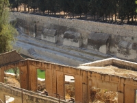
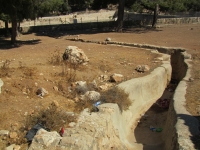
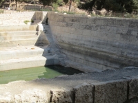
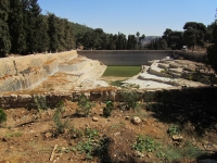
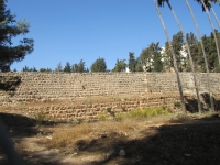
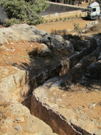
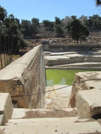
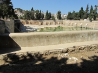
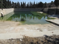
Jerusalem 1 (Israel)

Roman aqueducts: The aqueducts of Jerusalem Jerusalem - after 135 AD/CE: AELIA CAPITOLINA

For Part 2, see column left Supplementary to this entry is an overview of the Pools of Jerusalem, see column left For the photo's, see below Time line Land of Israel Home / the complete website


"The growth of Jerusalem in the Second Temple period and the massive sacrificial activity on the Temple Mount caused a major problem of water supply. The solutions that has been provided in the First Temple period - exploitation of the Gihon waters, digging of cisterns under the houses, and the construction of large public pools - no longer sufficed" (from: Mazar 2002).

In particular during the three annual pilgrimage festivals - Pesach, Shavu'ot, and Sukkot - huge amounts of water were needed. The construction of aqueducts, bringing fresh water to the city, would solve this problem.

An overview of Jerusalem's aqueduct system

Air photo of the Solomon's Pools
The water supply system of Jerusalem, which reached its height in the late Second Temple period, consists of several independent but interconnected elements which were built/re-built at different times. It was explored and mapped by the 19th century explorers Charles Wilson and Conrad Schick and again in recent times by Amihai Mazar and others. The heart of the system is Solomon's Pools, three reservoirs which descend in stair-step fashion down the Artas Valley just southwest of Bethlehem.

They are monumental and quite astounding, with a combined surface area equal to more than four football fields and a capacity of over a quarter million cubic meters. The pools serve as a kind of junction or interchange for the system. Besides collecting rainwater from the plains to the west and the output of some local springs, the pools receive the water of the two major supplying aqueducts and then send it all out through three channels to Jerusalem en Herodion (all discussed below). The Solomon's Pools - surely not built in the time of King Solomon - were completely refurbished by the British in 1924, when a pumping station was also installed, to send the water through iron pipes to the Old City.

Wadi el-Biyar aqueduct

One of the two channels feeding Solomon's Pools from the south is the Wadi el-Biyar aqueduct. It is 4,7 km long and descends at a gradient of 1,9%. Compared to the other aqueducts in the system, it is the shortest, straightest and steepest. It runs roughly parallel to today's Road 60, about 1 km to the east of the road. It actually collected water in three ways: 1) it conducted water from three springs in Wadi el-Biyar; 2) it collected rainwater from the valley via a series of dams and shafts; and 3) along much of its length it was constructed as a trench / tunnel hewn tapping an aquifer layer like a qanat. Thus, along the seam between two strata the aqueduct itself is draining the aquifer - like a long, continuous layer spring - with water flowing in through the tunnel walls! This technique, which the Romans borrowed from the Persians, is seen nowhere else in Israel-Palestine. Built probably in the time of Herod the Great, the Wadi el-Biyar aqueduct remained in service for much of the next 2000 years. It was refurbished by the British along with Solomon's Pools in 1924 and provided water for Jerusalem's Old City until 1967.

'Arrub aqueduct

The other channel feeding Solomon's Pools is the 'Arrub aqueduct. It gathered the waters of a group of springs lying between Hebron and Bethlehem and then, following the contours of the ridges and wadi's, wound through the Judean hills for an astounding 40 km - the straight-line distance was 10 km - at an equally amazing gradient of only 0,09% ! For much of its length it was a simple channel hewn into the bedrock slopes, plastered and capped with stone slabs.
Obstacles were overcome via two methods: tunneling through some ridges, and elevating the channel on a stone wall/dam in order to cross wadi's. The dating of the 'Arrub aqueduct is not certain, but it is a good candidate for the aqueduct mentioned by Josephus for which Pontius Pilate appropriated Temple funds, thereby sparking riots in Jerusalem (Antiquities 18). It seemingly was re-built in the Mamluk period and finally went out of service in Ottoman times. Its great length made it especially susceptible to damage or clogging, unauthorized tapping of the water, and the pilfering of cap-stones.

Other water channels

"He [Herod] spent money from the sacred treasury in the construction of an aqueduct to bring water into Jerusalem, intercepting the source of the stream at a distance of thirty-five kilometers. The Jews did not acquiesce in the operations that this involved; and tens of thousands of men assembled and cried out against him, bidding him to relinquish his promotion of such designs".

Flavius Josephus, Jewish Antiquities 18.60-62
One channel, unrelated to Jerusalem's water supply, and thus only mentioned here, is the Herodion aqueduct, descending eastward from Solomon's Pools, through the Artas Valley, and ending at that desert fortress of Herod the Great; it can thus be dated to the 1st century BC. It was long thought that its source was the spring of Artas, but further analysis and excavation now show it to be connected to and fed by Solomon's Pools.
But 'Ain Urtas was indeed the source of an aqueduct, but serving another purpose. Although its final destination is not fully established, its course can be followed for quite a distance, via a watermill 2 km SW of Urtas towards the orchards of St. Chariton monastery (nrs 31 - 41 on the map below) in the Wadi Khureitum (amit 1994). The total length was 5 - 6 km, its internal section trapezoidal of decreasing size: at the bottom 30 - 15 cm).

Upper Aqueduct

Another channel is the Upper Aqueduct of Jerusalem. It began at Solomon's Pools, ran northward, close to the watershed line at a higher elevation than its 'lower' counterpart. It skirted Bethlehem on the west side, closely paralleled today's Hebron Road, and apparently had as its destination 'Hezekiah's Pool' in the Upper City. Its length was 14 km, with an average gradient of 0,28%. Its best-known remains are a still-visible section of stone pipe (part of a siphon) across a shallow valley south of Rachel's Tomb. Based on inscriptions of the 10th Roman Legion on the pipe segments, the Upper Aqueduct was long dated to the Late Roman period. However it is now clear that there was an earlier, parallel, high-level aqueduct section (i.e., elevated on arches), an earlier solution to the same topographical problem, i.e. transmission of the water across the valley. Several surviving piers of this high-level section were discovered and documented in the 1980s and '90s but were later removed in a building project.
Thus, the Upper Aqueduct is now thought to have been Herodian in its earliest phase, then re-built in the Late Roman period, and it may have gone out of use after the Byzantine era. Overall, it is not well-preserved.
No remains have been found from the area of Jerusalem's old railway station northward, except for its confluence with the Mamilla Pool outflow channel, in the direction of the Old City but it did not feed that pool: the elevation was not sufficient.
After passing under the medieval fore-wall north of Jaffa Gate, segments were found recently close to Hezekiah's pool with which a connection could be proved.


Wilke Schram
mainly based on the article on the web "The Lower Aqueduct of Jerusalem" by Tom Powers (2007)


For Part 2, see column left Supplementary to this entry is an overview of Larger pools in Jerusalem For the photo's, see below Time line Land of Israel


Solomon pools

Dimensions according to Mazar 2002
(in meters) L x W H Capacity (m3)
Upper Pool 71 x 118 9,5 - 11,0 85.000
Middle Pool 135 x 50 10 - 12 90.000
Lower Pool 179 x (46 - 81) 8 - 16 113.000
Total     228.000 m3

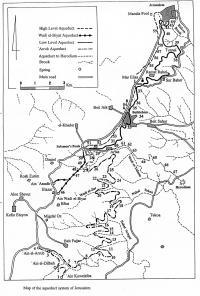
Capacity of the water sources

According to Mazar 2002
(in m3) Annual Daily
Wadi el-Biyar 91.000 250
'Arrub 227.000 625
Local sources )* 42.000 115
Total   990 m3/day
Excluding leakages and evaporation during transport
)* Local sources: 'Ain Attan, 'Ain Saleh, 'Ain Burak, and 'Ain Farujeh

The total storage capacity in the Solomon's pools was 228.000 m3.
So it took over 200 days to fill the Solomon's Pools,
excluding the considerable (Mazar 2002) amount of run-off rain water
from the el-Hadr plateau near the pools.


Jerusalem - (after 135 AD/CE) AELIA CAPITOLINA

Aqueduct Wadi el-Biyar 'Arrub Herodion Upper Lower
Length (km) 4,7 39 9 14 21
Cross-section (m x m) 0,2-0,8 x 1,5-3,0 0,5-0,6 x 0,6-0,7 narrowing from
0,85-0,45 x 1,25-0,75
0,5 x 0,75 0,4-0,5 x 0,6-0,75
Volume m3/day )* 250 625 ?? - -
Gradient (%) 19 0,9 ?? 2,8 1,4
Period Herod Pilate Herod Herod )** Hasmonean
Features Through an aquifer Sinuous course From Solomon's Pools
to Herodion
Siphon Visitable tunnel
Notes:
Apart from the Herodion aqueduct, all these aqueducts underwent considerable repairs and alterations over time
)* The Upper and Lower Aqueducts did not have sources of its own but were fed from the Solomon's Pools
)** Plus serious reworked by the Romans, a.o. a siphon near Bethlehem


Recommended literature :
  • D. Amit (editor) (2002) The Aqueducts of Israel, also available in Hebrew (1989), with interesting articles like:
    • A. Mazar: A survey of the aqueducts to Jerusalem
    • Y. Billig: The low-level aqueduct to Jerusalem
    • D. Amit: New data for dating the high-level aqueduct ...
  • D. Amit (1994): What was the source of Herodion's water? In: Liber Annuus vol 44 (1994) pag 561 - 578.
    Also on the web
  • T. Tsuk (2011): Water at the end of the tunnel, touring Israel's ancient water systems (in Hebrew)
Recommended websites   :
How to visit                  : see above

HOME More literature on more aqueducts Last modified: February, 2013 - (webmaster)


Maps of the aqueducts

Channel of el-Biyar

Tunnel in the el-Biyar

el-Biyar adn Solomon's Pools

The 'Arrub aqueduct

Pool in stereo photography

'Arrub plus Solomon's Pools

Air view of Solomon's Pools

Map of the Solomon's Pools

Map of the aqueduct system

The Lower pool

Buttresses of the Lower pool

Supply for the Lower pool

Third set of stairs

The Middle pool

Lower outer wall

Supply for the Middle pool

Access to the Middle pool

Level indicator

The Upper pool

Stair case

"Collecting Installation"

Qalaat Burak

Map of two aqueducts

Cross-section siphon

Siphon remains in Bethlehem

Square stones of the siphon

Look into the siphon pipe

Stone Blocks

In the Rockefeller Museum

In the Israel Museum

Second use

Near the Jaffa Gate

View into the Upper aqueduct

Pool in the Upper aqueduct

Water inlet