Jerusalem 2 (Israel)

Roman aqueducts: The aqueducts of Jerusalem part 2 Jerusalem - after 135 AD/CE: AELIA CAPITOLINA
For Part 1, see column left Supplementary to this entry is an overview of the Pools of Jerusalem, see column left For the photo's, see below Time line Land of Israel Home / the complete website

Lower Aqueduct

The Lower Aqueduct represents a true link between antiquity and modern times: from its original construction in the Hasmonean period, it continued to deliver water to Jerusalem off and on, through various alterations, until the turn of the 20th Century! Other parts of the system were actually supplying water to the Old City until 1967.
The Lower Aqueduct of Jerusalem ran for 21,5 km from Solomon's Pools (765 m asl) to the Temple Mount (735 m asl). In that distance, it dropped a mere 30 meters, for a gradient of 0,14%. Put another way, in the length of a football field, the floor of the channel dropped only 14 cm!
The original Lower Aqueduct has now been firmly dated to the Hasmonean period. This is based not only on ceramics and coins related to its construction but also similarities to the water systems of the Hasmonean desert fortresses, including a distinctive type of plaster. Thus, along with one or more of the Solomon's Pools, it is in its original form the oldest part of Jerusalem's aqueduct system. It is mentioned a number of places in the Talmud, which says that "... an aqueduct ran to [the Temple] from Eitam [a spring located near Solomon's Pools]" and a Midrash states that the same aqueduct was destroyed by the sicarii during the Great Revolt in the seventies.

The route of the Lower Aqueduct

Location: the west bank of the Hinnom Valley, above the Sultan's pool and near the entrance to Mishkenot Sha'anananim. This part of the Lower aqueduct of Jerusalem can be viewed both from the stepped path which runs below it and from the paved overlook above.
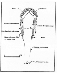
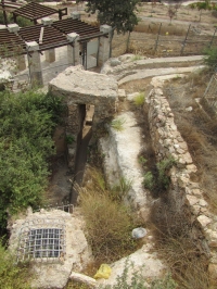
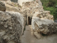
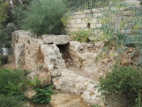
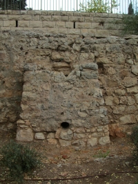
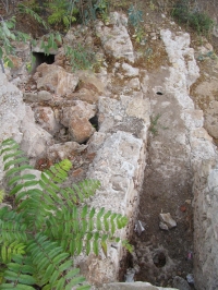
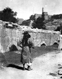
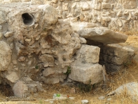
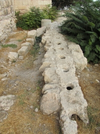
What we see here is quite simple: the constructed water channel is elevated atop a buttressed stone wall, in order to maintain the required gradient. It is plastered inside to prevent leakage and capped with stone slabs in order to minimize evaporation and contamination of the water.
What we actually see is the aqueduct as rebuilt and repaired in the late Ottoman period, but at its core it is Hasmonean. It can only be properly understood in relation to the larger system of which it is one part.
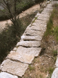
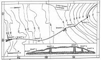
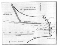
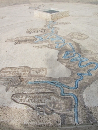
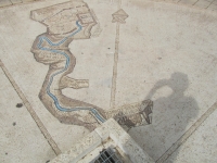
This segment of several meters that has been restored and left exposed here is a small part of a system that stretches over 60 km from its furthest sources to its destination. It is vast and ingenious, representing the finest of ancient engineering, and is easily the longest and most complex aqueduct system in the Land of Israel, including even Caesarea.
From Solomon's Pools it led northward and ran beneath the town of Bethlehem through a tunnel, which is mostly blocked today. Reaching the Armon HaNatziv ridge (Jebel Mukkaber / Eeat Talpiot) it overcame this barrier by means of a tunnel stretching nearly 400 m and was punctuated by six vertical shafts, one of which is 40 m deep and pierced an already present cistern.
The top of the shafts can easily be visited at the park 200 m east of the roundabout at the end of the Haas promenade. Shaft 4 has been embellished by a mosaic of a map of the Lower Aqueduct, made by Chaim Kapchich. Information panels near shaft 5 - adjacent to the road to the headquarters of UNTSO - give interesting details of the aqueduct. The City of David organization organizes weekly a two hours tour through the dry Armon HaNatziv tunnel at Friday, see their website. For more details about the tunnel see the website of JerusalemSegway.

The channel emerges from the tunnel just east of and down slope from today's Haas Promenade, continues below the Sherover Promenade and then across the slopes of Abu Tor, to the western slopes of the Hinnom Valley. Note that many of the aqueduct remains in the area of HaNatziv, the Tayelet, and the Peace Forest have been preserved and marked.

From Mishkanot Sha'ananim, the Lower Aqueduct continues northward past the Sultan's Pool, and many remains of this section can still be traced with a little effort: from the west end of the road bridge below Sultan's pool, follow the footpath directly up the western slope of the Hinnom valley. Also visible is the beginning of a pipe line from the aqueduct towards the pool, an addition of later date.
North of the Sultan's Pool it then traverses the Hinnom Valley on an arched stone bridge. This bridge - the Mamluk version, complete with a dedicatory inscription - was visible into the early 20th century, but was then totally obscured by modern grading and landscaping. As of 2010, two complete arches near the western end of the bridge were exposed once again in an infrastructure project; a plan has been announced to uncover the entire bridge in the years to come.

The aqueduct continues around the slopes of Mt. Zion and then beneath (outside) the present-day city walls where interesting remains are easily accessible. Entering the Old City west of Dung Gate, it proceeds through today's Jewish Quarter, where portions are preserved along the scarp of the Western Hill (Josephus' 'Upper City') opposite the southwestern corner of the Haram al-Sharif (Herodian Temple Mount).

Via the Wilson's Arch bridge, the Lower Aqueduct led onto the Temple Mount to its ultimate (original) destination, the cisterns beneath the Haram platform. The 19th century explorers Conrad Schick and Charles Warren demonstrated that the Haram is pockmarked - akin to a Swiss cheese - with numerous water reservoirs and channels, and their mapping and numbering system still provide our only scientific knowledge of these spaces. They identified a water channel leading from Wilson's Arch in the direction of two particular cisterns, numbers 6 and 36 on the map below.

Very nearby is the largest of the Temple Mount cisterns, the one the explorers dubbed 'The Great Sea.' Accompanying Warren in 1869, the English artist William 'Crimea' Simpson sketched this cavernous reservoir by the light of a burning magnesium wire, and later produced this watercolor. It is still not known whether or how these various cisterns might be connected.

Alterations to the Lower Aqueduct

Starting at HaNatziv and running all the way into today's Jewish Quarter there is a second, parallel channel constructed at a slightly higher level; this is not to be confused with the 'Upper Aqueduct'. In some places it is a separate, adjacent channel, and in others, like here in Mishkenot Sha'ananim, it exactly overrides and obscures the older Hasmonean channel. Thus, the original, lower channel was rendered forever useless. This shows clearly that the destination and uses of the water changed over time. A good guess for this rebuilding is the Byzantine period, when Jerusalem was burgeoning and the Temple Mount, by all accounts, lay unoccupied and largely forgotten. A drawing of Conrad Schick in fact shows this higher channel passing very near the top of the great vaulted cistern of the Nea Church, one possible destination for the water.

In the Early Islamic and Crusader periods, the water was probably once again directed to the Temple Mount via Wilson's Arch. At the southwest corner of the Temple Mount, the large horizontal grooves cut into the Herodian masonry probably held pipes which, in the Umayyad period (660-750 CE), conducted at least some of the water to the large palaces or pilgrim hostels situated there.
The aqueduct was restored and rebuilt by the Mamluks. Their arched bridge crossing the Hinnom Valley was visible into the 20th century, was then buried, and will be exposed once again.
The Ottoman Turks reconstructed the Lower Aqueduct along its entire length, laying a closed ceramic pipes into the existing channel in the 1500s. The pipes made the aqueduct more vulnerable to blockage, but it continued in use, off and on, into modern times.

In 1902, the Ottomans bypassed most of the ancient Lower Aqueduct by constructing a shunt of iron pipes on a more direct line from Bethlehem to the Old City. This pipeline never worked well, however, until the British installed pipes all the way from Solomon's Pools and built a pumping station there in 1924, a system which continued to supply water to the Old City until 1967. The partially-ruined pumping station structures, with much of the original apparatus still in place, are still visible near Solomon's Pools.

During the British Mandate period, in the early 20th century, the waters of ancient source 'Ain 'Arrub, which had long since ceased flowing through the 'Arrub feeder aqueduct, began to be pumped up to a higher level, to the Bethlehem-Hebron road (today's Road 60) lying to the west. From a pumping station there, the water was shunted into the still-operational Biyyur feeder aqueduct. In this way the 'Ain Arrub waters were captured once again for Solomon's Pools and for modern use in Jerusalem.

Wilke Schram
mainly based on the article on the web "The Lower Aqueduct of Jerusalem" by Tom Powers (2007)


For Part 1, see column left Supplementary to this entry is an overview of Larger pools in Jerusalem For the photo's, see below Time line Land of Israel


A short history of the Lower Aqueduct of Jerusalem

also called: Low Level Aqueduct. From: Billig 2002

Time Event
1st c BC/BCE Construction of the Lower aqueduct as an open channel, in the time of Alexander Jannaeus or Herod the Great
70 AD/CE Out of use during and after the Great Revolt (so in Roman times only the High Level Aqueduct was in use)
4 - 7th c AD/CE Repairs in Byzantine time including the construction of a settling basing at the entrance of the Armon NaHatziv tunnel
post 7th c AD/CE A second channel (bypass) was added, slightly higher than the original channel, to reach higher places in Jerusalem, perhaps the reservoir under the Nea Church
7 - 10th c In Umayyad / Abbasside period the water went to the Temple Mount again
13 - 15th c Possibly repairs in the Mamluks period
16th c In the early Ottoman period terracotta pipes with holes on top, enveloped in concrete were laid in the bypass channel
1900 In the late Turks period the Armon NaHatziv tunnel was deepened, its pipes were dismantled and the tunnel was put in use as a reservoir.
An iron pipeline was built from Bethlehem, via the Armon NaHatziv tunnel towards Jerusalem, lowing its own course with a branch line to the Sultan's pool
post 1914 During the Mandate period reinforced concrete pipes were placed inside the tunnel, connecting the iron pipes at both ends
Wilke Schram


Jerusalem - (after 135 AD/CE) AELIA CAPITOLINA

Aqueduct Wadi el-Biyar 'Arrub Herodion Upper Lower
Length (km) 4,7 39 9 14 21
Cross-section (m x m) 0,2-0,8 x 1,5-3,0 0,5-0,6 x 0,6-0,7 narrowing from
0,85-0,45 x 1,25-0,75
0,5 x 0,75 0,4-0,5 x 0,6-0,75
Volume m3/day )* 250 625 ?? - -
Gradient (%) 19 0,9 ?? 2,8 1,4
Period Herod Pilate Herod Herod )** Hasmonean
Features Through an aquifer Sinuous course From Solomon's Pools
to Herodion
Siphon Visitable tunnel
Notes:
Apart from the Herodion aqueduct, all these aqueducts underwent considerable repairs and alterations over time
)* The Upper and Lower Aqueducts did not have sources of its own but were fed from the Solomon's Pools
)** Serious reworked by the Romans, a.o. a siphon near Bethlehem


Recommended literature :
  • D. Amit (editor) (2002) The Aqueducts of Israel, also available in Hebrew (1989), with interesting articles like:
    • A. Mazar: A survey of the aqueducts to Jerusalem
    • Y. Billig: The low-level aqueduct to Jerusalem
    • D. Amit: New data for dating the high-level aqueduct ...
  • D. Amit (1994): What was the source of Herodion's water? In: Liber Annuus vol 44 (1994) pag 561 - 578.
    Also on the web
  • T. Tsuk (2011): Water at the end of the tunnel, touring Israel's ancient water systems (in Hebrew)
Recommended websites   :
How to visit                  : see above

HOME More literature on more aqueducts Last modified: February, 2013 - (webmaster)


Cross-section of the tunnel

Plan plus shaft numbers

Cross-section of the channel

Aqueduct mosaic

'Arrub aqueduct

Towards the Temple Mount

40 m deep shaft nr 4

Entrance of the tunnel

Start of the tunnel

Lower aqueduct channel

Later added branch

Pipes inside the channel

Mamluk bridge

Pipe line along the road

Two aqueduct courses

Two channels and one pipe

Channel and pipe line

Course around the Upper City

Channel plus pipe

Lower aqueduct and cisterns

Last stretch?

The great Sea