Note:
Interesting literature on the mathematical side of surveying:- Tom M. Apostol: The tunnel of Samos (nd)
- K.D. Matheuws: Roman aqueducts, technical aspects of their construction (1970)
© Matthias Kabel 2008
Surveying
The Romans attributed great antiquity to land surveying. Indeed, there is some evidence of Etruscan roots in the Roman methods and religious rites. The Romans insisted in setting the groma with correct auspices. The whole notion of boundaries and boundary marks had religious significance to the Romans. Rome was also indebted to Greece and Carthage, though it is unlikely they would admit to the latter (Dilke, 1971:31). The Roman system of education was not very technical.Nonetheless, surveyors had an adequate grounding in geometry, orientation, sighting and levelling, distance calculations, astronomy and cosmology and perhaps a little law. The latter was probably limited to the law governing the classification of land and those concerning boundaries and boundary disputes (Dilke, 1971:47). These traditional surveying skills would have been directly applicable to planning and surveying the aqueducts' courses.
Since the aqueducts were operated by gravity the course of the channel had to be carefully planned so that it would maintain a steady slope. A steep gradient was avoided, since faster flowing water would erode the channel walls and threaten the stability of the structure, especially at bends. These constraints would have affected possible courses the aqueducts took. Vitruvius gives a figure of 0.5% as an ideal angle of descent, but in practice this varied considerably, the average gradient usually lying between 0.15% and 0.3%, due to the constraints of geography. The aqueducts of Rome were typically closer to the higher number; the terrain is quite hilly. The skills needed to level must have been in regular use too; it is unlikely that the Romans rediscovered them every time they built an aqueduct.
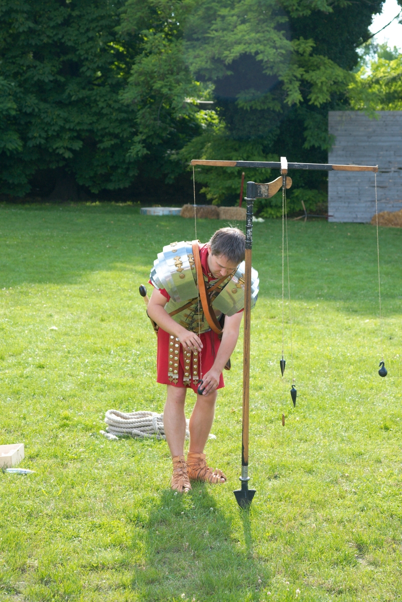
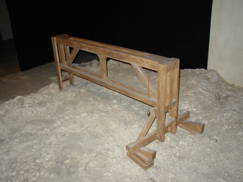
Vitruvius recommends the chorobates as the most accurate surveying instrument for levelling. In tunnels where it would be impractical, a simple water level could be used. Since the tunnels were connected to the surface with vertical shafts at frequent intervals, it was generally not difficult to keep the tunnel straight (Aicher, 1995:8). A plumb line could measure both the depth of the tunnel below the surface and ensure that the shaft descended vertically.
An inspection of Roman roads, aqueducts, canals, buildings, city layouts, and land subdivisions confirms their unexcelled proficiency in the use of crude surveying instruments as measured by modern-day standards. Further inspection of archeological and written evidence suggests the following points:
- The range of Roman instruments was restricted to the vision of the naked eye, magnification by telescopic sights came in 1608
- There is no evidence of the use of the compass
- Large scale maps were greatly distorted in the E-W direction because the methods used for locating relative latitude and longitude were not sufficiently accurate for cartographical purposes.
- Their entire astronomical and geographical outlook was circumscribed by the idea of an earth-centered universe and a rigid Euclidean geometry excellent for earth measurements but elementary when projected into space. They understood a great deal of algebra and trigonometry but very little calculus.
From: Evan J. Dembskey's thesis and (only the last part) www.surveyhistory.org
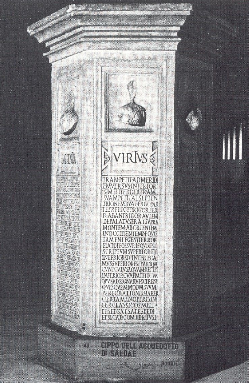
The tunnel of Saldae (Algeria)
There is an official report of the perforation of a tunnel, to bring down to Bougie, Algeria (called then Saldae or Civitas Salditana), the waters of a spring, fourteen miles distant, now called Aďn-Seur. The report, engraved on a marble altar, discovered in 1866 near Lambaese, begins with a petition addressed in the year 152 A.D. by Varius Clemens, governor of Mauritania, to Valerius Etruscus, governor of Numidia. The petition reads as follows:"Varius Clemens greets Valerius Etruscus, and begs him in his own name and in the name of the township of Saldae to dispatch at once the hydraulic engineer of the III legion, Nonius Datus, with orders that he finish the work, which he seems to have forgotten."The petition was favorably received by the governor and by the engineer, Nonius Datus, who, when he had fulfilled his mission, wrote to the magistrates of Saldae the following report:
After leaving my quarters I met with the brigands on my way, who robbed me even of my clothes, and wounded me severely. I succeeded, after the encounter, in reaching Saldae, where I was met by the governor, who, after allowing me some rest, took me to the tunnel. There I found everybody sad and despondent; they had given up all hopes that the two opposite sections of the tunnel would meet, because each section had already been excavated beyond the middle of the mountain, and the junction had not yet been effected. As always happens in these cases, the fault was attributed to the engineer, as though he had not taken all precautions to insure the success of the work. What could I have done better? I began by surveying and taking the levels of the mountain; I marked most carefully the axis of the tunnel across the ridge; I drew plans and sections of the whole work, which plans I handed over to Petronius Celer, then governor of Mauritania; and, to take extra precaution, I summoned the contractor and his workmen, and began the excavation in their presence, with the help of two gangs of experienced veterans, namely, a detachment of marine-infantry (classicos milites), and a detachment of Alpine troops (gaesates). What more could I have done? Well, during the four years I was absent at Lambaese, expecting every day to hear the good tidings of the arrival of the waters at Saldae, the contractor and the assistant had committed blunder upon blunder; in each section of the tunnel they had diverged from the straight line, each towards his right, and, had I waited a little longer before coming, Saldae would have possessed two tunnels instead of one.Nonius Datus, having discovered the error, caused the two diverging arms to be united by a transverse channel; the waters of An-Seur could finally cross the mountain; and their arrival at Saldae was celebrated with extraordinary rejoicings, in the presence of the governor Varius Clemens and of the engineer.
From: Bill Thayers website